Fitxer:Ottoman_Provinces_Of_Present_day_Libyapng.png
From Wikipedia, the free encyclopedia
No hi ha cap versió amb una resolució més gran.
Ottoman_Provinces_Of_Present_day_Libya.png (282 × 314 píxels, mida del fitxer: 22 Ko, tipus MIME: image/png)
| Aquest fitxer i la informació mostrada a continuació provenen del dipòsit multimèdia lliure Wikimedia Commons. |

|
Aquesta imatge (de tipus locator map) s'hauria de tornar a crear utilitzant gràfics vectorials com ara un fitxer SVG. Això té diversos avantatges; en trobareu més informació a Commons:Media for cleanup. Si ja disposeu d'una versió d'aquesta imatge en format SVG, us preguem que la pengeu; després, reemplaceu aquesta plantilla amb la plantilla {{Vector version available|nom nou de la imatge.svg}} en aquesta imatge.
|
Resum
| DescripcióOttoman Provinces Of Present day Libya.png |
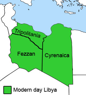
English: The Ottoman Turks conquered the country in the mid-16th century, and the three States or "Wilayat" of Tripolitania, Cyrenaica and Fezzan (which make up Libya) remained part of their empire with the exception of the virtual autonomy of the Karamanlis. The Karamanlis ruled from 1711 until 1835 mainly in Tripolitania, but had influence in Cyrenaica and Fezzan as well by the mid 18th century. |
|||
| Data | ||||
| Font | self-made but based on this image on this image and this image | |||
| Autor | Esemono; improved by Kirk (talk) | |||
| Permís (Com reutilitzar aquest fitxer) |
|
|||
| Altres versions |
Derivative works of this file:
   |
Llegendes
Afegeix una explicació d'una línia del que representa aquest fitxer
Elements representats en aquest fitxer
representa l'entitat
Historial del fitxer
Cliqueu una data/hora per veure el fitxer tal com era aleshores.
| Data/hora | Miniatura | Dimensions | Usuari/a | Comentari | |
|---|---|---|---|---|---|
| actual | 14:53, 24 ago 2011 | | 282 × 314 (22 Ko) | Kirk979 | See discussion |
| 22:46, 11 abr 2011 |  | 300 × 350 (35 Ko) | ANGELUS | border | |
| 22:35, 11 abr 2011 |  | 300 × 350 (39 Ko) | ANGELUS | improved | |
| 19:35, 12 oct 2009 |  | 282 × 314 (22 Ko) | Kirk979 | corrections | |
| 13:00, 1 març 2009 |  | 282 × 314 (29 Ko) | Kirk979 | corrections | |
| 15:43, 17 abr 2008 |  | 282 × 314 (25 Ko) | Esemono | Category:Maps of Libya Category:Map images that should use vector graphics |
Ús del fitxer
Les 5 pàgines següents utilitzen aquest fitxer:
Ús global del fitxer
Utilització d'aquest fitxer en altres wikis:
- Utilització a ar.wikipedia.org
- Utilització a azb.wikipedia.org
- Utilització a az.wikipedia.org
- Utilització a be.wikipedia.org
- Utilització a bg.wikipedia.org
- Utilització a bs.wikipedia.org
- Utilització a cs.wikipedia.org
- Utilització a da.wikipedia.org
- Utilització a el.wikipedia.org
- Utilització a en.wikipedia.org
- Cyrenaica
- Districts of Libya
- Fezzan
- Tripolitania
- Governorates of Libya
- Subdivisions of Libya
- Provinces of Libya
- Postage stamps and postal history of Tripolitania
- Kingdom of Libya
- Postage stamps and postal history of Cyrenaica
- Postage stamps and postal history of Libya
- Postage stamps and postal history of Fezzan and Ghadames
- Template:Regions of Libya
- Category:Regions of Libya
- Revenue stamps of Libya
- Tripolitania (province of Libya)
- Cyrenaica province
- Fezzan province
- Utilització a eo.wikipedia.org
- Utilització a eu.wikipedia.org
Vegeu més usos globals d'aquest fitxer.
Metadades
Aquest fitxer conté informació addicional, probablement afegida per la càmera digital o l'escàner utilitzat per a crear-lo o digitalitzar-lo. Si s'ha modificat posteriorment, alguns detalls poden no reflectir les dades reals del fitxer modificat.
| Data i hora de modificació del fitxer | 17:34, 12 oct 2009 |
|---|---|
| Resolució horitzontal | 28 ppc |
| Resolució vertical | 28 ppc |