Fitxer:Seven+Summits+Elevation+World+Map.png
From Wikipedia, the free encyclopedia
Mida d'aquesta previsualització: 800 × 400 píxels. Altres resolucions: 320 × 160 píxels | 640 × 320 píxels | 1.524 × 762 píxels.
Fitxer original (1.524 × 762 píxels, mida del fitxer: 1,77 Mo, tipus MIME: image/png)
| Aquest fitxer i la informació mostrada a continuació provenen del dipòsit multimèdia lliure Wikimedia Commons. |
Resum
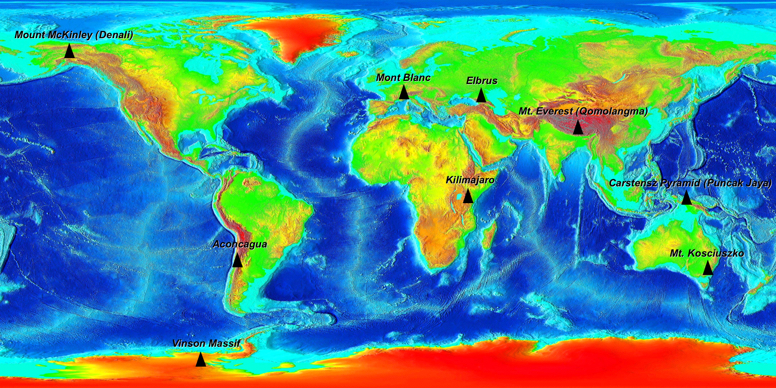
| DescripcióSeven+Summits+Elevation+World+Map.png |
The Seven Summits on an Elevation World Map. (For more information on why 9 peaks are on this map read the wikipedia Seven Summits article.) Elevation key: Green < 500m, Yellow <1000m, Orange <2000m, Red <3000m, Dark Red <5000m, Grey >5000m |
| Data | |
| Font |
Own work based on Image:Elevation.jpg Original file from https://www.ngdc.noaa.gov/mgg/image/2minrelief.html |
| Autor |
Base image: National Oceanic and Atmospheric Administration Tagged: Ma xyz |
| Permís (Com reutilitzar aquest fitxer) |
PD |
Llicència
| Public domainPublic domainfalsefalse |
| Jo, el titular del copyright d'aquesta obra, l'allibero al domini públic. Això s'aplica a tot el món. En alguns països això pot no ser legalment possible, en tal cas: Jo faig concessió a tothom del dret d'usar aquesta obra per a qualsevol propòsit, sense cap condició llevat d'aquelles requerides per la llei. |
Llegendes
Afegeix una explicació d'una línia del que representa aquest fitxer
Elements representats en aquest fitxer
representa l'entitat
9 ago 2006
Historial del fitxer
Cliqueu una data/hora per veure el fitxer tal com era aleshores.
| Data/hora | Miniatura | Dimensions | Usuari/a | Comentari | |
|---|---|---|---|---|---|
| actual | 05:29, 10 ago 2006 | | 1.524 × 762 (1,77 Mo) | Ma xyz | {{Information |Description=The Seven Summits on an Elevation World Map |Source=own work based on Image:Elevation.jpg |Date=2006-08-09 |Author=The Uploader |Permission=PD |other_versions= }} |
| 05:07, 10 ago 2006 |  | 1.525 × 763 (1,78 Mo) | Ma xyz | {{Information |Description=The Seven Summits on an Elevation World Map |Source=own work based on Image:Elevation.jpg |Date=2006-08-09 |Author=The Uploader |Permission=PD |other_versions= }} |
Ús del fitxer
La pàgina següent utilitza aquest fitxer:
Ús global del fitxer
Utilització d'aquest fitxer en altres wikis:
- Utilització a ar.wikipedia.org
- Utilització a ast.wikipedia.org
- Utilització a be-tarask.wikipedia.org
- Utilització a be.wikipedia.org
- Utilització a bn.wikipedia.org
- Utilització a cs.wikipedia.org
- Utilització a da.wikipedia.org
- Utilització a de.wikipedia.org
- Utilització a en.wikipedia.org
- Utilització a es.wikipedia.org
- Utilització a et.wikipedia.org
- Utilització a eu.wikipedia.org
- Utilització a fa.wikipedia.org
- Utilització a fi.wikipedia.org
- Utilització a gl.wikipedia.org
- Utilització a he.wikipedia.org
- Utilització a hi.wikipedia.org
- Utilització a id.wikipedia.org
- Utilització a inh.wikipedia.org
- Utilització a it.wikipedia.org
- Utilització a ja.wikipedia.org
- Utilització a kk.wikipedia.org
- Utilització a nl.wikipedia.org
- Utilització a nn.wikipedia.org
- Utilització a no.wikipedia.org
- Utilització a pl.wikipedia.org
- Utilització a pl.wikiquote.org
- Utilització a pl.wiktionary.org
- Utilització a ro.wikipedia.org
- Utilització a ru.wikipedia.org
- Utilització a sd.wikipedia.org
- Utilització a sk.wikipedia.org
- Utilització a sl.wikipedia.org
- Utilització a sr.wikipedia.org
- Utilització a sv.wikipedia.org
- Utilització a tr.wikipedia.org
- Utilització a ur.wikipedia.org
- Utilització a www.wikidata.org
- Utilització a zh.wikipedia.org