Fitxer:Trinity_Test_Fireball_16ms.jpg
From Wikipedia, the free encyclopedia
Mida d'aquesta previsualització: 800 × 539 píxels. Altres resolucions: 320 × 216 píxels | 640 × 432 píxels | 1.024 × 690 píxels | 1.483 × 1.000 píxels.
Fitxer original (1.483 × 1.000 píxels, mida del fitxer: 215 Ko, tipus MIME: image/jpeg)
| Aquest fitxer i la informació mostrada a continuació provenen del dipòsit multimèdia lliure Wikimedia Commons. |
|
This is an image of a place or building that is listed on the National Register of Historic Places in the United States of America. Its reference number is 66000493. |
|
Resum
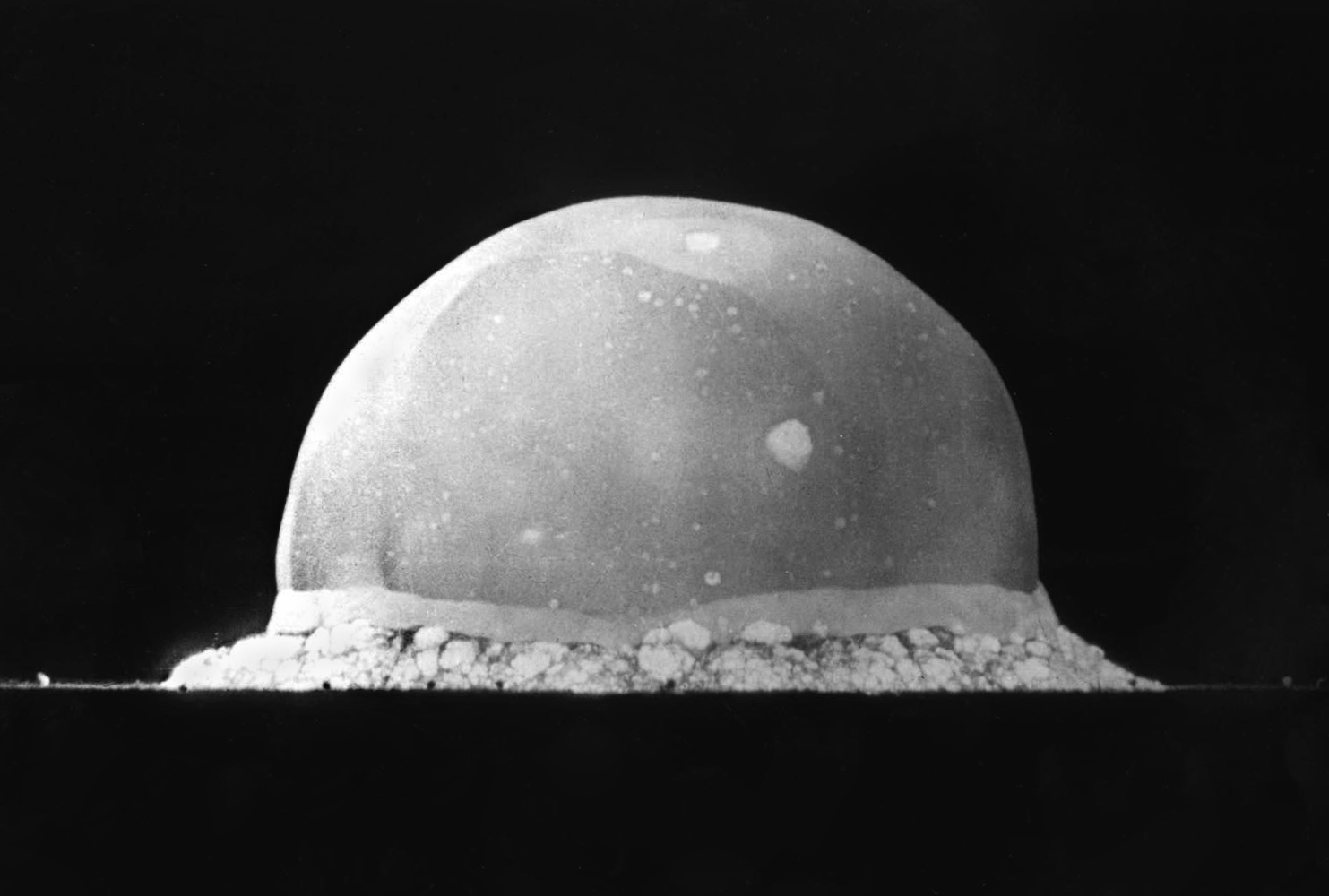
| DescripcióTrinity Test Fireball 16ms.jpg |
English: PA-98-0520 — Trinity Site explosion, 0.016 second after explosion, July 16, 1945. The viewed hemisphere's highest point in this image is about 200 meters high.
Türkçe: 16 Temmuz 1945 yılında New Mexico'daki Socorro'nın 56 km kadar güneydoğusunda şu an üzerinde komuta merkezi Alamogordo'da bulunan White Sands Missile Range'in bulunduğu yerde yapılmış Trinity patlamasının, infilak anından 0,016 sn sonra çekilmiş görüntüsüdür. Görüntülenen yarım kürenin en yüksek noktası yaklaşık 200 metre yüksekliğindedir.
Deutsch: Foto des Trinity-Tests, 16ms nach der Zündung am 16. Juli 1945. Die im Bild sichtbaren Feuerblase hat zu diesem Zeitpunkt eine Höhe von ca. 200 Metern. |
|||||||
| Data | ||||||||
| Font | http://www.lanl.gov/orgs/pa/photos/images/PA-98-0520.jpeg | |||||||
| Autor | Berlyn Brixner / Los Alamos National Laboratory | |||||||
| Permís (Com reutilitzar aquest fitxer) |
|
|||||||

| Posició de la càmera | 33° 40′ 39,24″ N, 106° 28′ 31,96″ O | Aquesta i altres imatges properes a: OpenStreetMap |
|---|
Llegendes
Afegeix una explicació d'una línia del que representa aquest fitxer
Trinity Site Explosion, 0.016 seconds after explosion, July 16, 1945
Foto des Trinity-Tests, 16ms nach der Zündung am 16. Juli 1945. Die im Bild sichtbaren Feuerblase hat zu diesem Zeitpunkt eine Höhe von ca. 200 Metern.
Trinity-ydinkokeen tulipallo alkuvaiheessaan 16. heinäkuuta 1945.
Elements representats en aquest fitxer
representa l'entitat
Trinity Site anglès
16 jul 1945
33°40'39.245"N, 106°28'31.958"W
image/jpeg
Historial del fitxer
Cliqueu una data/hora per veure el fitxer tal com era aleshores.
| Data/hora | Miniatura | Dimensions | Usuari/a | Comentari | |
|---|---|---|---|---|---|
| actual | 04:13, 8 juny 2008 | | 1.483 × 1.000 (215 Ko) | File Upload Bot (Magnus Manske) | {{BotMoveToCommons|en.wikipedia}} {{Information |Description={{en|PA-98-0520 -- Trinity Site explosion, .016 seconds after explosion, July 16, 1945. :URL: http://www.lanl.gov/orgs/pa/photos/images/PA-98-0520.jpeg :Photo Credit: Los Alamos National Labora |
Ús del fitxer
La pàgina següent utilitza aquest fitxer:
Ús global del fitxer
Utilització d'aquest fitxer en altres wikis:
- Utilització a ab.wikipedia.org
- Utilització a ar.wikipedia.org
- Utilització a arz.wikipedia.org
- Utilització a bcl.wikipedia.org
- Utilització a be-tarask.wikipedia.org
- Utilització a ce.wikipedia.org
- Utilització a cs.wikipedia.org
- Utilització a cv.wikipedia.org
- Utilització a de.wikipedia.org
- Utilització a el.wikipedia.org
- Utilització a en.wikipedia.org
- Los Alamos National Laboratory
- White Sands Missile Range
- Anthropocene
- List of states with nuclear weapons
- Wikipedia:Selected anniversaries/July 16
- Portal:United States/Selected picture
- Portal:History
- Berlyn Brixner
- Portal:History/Featured picture
- Portal:North America/Selected picture
- User talk:Tillman
- User:Tillman
- Portal:United States/Anniversaries/July
- Portal:United States/Anniversaries/All
- List of National Historic Landmarks in New Mexico
- Wikipedia:Featured pictures thumbs/11
- Wikipedia:Picture peer review/Archives/Apr-Jun 2008
- Wikipedia:Featured pictures/History/USA History
- Wikipedia:Featured picture candidates/May-2008
- Wikipedia:WikiProject United States Government
- Wikipedia:Picture peer review/Trinity explosion, 1945
- Wikipedia:Featured picture candidates/The Trinity nuclear test, 1945
Vegeu més usos globals d'aquest fitxer.