Kuthar
From Wikipedia, the free encyclopedia

Kuthar fou un estat tributari protegit del grup de les muntanyes Simla, al Panjab avui a Himachal Pradesh, a l'oest de Sabathu (campament militar britànmic comprat al sobirà), amb una superfície de 52 km² i una població el 1881 de 3.648 habitants i el 1901 de 4.195, repartida en 150 pobles o llogarets. Fou fundat per un rajput de nom Surat Chand, procedent de Rahaori o Rajaoli a Jammu, que fugia de la invasió musulmana. El 1803 fou ocupat pels gurkhes però el 1815 fou restaurat pels britànics que van concedir un sanad al sobirà. El rana Jagit Chand va pujar al tron el 1895 i era suposadament el 48è sobirà; com que era menor la regència fou confiada a Mian Shatrujit Singh, membre de la família Suket. Els ingressos eren de 1.100 lliures i pagava 10 lliures com a tribut.
| Localització | ||||
|---|---|---|---|---|
| ||||
| Dades històriques | ||||
| Creació | segle XVII | |||
| Dissolució | segle XIX | |||
| Següent | Índia | |||


Llista de ranes des del segle XVIII
- Samar Chand 1776-1791
- Gopal Chand 1791-1803 (fill)
- Ocupació gurkha 1803-1815
- Gopal Chand (segona vegada) 1815 - 1824
- Bhup Chand 1824-1858 (fill)
- Jai Chand 1858 - 1895 (fill)
- Jagjit Chand 1895 - 1930 (fill)
- Krishan Chand 1930 - 1949 (fill) (+1956)
Galeria
 A view 0f palace
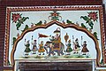 Wall painting ,Kuthar palace
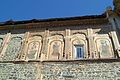 Architect of and art work of palace of Kuthar
- Architect of and art work of palace of Kuthar
 Art work on enterence of palace of Kuthar
 Art work on outer walls of palace of Kuthar
 Interior wall paintings on palace of Kuthar
 Interior art work on roof of Kuthar palace


Referències
- Wilson Hunter, Sir William; Sutherland Cotton, James; Sir Richard Burn, Sir William Stevenson Meyer. Great Britain India Office. The Imperial Gazetteer of India (en anglès). Oxford: Clarendon Press, 1908.
- Genealogia
Wikiwand in your browser!
Seamless Wikipedia browsing. On steroids.
Every time you click a link to Wikipedia, Wiktionary or Wikiquote in your browser's search results, it will show the modern Wikiwand interface.
Wikiwand extension is a five stars, simple, with minimum permission required to keep your browsing private, safe and transparent.