Račinský hřbet
hřeben v Gruzii From Wikipedia, the free encyclopedia
hřeben v Gruzii From Wikipedia, the free encyclopedia
Seamless Wikipedia browsing. On steroids.
Every time you click a link to Wikipedia, Wiktionary or Wikiquote in your browser's search results, it will show the modern Wikiwand interface.
Wikiwand extension is a five stars, simple, with minimum permission required to keep your browsing private, safe and transparent.
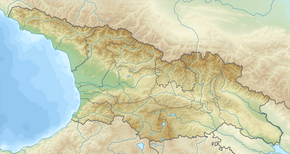
Račinský hřbet je horský hřbet v jižní části Velkého Kavkazu v Gruzii. Je tvořen převážně vápenci, porfyrity a tufogenními břidlicemi. Bohatě jsou zde rozvinuté krasové útvary (Šaorská kotlina – krasové pole přeměněné na vodní nádrž). Na svazích jsou listnaté lesy (hlavně bukové) i jehličnaté lesy, subalpské a alpské louky. U jihozápadních výběžků se nachází Tkibulské uhelné naleziště.
| Račinský hřbet რაჭის ქედი | |
|---|---|
 Račinský hřbet | |
| Nejvyšší bod | 2862 m n. m. (Lebeuris Mta) |
| Nadřazená jednotka | Velký Kavkaz |
| Světadíl | Asie |
| Stát | |
 Račinský hřbet | |
| Horniny | vápenec, porfyrit, tufogenní břidlice |
| Povodí | Rioni, Kura |
| Souřadnice | 42°28′23″ s. š., 43°27′43″ v. d. |
| Některá data mohou pocházet z datové položky. | |
Račinský hřbet dosahuje nadmořské výšky 2862 m. Na sever od hřbetu leží historická oblast Rača. Východní část je v Jižní Osetii. Na jihozápadě začíná Kolchidská nížina. Račinský hřbet odvodňují řeky: Kišelta, Cata a Velká Liachvi na východ a Džočiara, Džedžora a Rioni na západ.
V tomto článku byl použit překlad textu z článku Ratscha-Gebirge na německé Wikipedii.
