Datei:Nisyros.jpg
aus Wikipedia, der freien encyclopedia
Originaldatei (1.236 × 1.146 Pixel, Dateigröße: 169 KB, MIME-Typ: image/jpeg)
![]()
Diese Datei und die Informationen unter dem roten Trennstrich werden aus dem zentralen Medienarchiv Wikimedia Commons eingebunden.
![]()
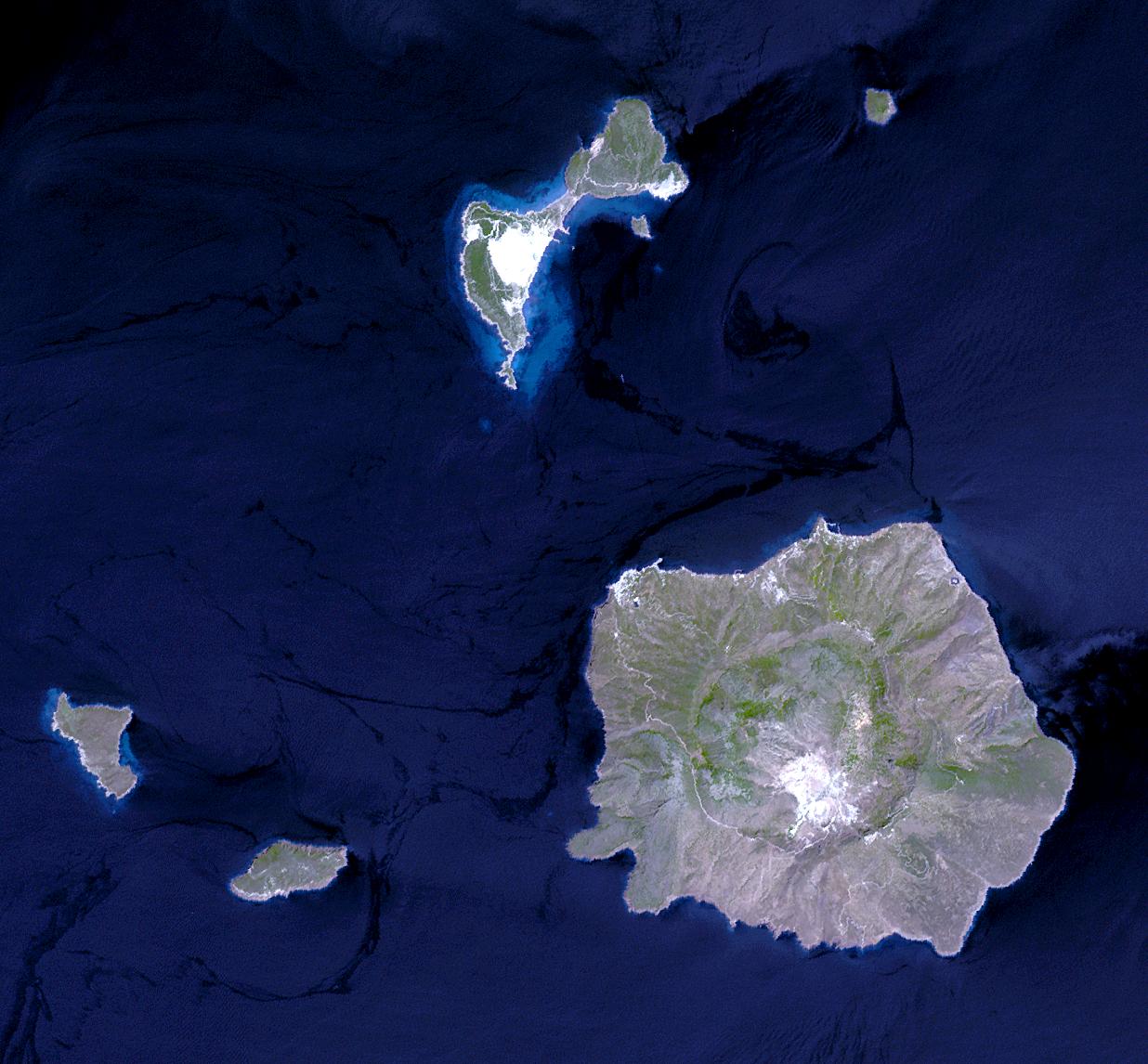
Nisyros Island, Aegean Sea (JPG) (173,039 bytes) ( 1,236 x 1,146 ) Nisyros is an active volcano in the Eastern edge of the South Aegean volcanic arc. It covers an area of 41.2 square kilometers and reaches a height of 698 meters. It is surrounded by 4 other small uninhabited volcanic islets. Nisyros is the youngest volcanic cone in the Aegean. Major volcanic activity is roughly estimated to have ended about 30,000 - 15,000 years ago. Since then superheated geothermal fluids triggered hydrothermal explosions, blasting the covering formations. Ten impressive craters of hydrothermal explosions with a diameter up to 300 m decorate the southeast part of the caldera floor. The most recent was created in 1887. This simulated natural color ASTER image is centered near 36.6 degrees north longitude, 27.2 degrees east latitude, covers an area of 18.5 x 17.2 km, and was acquired on July 29, 2004.
Please give credit for these images to: NASA/GSFC/METI/ERSDAC/JAROS, and U.S./Japan ASTER Science Team
| Public domainPublic domainfalsefalse |
| Diese Datei ist gemeinfrei (public domain), da sie von der NASA erstellt worden ist. Die NASA-Urheberrechtsrichtlinie besagt, dass „NASA-Material nicht durch Urheberrecht geschützt ist, wenn es nicht anders angegeben ist“. (NASA-Urheberrechtsrichtlinie-Seite oder JPL Image Use Policy). | ||
 |
Warnung:
|
Kurzbeschreibungen
In dieser Datei abgebildete Objekte
Motiv
Dateiversionen
Klicke auf einen Zeitpunkt, um diese Version zu laden.
| Version vom | Vorschaubild | Maße | Benutzer | Kommentar | |
|---|---|---|---|---|---|
| aktuell | 00:33, 1. Jun. 2005 | | 1.236 × 1.146 (169 KB) | Fxer~commonswiki | [http://asterweb.jpl.nasa.gov/gallery-detail.asp?name=nisyros Nisyros Island, Aegean Sea] (JPG) (173,039 bytes) ( 1,236 x 1,146 ) Nisyros is an active volcano in the Eastern edge of the South Aegean volcanic arc. It covers an area of 41.2 square kilometer |
Dateiverwendung
Die folgenden 5 Seiten verwenden diese Datei:
Globale Dateiverwendung
Die nachfolgenden anderen Wikis verwenden diese Datei:
- Verwendung auf ab.wikipedia.org
- Verwendung auf be.wikipedia.org
- Verwendung auf bg.wikipedia.org
- Verwendung auf ca.wikipedia.org
- Verwendung auf ceb.wikipedia.org
- Verwendung auf el.wikipedia.org
- Verwendung auf en.wikipedia.org
- Verwendung auf es.wikipedia.org
- Verwendung auf fi.wikipedia.org
- Verwendung auf fr.wikipedia.org
- Verwendung auf gl.wikipedia.org
- Verwendung auf he.wikipedia.org
- Verwendung auf hr.wikipedia.org
- Verwendung auf hy.wikipedia.org
- Verwendung auf hyw.wikipedia.org
- Verwendung auf it.wikipedia.org
- Verwendung auf la.wikipedia.org
- Verwendung auf nl.wikipedia.org
- Verwendung auf nn.wikipedia.org
- Verwendung auf no.wikipedia.org
- Verwendung auf pl.wikipedia.org
- Verwendung auf pt.wikipedia.org
- Verwendung auf ru.wikipedia.org
- Verwendung auf uk.wikipedia.org
- Verwendung auf www.wikidata.org
- Verwendung auf zh.wikipedia.org
Metadaten
Diese Datei enthält weitere Informationen (beispielsweise Exif-Metadaten), die in der Regel von der Digitalkamera oder dem verwendeten Scanner stammen. Durch nachträgliche Bearbeitung der Originaldatei können einige Details verändert worden sein.
| _error | 0 |
|---|