Dosya:Sakarya_districts.png
From Wikipedia, the free encyclopedia
Vervênayışê ebadê: 778 × 600 piksel. Agoznayışê bini: 311 × 240 piksel | 623 × 480 piksel | 996 × 768 piksel | 1,053 × 812 piksel.
Ebato oricinale (1,053 × 812 pikselan, ebatê dosya: 88 KB, MIME tipê cı: image/png)
| Na dosya depoyê Wikimedia Commons de esta u terefê proceyanê binan ra gureniyena. Cêr dê şınasiya dosyay pela mocniyeno. |
Xulasa
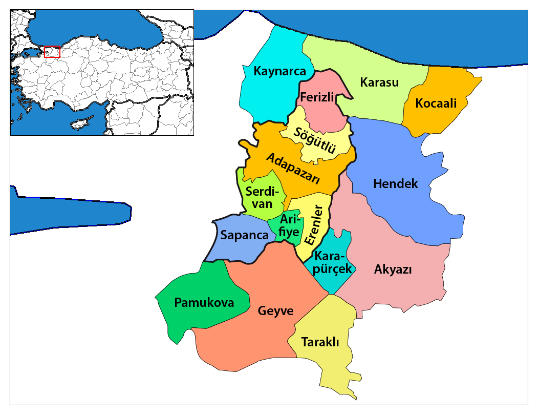
| ŞınasnayışSakarya districts.png | Map of the districts of Sakarya province in Turkey. Created by Rarelibra 17:12, 4 December 2006 (UTC) for public domain use, using MapInfo Professional v8.5 and various mapping resources. Edited by One Homo Sapiens Corrected text where İ,Ş,ı,ğ,or ş occurs in name. Source: [statoids-com]. Increased font size and enhanced color differences among adjacent districts. |
| Tarix | 4 Kanun 2006 (original upload date) |
| Çıme | No machine-readable source provided. Own work assumed (based on copyright claims). |
| Nuştekar | No machine-readable author provided. Rarelibra assumed (based on copyright claims). |
Lisans
| Public domainPublic domainfalsefalse |
| Ez, Wêrê ena teliferê, nê kari Malê şarideye ezo heserena. Dınya heme ca dı ravêreno. Tay dewletan dı no kanuniyey heta mıkum nêbone; o haldı: Ez, ena karer qande herhangi yew amaci, be şert, hendı ke legali icab nikeni, şari hemi re ezo mısade dana. |
Captions
Add a one-line explanation of what this file represents
Sakarya haritası
Items portrayed in this file
Dewrê mocnayışi
Verêniya dosya
Seba diyayışê viyarteyê dosya ra tarixê ke qısımê tarix/zemani derê inan bıtıkne.
| Tarix/Zeman | Resımo qıckek | Ebadi | Karber | Mışewre | |
|---|---|---|---|---|---|
| nıkayên | 18:47, 19 Çele 2014 | | 1,053 - 812 (88 KB) | Chumwa | Nach der letzten Gebietsreform ist der zentrale Landkreis (in der Karte zuvor "Sakarya Merkez") aufgeteilt worden in: Adapazarı, Arifiye, Erenler und Serdivan. Die Kreise, die zur Großstadtkommune Sakarya gehören, sind umrandet worden. |
| 01:58, 29 Kanun 2008 |  | 1,056 - 816 (33 KB) | One Homo Sapiens | Corrected text where İ,Ş,ı,ğ,or ş occurs in name. Source: [statoids-com]. Increased font size and enhanced color differences among adjacent districts. | |
| 16:00, 12 Nisane 2007 |  | 776 - 600 (110 KB) | KureCewlik81 | ||
| 17:12, 4 Kanun 2006 |  | 1,056 - 816 (34 KB) | Rarelibra | Map of the districts of Sakarya province in Turkey. Created by ~~~~ for public domain use, using MapInfo Professional v8.5 and various mapping resources. |
Gurenayışê dosya
The following pages link to this file:
Gurenayışê dosyaya gılovere
Ena dosya wikiyanê binan de gureniyena.
- ar.wikipedia.org sero guriyayış
- arz.wikipedia.org sero guriyayış
- ast.wikipedia.org sero guriyayış
- azb.wikipedia.org sero guriyayış
- az.wikipedia.org sero guriyayış
- be.wikipedia.org sero guriyayış
- ca.wikipedia.org sero guriyayış
- ceb.wikipedia.org sero guriyayış
- ce.wikipedia.org sero guriyayış
- cs.wikipedia.org sero guriyayış
- cv.wikipedia.org sero guriyayış
- de.wikipedia.org sero guriyayış
- en.wikipedia.org sero guriyayış
Yê na dosya gurenayışê gıloveri tayêna bıvêne.
Metadata
This file contains additional information, probably added from the digital camera or scanner used to create or digitize it. If the file has been modified from its original state, some details may not fully reflect the modified image.
| Qerarê verıniye | 37.8 dpc |
|---|---|
| Rezulasyanê derganiye | 37.8 dpc |
| Karenaye nusnerek |
|
Retrieved from "https://diq.wikipedia.org/wiki/Dosya:Sakarya_districts.png"