
ཨའིསི་ལེནཌ
From Wikipedia, the free encyclopedia
ཨའིསི་ལེནཌ
| Please translate this article into Dzongkha or check its translation. Please translate this template into Dzongkha (e) |

 Combined satellite image of Iceland
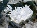 NASA satellite image of Iceland
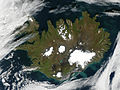 Iceland on September 9 2002
 Iceland, the Faroes and Hebrides.
 Grímsvötn eruption Nov. 2004
 A map of Iceland with major geographical features marked
 Iceland between Scandinavia, British Islands, and Greenland
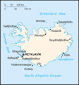 CIA Factbook map of Iceland
 Historical map of Iceland (1888)
 Mid-Atlantic Rigde
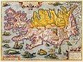 Iceland in 1590, Ortelius


| Please translate this article into Dzongkha or check its translation. Please translate this template into Dzongkha (e) |
| This article is a stub. You can help Wikipedia by expanding it. Please translate this template into Dzongkha (e) |