Αρχείο:Cities_of_Tierra_del_Fuego.png
From Wikipedia, the free encyclopedia
Δεν διατίθεται υψηλότερη ανάλυση.
Cities_of_Tierra_del_Fuego.png (519 × 475 εικονοστοιχεία, μέγεθος αρχείου: 21 KB, τύπος MIME: image/png)
|
|
Αυτό το αρχείο και η περιγραφή του προέρχονται από το Wikimedia Commons. Οι πληροφορίες από την σελίδα περιγραφής του εκεί εμφανίζονται παρακάτω. |
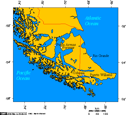
English: Cities of Tierra del Fuego
Esperanto: Urboj de Fuegio
Español: Ciudades de Tierra del Fuego

|
Παραχωρείται η άδεια προς αντιγραφή, διανομή και/ή τροποποίηση αυτού του εγγράφου υπό τους όρους της Άδειας Ελεύθερης Τεκμηρίωσης GNU, Έκδοση 1.2 ή οποιασδήποτε νεότερης έκδοσης δημοσιευμένης από το Ίδρυμα Ελεύθερου Λογισμικού· χωρίς Απαράλαχτους Τομείς, χωρίς Κείμενα Εξωφύλλου, και χωρίς Κείμενα Οπισθοφύλλου. Αντίγραφο της άδειας περιλαμβάνεται στην σελίδα με τίτλο GNU Free Documentation License.http://www.gnu.org/copyleft/fdl.htmlGFDLGNU Free Documentation Licensetruetrue |
| Το αρχείο διανέμεται υπό την άδεια Creative Commons Αναφορά προέλευσης-Παρόμοια διανομή 3.0 Μη εισαγόμενη | ||
| ||
| Αυτή η ετικέτα άδειας χρήσης προστέθηκε στο αρχείο ως μέρους της αναθεώρησης της άδειας GFDL .http://creativecommons.org/licenses/by-sa/3.0/CC BY-SA 3.0Creative Commons Attribution-Share Alike 3.0truetrue |
This map is taken from en:Image:Cities of Tierra del Fuego.png and was created with this online map creation tool archive copy at the Wayback Machine. Uploaded by en:User:Geo Swan on 14 March 2005.
The longitude and latitude of the cities follow:
- -70.9333,-53.1666,Punta Arenas
- -70.3648,-53.2959,Porvenir
- -67.6167,-54.9333,Puerto Williams
- -68.2978,-54.7921,Ushuaia
- -67.5982,-53.8114,Rio Grande
Λεζάντες
Δεν ορίστηκε λεζάντα
Items portrayed in this file
απεικονίζει
image/png
checksum Αγγλικά
7f57895f61db7b04ecb12ab8583660293de61268
data size Αγγλικά
21.750 Byte
475 εικονοστοιχείο
519 εικονοστοιχείο
Ιστορικό αρχείου
Κλικάρετε σε μια ημερομηνία/ώρα για να δείτε το αρχείο όπως εμφανιζόταν εκείνη τη στιγμή.
| Ώρα/Ημερομ. | Μικρογραφία | Διαστάσεις | Χρήστης | Σχόλια | |
|---|---|---|---|---|---|
| τελευταία | 11:47, 6 Οκτωβρίου 2005 | | 519 × 475 (21 KB) | ChongDae | This image was copied from wikipedia:en. The original description was: Cities of Tierra del Fuego {{GFDL}} This map was created with this [http://www.aquarius.geomar.de/omc/ online map creation tool]. The longitude and latitude of the cities follow: *- |
| 10:46, 24 Απριλίου 2005 |  | 519 × 475 (21 KB) | Poulpy | Cities of Tierra del Fuego {{GFDL}} This map is taken from en:Image:Cities of Tierra del Fuego.png and was created with this [http://www.aquarius.geomar.de/omc/ online map creation tool]. The longitude and latitude of the cities follow: *-70.9333,- |
Συνδέσεις αρχείου
Τα παρακάτω λήμματα συνδέουν σε αυτό το αρχείο:
Καθολική χρήση αρχείου
Τα ακόλουθα άλλα wiki χρησιμοποιούν αυτό το αρχείο:
- Χρήση σε ar.wikipedia.org
- Χρήση σε bg.wikipedia.org
- Χρήση σε ca.wikipedia.org
- Χρήση σε ckb.wikipedia.org
- Χρήση σε cs.wikipedia.org
- Χρήση σε da.wikipedia.org
- Χρήση σε de.wikipedia.org
- Χρήση σε en.wikipedia.org
- Χρήση σε eo.wikipedia.org
- Χρήση σε es.wikipedia.org
- Χρήση σε fa.wikipedia.org
- Χρήση σε fr.wikipedia.org
- Χρήση σε fy.wikipedia.org
- Χρήση σε gd.wikipedia.org
- Χρήση σε hr.wikipedia.org
- Χρήση σε id.wikipedia.org
- Χρήση σε it.wikipedia.org
- Χρήση σε ja.wikipedia.org
- Χρήση σε ka.wikipedia.org
- Χρήση σε ko.wikipedia.org
- Χρήση σε la.wikipedia.org
- Χρήση σε lt.wikipedia.org
- Χρήση σε mk.wikipedia.org
- Χρήση σε ml.wikipedia.org
- Χρήση σε nl.wikipedia.org
- Χρήση σε no.wikipedia.org
- Χρήση σε pl.wikipedia.org
- Χρήση σε pl.wiktionary.org
- Χρήση σε pt.wikipedia.org
- Χρήση σε ro.wikipedia.org
Δείτε περισσότερη καθολική χρήση αυτού του αρχείου.
Ανακτήθηκε από "https://el.wikipedia.org/wiki/Αρχείο:Cities_of_Tierra_del_Fuego.png"