The BR-267 is a Brazilian federal highway that crosses the Brazilian states of Minas Gerais, São Paulo and Mato Grosso do Sul.
 | |
|---|---|
 | |
| Route information | |
| Length | 1,921.3 km (1,193.8 mi) |
| Major junctions | |
| East end | BR-116 in Leopoldina |
| West end | Brazil–Paraguay border in Porto Murtinho |
| Location | |
| Country | Brazil |
| Highway system | |
It originates in the municipality of Leopoldina, Minas Gerais, at the junction with Highway BR-116 and continues to the Brazil–Paraguay border in Porto Murtinho, Mato Grosso do Sul.[1]
BR-267 has a total length of 1,922 km (1,194 mi), 533 in Minas Gerais, 706 in São Paulo and 683 in Mato Grosso do Sul. In Minas Gerais, on the stretch between Juiz de Fora and Poços de Caldas, it is called Rodovia Vital Brazil, with a project to change it to Rodovia Presidente Itamar Franco.[2][3]
Gallery
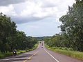 BR-267 between Bataguassu and Campo Grande.
 BR-267 in Campestre, Minas Gerais
 BR-267 in Olaria, Minas Gerais
 BR-267 in Aiuruoca, Minas Gerais


References
Wikiwand in your browser!
Seamless Wikipedia browsing. On steroids.
Every time you click a link to Wikipedia, Wiktionary or Wikiquote in your browser's search results, it will show the modern Wikiwand interface.
Wikiwand extension is a five stars, simple, with minimum permission required to keep your browsing private, safe and transparent.