Bonnievale, South Africa
Place in Western Cape, South Africa From Wikipedia, the free encyclopedia

Bonnievale is a settlement in the Cape Winelands District Municipality in the Western Cape province of South Africa.
Bonnievale | |
|---|---|
 Church street in Bonnievale | |
 Bonnievale  Bonnievale | |
| Coordinates: 33°55′39″S 20°6′2″E | |
| Country | South Africa |
| Province | Western Cape |
| District | Cape Winelands |
| Municipality | Langeberg |
| Area | |
| • Total | 27.07 km2 (10.45 sq mi) |
| Population (2011)[1] | |
| • Total | 9,092 |
| • Density | 340/km2 (870/sq mi) |
| Racial makeup (2011) | |
| • Black African | 11.1% |
| • Coloured | 75.3% |
| • Indian/Asian | 0.2% |
| • White | 10.7% |
| • Other | 2.7% |
| First languages (2011) | |
| • Afrikaans | 89.7% |
| • Xhosa | 6.0% |
| • English | 1.7% |
| • Sotho | 1.3% |
| • Other | 1.3% |
| Time zone | UTC+2 (SAST) |
| Postal code (street) | 6730 |
| PO box | 6730 |
| Area code | 023 |
The town is 64 km southeast of Worcester, in the Breede River Valley. It was founded in 1922, and was named after the railway siding called Vale at its opening in 1902 and Bonnie Vale in 1917. Municipal status was gained in April 1953.[2] Bonnievale is surrounded by the Langeberge and Riversonderend Mountains. Situated on the Cape Wine Route, the area caters to tourists[3] with locally made cheese and wine, along with private game reserves and extensive hiking trails.[4]
Gallery
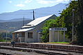 Old station building, 1922–2012
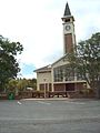 NG Church, built c. 1922
 DJ le Roux Museum
 Weltevrede vineyards


References
Wikiwand in your browser!
Seamless Wikipedia browsing. On steroids.
Every time you click a link to Wikipedia, Wiktionary or Wikiquote in your browser's search results, it will show the modern Wikiwand interface.
Wikiwand extension is a five stars, simple, with minimum permission required to keep your browsing private, safe and transparent.