Elephantine
Island in the Nile From Wikipedia, the free encyclopedia

Elephantine (/ˌɛlɪfænˈtaɪniː, -ˈtiː-/ EL-if-an-TY-nee, -TEE-;[2] Ancient Egyptian: 𓍋𓃀𓅱𓃰, romanized: ꜣbw; Egyptian Arabic: جزيرة الفنتين; Greek: Ἐλεφαντίνη Elephantíne; Coptic: (Ⲉ)ⲓⲏⲃ (e)iēb, Coptic pronunciation: [jæb]) is an island on the Nile, forming part of the city of Aswan in Upper Egypt. The archaeological digs on the island became a World Heritage Site in 1979, along with other examples of Upper Egyptian architecture, as part of the "Nubian Monuments from Abu Simbel to Philae" (despite Elephantine being neither Nubian, nor between Abu Simbel and Philae).[3]
Native name: جزيرة فيلة (Ⲉ)ⲓⲏⲃ 𓍋𓃀𓅱𓃰 | |
|---|---|
 West bank of Elephantine Island on the Nile | |
 Elephantine Location in the Nile at Aswan, Upper Egypt | |
| Geography | |
| Coordinates | 24.09°N 32.89°E |
| Adjacent to | Nile |
| Length | 1,200 m (3900 ft) |
| Width | 400 m (1300 ft) |
| Administration | |
Egypt | |
| 3bw 𓍋𓃀𓅱𓃰 "Elephantine"[1] in hieroglyphs | |||||
|---|---|---|---|---|---|

The island has been studied through excavation sites. Aramaic papyri and ostraca have been collected to study what life was like on Elephantine during the time of ancient Egypt. There have been studies about the Elephantine Triad and the Jewish presence that formulated on the island.[4] The standard reference collection of the Aramaic documents of the Elephantine Papyri and Ostraca is the Textbook of Aramaic Documents from Ancient Egypt.[5]
Geography
Elephantine, or what ancient Egyptians called Yebu or Abu is located at the uppermost part of the Nile river that is a part of Aswan.[6] Elephantine had the first nome of the northern part of Egypt.[4] Elephantine is 1,600 metres from north to south and 450 metres across at its widest point.[7] The layout of this and other nearby islands in Aswan can be seen from west bank hillsides along the Nile. The island is located just downstream of the First Cataract, at the southern border of Upper Egypt with Lower Nubia. This region above is called Upper Egypt because it is further up the Nile.[4]
The island may have received its name after its shape, which in aerial views is similar to that of an elephant tusk, or from the rounded rocks along the banks resembling elephants.[8]
Ancient Egypt
Known to the ancient Egyptians as ꜣbw "Elephant" (Middle Egyptian: /ˈʀuːbaw/ → Medio-Late Egyptian: /ˈjuːbəʔ/ → Coptic: (Ⲉ)ⲓⲏⲃ /ˈjeβ/, preserved in its Hebrew name, יֵב Yēḇ), the island of Elephantine stood at the border between Egypt and Nubia. Trade routes would stop on Elephantine to deliver ivory, a precious good in ancient Egypt.[4] It was an excellent defensive site for a fort, and its location made it a natural cargo transfer point for river trade. During the Second Intermediate Period (1650–1550 BC), the fort marked the southern border of Egypt.[9] The island was also a vital stone quarry, providing granite for monuments and buildings all over Egypt.
Historical texts from the Middle Kingdom of Egypt mention the mother of Amenemhat I, founder of the Twelfth Dynasty, being from[10] the Elephantine Egyptian nome Ta-Seti.[11][12][13] Many scholars have argued that Amenemhat I's mother was of Nubian origin.[14][15][16][17][18][19][20][21]
Archaeological sites
Between 1893 and 1910, Aramaic papyri, consisting of Jewish achievements, were found and collected on Elephantine. There has been a large presence of German excavation with a vast amount of discoveries or papyri and ostraca.[22] The documents have led to discoveries about Jewish presence and significance in Elephantine.[8][23] French teams also set out to Elephantine where they discovered several hundred ostraca, but very few have been published thus far.[22][7] The major findings from the end of the 19th century to the beginning of the 20th century are found in these museums; Berlin, Brooklyn, Cairo, London, Munich, and Paris.[24]
Ongoing excavations by the German Archaeological Institute at the town have uncovered many findings, on display in the Aswan Museum located on the island, including a mummified ram of Khnum. Artifacts dating back to prehistoric Egypt have been found on Elephantine. A rare calendar, known as the Elephantine Calendar of Things, which dates to the reign of Thutmose III during the Eighteenth Dynasty, was found in fragments on the island.
Temples
Prior to 1822, there were temples to Thutmose III and Amenhotep III[25] on the island. In 1822, they were destroyed during the campaign of Muhammad Ali, who had taken power in Egypt, to conquer Sudan.

The main two temples of the island were for Satet and Khnum.[7] The first temple was the temple of Satet, founded around 3000 BC and enlarged and renovated over the next 3,000 years. There are records of an Egyptian temple to Khnum on the island as early as the Third Dynasty. This temple was completely rebuilt in the Late Period, during the Thirtieth Dynasty of Egypt, just before the foreign rule that followed in the Graeco-Roman Period. The Greeks formed the Ptolemaic dynasty during their 300-year rule over Egypt (305–30 BC) and maintained the ancient religious customs and traditions, while often associating the Egyptian deities with their own.

Most of the present day southern tip of the island is taken up by the ruins of the temple of Khnum. These, the oldest ruins still standing on the island, are composed of a granite step pyramid from the Third Dynasty and a small temple built for the local Sixth Dynasty nomarch, Heqaib. In the Middle Kingdom, many officials, such as the local governors Sarenput I or Heqaib III, dedicated statues and shrines into the temple.


Nilometers
A nilometer was a structure for measuring the Nile River's clarity and the water level during the annual flood season. There are two nilometers at Elephantine.[4] The more famous is a corridor nilometer associated with the temple of Satis, with a stone staircase that descends the corridor.[4] It is one of the oldest nilometers in Egypt, last reconstructed in Roman times and still in use as late as the 19th century AD. Ninety steps that lead down to the river are marked with Arabic, Roman, and hieroglyphic numerals. Visible at the water's edge are inscriptions carved deeply into the rock during the Seventeenth Dynasty.
The other nilometer is a rectangular basin located at the island's southern tip, near the temple of Khnum and opposite the Old Cataract Hotel. It is probably the older of the two. One of the nilometers, though it is not certain which, is mentioned by the Greek historian Strabo.
Many sources claim that the fabled "Well of Eratosthenes", famous in connection with Eratosthenes' presumed calculation of the Earth's circumference, was located on the island. Strabo mentions a well that was used to observe that Aswan lies on the Tropic of Cancer, but the reference is to a well at Aswan, not at Elephantine. Neither nilometer at Elephantine is suitable for the purpose, while the well at Aswan is apparently lost.[26]
Elephantine triad
The Elephantine triad is between Khnum, Satis, and Anuket, it is debated whether Anuket is the daughter of the two or the sister of Satis.[4][27] Elephantine was the dwelling place of Khnum, the ram-headed god of the cataracts, who guarded and controlled the waters of the Nile from caves beneath the island.[4]
Satis was worshipped from very early times as a war goddess and protector of this strategic region of Egypt. When seen as a fertility goddess, she personified the bountiful annual flooding of the Nile. The cult of Satis originated in Aswan. Later, when the triad was formed, Khnum became identified as her consort and, thereby, was thought of as the father of Anuket. His role in myths later changed; another deity was ascribed duties with the river. At that time his role as a potter enabled him to be assigned a duty in the creation of human bodies. Anuket was the goddess of the first cataract and is referred to as the personification of the Nile.[4] A cult was formed on the island for Anuket.[27]
Jewish presence
The Elephantine papyri and ostraca are caches of legal documents and letters written in Imperial Aramaic dating to sometime in the 5th century BC.[28][29] These papyri document the presence of a community of Judean mercenaries and their families on Elephantine, starting in the 7th century BCE. The mercenaries guarded the frontier between Egypt and Nubia.[30][31] Following the 587 BCE destruction of Jerusalem, some Judean refugees traveled south and, in what may be called an “exodus in reverse,” settled on Elephantine. They maintained their own temple (the House of Yahweh) in which sacrifices were offered, evincing polytheistic beliefs, which functioned alongside that of Khnum.[32] It is not clear when or why the Jewish community settled in Elephantine.[6] The temple may have been built in reaction to Manasseh's reinstitution of pagan worship or simply to serve the needs of the Jewish community.[28]
Conflict Between Jews and Egyptians
There is bias that surrounds the Jewish and Egyptian interactions that occurred on Elephantine, but the findings show that there was often culture interchange.[6] Conflict began after an Egyptian precious stone turned up in the hands of the Jews.[33]
The earliest recount of the Jewish temple is from 525 BC.[34] In 410 BC, the Jewish temple, the House of Yahweh, was burned down by a Persian military commander after he was bribed by Khnum priests.[4][24][8] While no explicit reasoning has been given for this lash out, it has been suspected that the priests did this because of the Jewish rituals of sacrificing of sheep, especially during Passover.[8] Papyri records that have been collected from this time show Jewish letters asking Bagoas for help rebuilding the temple.[8]
The standard reference collection of the Aramaic documents of the Elephantine papyri and ostraca is the Textbook of Aramaic Documents from Ancient Egypt.[35]
Other features
The Aswan Museum is located at the southern end of the island. Ongoing excavations by the German Archaeological Institute at the island's ancient town site have uncovered many findings that are now on display in the museum, including a mummified ram of Khnum. A sizable population of Nubians live in three villages in the island's middle section. A large luxury hotel is at the island's northern end.
The Aswan Botanical Garden is adjacent to the west on el Nabatat Island.
Primary scholarly documents
- Arthur Ungnad, Aramäische Papyrus aus Elephantine
- Eduard Sachau, 1908, Drei aramäische papyrusurkunden aus Elephantine
- Eduard Sachau, 1911, Aramäische Papyrus und Ostraka aus einer jüdischen Militär-Kolonie zu Elephantine
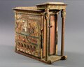 Votive naos with sledge and pronaos supported by hathoric columns, dedicated by the artisan Kasa to the Elephantine Triad. Museo Egizio, Turin.

Gallery
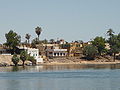 Nubian houses on central Elephantine Island
 Verdant Elephantine Island, opposite Assuan, Egypt", 1908. Lantern slide. Brooklyn Museum
 Island of Elephantine, by Edwin Howland Blashfield. Brooklyn Museum
 Ruins on Elephantine Island in 2000


_-_Edwin_Howland_Blashfield_-_overall.jpg)

See also
Wikimedia Commons has media related to Elephantine.
References
Further reading
Wikiwand in your browser!
Seamless Wikipedia browsing. On steroids.
Every time you click a link to Wikipedia, Wiktionary or Wikiquote in your browser's search results, it will show the modern Wikiwand interface.
Wikiwand extension is a five stars, simple, with minimum permission required to keep your browsing private, safe and transparent.