File:Bcamazonica.jpg
From Wikipedia, the free encyclopedia
No higher resolution available.
Bcamazonica.jpg (800 × 578 pixels, file size: 260 KB, MIME type: image/jpeg)
| This is a file from the Wikimedia Commons. Information from its description page there is shown below. Commons is a freely licensed media file repository. You can help. |

|
This map image could be re-created using vector graphics as an SVG file. This has several advantages; see Commons:Media for cleanup for more information. If an SVG form of this image is available, please upload it and afterwards replace this template with
{{vector version available|new image name}}.
It is recommended to name the SVG file “Bcamazonica.svg”—then the template Vector version available (or Vva) does not need the new image name parameter. |
 | This map image was uploaded in the JPEG format even though it consists of non-photographic data. This information could be stored more efficiently or accurately in the PNG or SVG format. If possible, please upload a PNG or SVG version of this image without compression artifacts, derived from a non-JPEG source (or with existing artifacts removed). After doing so, please tag the JPEG version with {{Superseded|NewImage.ext}} and remove this tag. This tag should not be applied to photographs or scans. If this image is a diagram or other image suitable for vectorisation, please tag this image with {{Convert to SVG}} instead of {{BadJPEG}}. If not suitable for vectorisation, use {{Convert to PNG}}. For more information, see {{BadJPEG}}. |  |
| DescriptionBcamazonica.jpg |
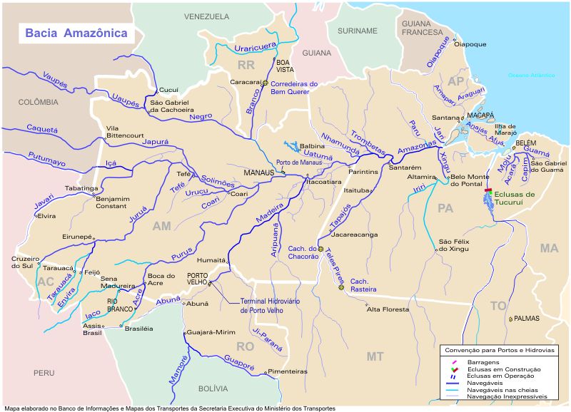
Português: O mapa mostra a região hidrográfica do Amazonas
English: Map showing the Amazonas watershed |
||||
| Source | https://web.archive.org/web/20090620080103/http://www.transportes.gov.br/bit/mapas/mapclick/hidro/bcamaz.htm | ||||
| Author | Secretaria Executiva do Ministério dos Transportes | ||||
| Permission (Reusing this file) |
|
||||
| Other versions |
|


Captions
Add a one-line explanation of what this file represents
Items portrayed in this file
depicts
image/jpeg
8755e9684749a46896e7fdf10884d9bf509e7977
266,360 byte
578 pixel
800 pixel
File history
Click on a date/time to view the file as it appeared at that time.
| Date/Time | Thumbnail | Dimensions | User | Comment | |
|---|---|---|---|---|---|
| current | 18:19, 18 April 2005 | | 800 × 578 (260 KB) | Santana-freitas~commonswiki | Região Hidrográfica do Amazonas |
File usage
The following pages on the English Wikipedia use this file (pages on other projects are not listed):
Global file usage
The following other wikis use this file:
- Usage on af.wikipedia.org
- Usage on ar.wikipedia.org
- Usage on arz.wikipedia.org
- Usage on azb.wikipedia.org
- Usage on be.wikipedia.org
- Usage on br.wikipedia.org
- Usage on ca.wikipedia.org
- Usage on ceb.wikipedia.org
- Usage on de.wikipedia.org
- Usage on es.wikipedia.org
- Río Vaupés
- Río Tacutu
- Wikipedia:¿Sabías que.../enero de 2008
- Wikipedia:¿Sabías que.../4 de enero de 2008
- Usuario:Leandro10 3
- Usuario:Zero spartan
- Wikipedia:¿Sabías que.../1
- Wikipedia:¿Sabías que.../2
- Usuario:ElBeTa
- Wikipedia:¿Sabías que.../Todos
- Río Tefé
- Río Uatumã
- Río Coari
- Río Trombetas
- Río Nhamundá
- Río Paru
- Río Aripuanã
- Río Roosevelt
- Río Ji-Paraná
- Río Branco (Roraima)
- Río Uraricoera
- Wikipedia:¿Sabías que.../SQ
- Plantilla:SQ/1
- Usuario:Lobo/Taller/¿Sabías que.../SQ/1-100
- Wikipedia:¿Sabías que.../SQ/?
- Usage on eu.wikipedia.org
- Usage on fa.wikipedia.org
- Usage on fr.wikipedia.org
View more global usage of this file.
Metadata
This file contains additional information, probably added from the digital camera or scanner used to create or digitize it.
If the file has been modified from its original state, some details may not fully reflect the modified file.
| _error | 0 |
|---|
Retrieved from "https://en.wikipedia.org/wiki/File:Bcamazonica.jpg"