File:Επέκταση_Ελλάδας_1832-1947.svg
From Wikipedia, the free encyclopedia

Size of this PNG preview of this SVG file: 457 × 599 pixels. Other resolutions: 183 × 240 pixels | 366 × 480 pixels | 586 × 768 pixels | 781 × 1,024 pixels | 1,562 × 2,048 pixels | 734 × 962 pixels.
Original file (SVG file, nominally 734 × 962 pixels, file size: 107 KB)
| This is a file from the Wikimedia Commons. Information from its description page there is shown below. Commons is a freely licensed media file repository. You can help. |
Summary
| DescriptionΕπέκταση Ελλάδας 1832-1947.svg |
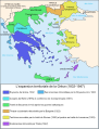
Čeština: Mapa zobrazuje územní expanzi Řeckého království (1832–1947). Dansk: Kort over Grækenlands territoriale udvidelser, 1832-1947. Deutsch: Territoriale Expansion Griechenlands 1832-1947. English: The territorial expansion of Greece, 1832-1947. Español: Mapa de la expansión territorial griega (1832-1947) Euskara: Greziaren lurralde hedapena 1832-1947 bitartean Français : L'expansion territoriale de la Grèce. 1832-1947. Hrvatski: Teritorijalno proširenje Grčke u razdoblju od 1832. do 1947. Italiano: L'espansione territoriale della Grecia dal 1832 al 1947 Magyar: Görögország területi növekedése (1832-1947) Occitan : Evolucions territòrialas de Grècia. Ελληνικά: Η εδαφική επέκταση της Ελλάδας 1832-1947. Македонски: Територијално проширување на Грција Українська: Територіальна експансія Греції (1832-1947). 日本語: ギリシャ王国の版図拡大 (1832-1947年) 中文: 希腊的领土变迁,1832年-1947年间。 العربية : خريطة تُصوِّر الأراضي التي استولت عليها اليونان مُنذُ سنة 1832م حين استقلالها عن الدولة العُثمانيَّة، وُصولًا إلى سنة 1947م |
||
| Date | |||
| Source | Translation of Image:Map Greece expansion 1832-1947-fr.svg | ||
| Author | Historicair for the map, Geraki for the translation | ||
| Other versions |
[edit]
|


.PNG)


.png)


Licensing

|
Permission is granted to copy, distribute and/or modify this document under the terms of the GNU Free Documentation License, Version 1.2 or any later version published by the Free Software Foundation; with no Invariant Sections, no Front-Cover Texts, and no Back-Cover Texts. A copy of the license is included in the section entitled GNU Free Documentation License.http://www.gnu.org/copyleft/fdl.htmlGFDLGNU Free Documentation Licensetruetrue |
| This file is licensed under the Creative Commons Attribution-Share Alike 3.0 Unported license. | ||
| ||
| This licensing tag was added to this file as part of the GFDL licensing update.http://creativecommons.org/licenses/by-sa/3.0/CC BY-SA 3.0Creative Commons Attribution-Share Alike 3.0truetrue |
Captions
Add a one-line explanation of what this file represents
Items portrayed in this file
depicts
28 December 2007
File history
Click on a date/time to view the file as it appeared at that time.
| Date/Time | Thumbnail | Dimensions | User | Comment | |
|---|---|---|---|---|---|
| current | 14:34, 29 August 2010 | | 734 × 962 (107 KB) | Sarah fides | Η Θεσσαλονίκη ήταν γραμμένη στα Γαλλικά (Thessalonique). |
| 16:19, 28 December 2007 |  | 734 × 962 (106 KB) | Geraki | {{Information |Description= {{el|Η εδαφική επέκταση της Ελλάδας 1832-1947.}} |Source= Translation of Image:Map Greece expansion 1832-1947-fr.svg |Date= 28 Dec 2007 |Author= User:Historicair for the map, User:Geraki |
File usage
No pages on the English Wikipedia use this file (pages on other projects are not listed).
Global file usage
The following other wikis use this file:
- Usage on az.wikipedia.org
- Usage on el.wikipedia.org
- Usage on ru.wikipedia.org
Retrieved from "https://en.wikipedia.org/wiki/File:Επέκταση_Ελλάδας_1832-1947.svg"