File:2.4b-Ingrian-and-Votic_current.png
From Wikipedia, the free encyclopedia
Size of this preview: 800 × 562 pixels. Other resolutions: 320 × 225 pixels | 640 × 449 pixels | 1,024 × 719 pixels | 1,280 × 899 pixels | 2,116 × 1,486 pixels.
Original file (2,116 × 1,486 pixels, file size: 261 KB, MIME type: image/png)
| This is a file from the Wikimedia Commons. Information from its description page there is shown below. Commons is a freely licensed media file repository. You can help. |
Summary
| Description2.4b-Ingrian-and-Votic current.png |
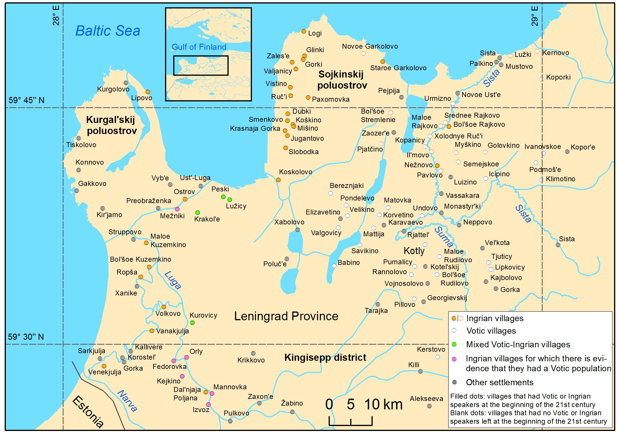
English: Ingrian and Votic villages at the beginning of the 21st century |
| Date | |
| Source | https://sites.utu.fi/urhia/language-maps/ |
| Author |
Rantanen, T., Tolvanen, H., Roose, M., Ylikoski, J. & Vesakoski, O. (2022) “Best practices for spatial language data harmonization, sharing and map creation – A case study of Uralic” PLoS ONE 17(6): e0269648. https://doi.org/10.1371/journal.pone.0269648. Rantanen, Timo, Vesakoski, Outi, Ylikoski, Jussi, & Tolvanen, Harri. (2021). Geographical database of the Uralic languages (v1.0) [Data set]. Zenodo. https://doi.org/10.5281/zenodo.4784188 |
Licensing
This file is licensed under the Creative Commons Attribution 4.0 International license.
- You are free:
- to share – to copy, distribute and transmit the work
- to remix – to adapt the work
- Under the following conditions:
- attribution – You must give appropriate credit, provide a link to the license, and indicate if changes were made. You may do so in any reasonable manner, but not in any way that suggests the licensor endorses you or your use.
Captions
Add a one-line explanation of what this file represents
Items portrayed in this file
depicts
21 December 2021
File history
Click on a date/time to view the file as it appeared at that time.
| Date/Time | Thumbnail | Dimensions | User | Comment | |
|---|---|---|---|---|---|
| current | 14:31, 27 January 2024 | | 2,116 × 1,486 (261 KB) | Jähmefyysikko | Uploaded a work by Rantanen, T., Tolvanen, H., Roose, M., Ylikoski, J. & Vesakoski, O. (2022) “Best practices for spatial language data harmonization, sharing and map creation – A case study of Uralic” PLoS ONE 17(6): e0269648. https://doi.org/10.1371/journal.pone.0269648. Rantanen, Timo, Vesakoski, Outi, Ylikoski, Jussi, & Tolvanen, Harri. (2021). Geographical database of the Uralic languages (v1.0) [Data set]. Zenodo. https://doi.org/10.5281/zenodo.4784188 from https://sites.utu.fi/urhia/l... |
File usage
The following pages on the English Wikipedia use this file (pages on other projects are not listed):
Metadata
This file contains additional information, probably added from the digital camera or scanner used to create or digitize it.
If the file has been modified from its original state, some details may not fully reflect the modified file.
| Horizontal resolution | 118.11 dpc |
|---|---|
| Vertical resolution | 118.11 dpc |