File:Abertridwr_Community_Centre_-_geograph.org.uk_-_2928663.jpg
From Wikipedia, the free encyclopedia
Size of this preview: 586 × 599 pixels. Other resolutions: 235 × 240 pixels | 626 × 640 pixels.
Original file (626 × 640 pixels, file size: 95 KB, MIME type: image/jpeg)
| This is a file from the Wikimedia Commons. Information from its description page there is shown below. Commons is a freely licensed media file repository. You can help. |
Summary
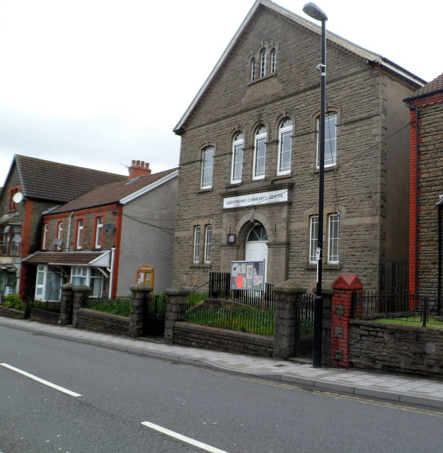
| DescriptionAbertridwr Community Centre - geograph.org.uk - 2928663.jpg |
English: Abertridwr Community Centre. Located on the north side of Thomas Street, in the former Nazareth Welsh Calvinistic Methodist chapel, built in 1904. |
| Date | |
| Source | From geograph.org.uk |
| Author | Jaggery |
| Permission (Reusing this file) |
Creative Commons Attribution Share-alike license 2.0 |
| Attribution (required by the license) InfoField | Jaggery / Abertridwr Community Centre / |
InfoField | Jaggery / Abertridwr Community Centre |
| Camera location | 51° 35′ 44.39″ N, 3° 16′ 13.36″ W | View this and other nearby images on: OpenStreetMap |
|---|
Licensing

|
This image was taken from the Geograph project collection. See this photograph's page on the Geograph website for the photographer's contact details. The copyright on this image is owned by Jaggery and is licensed for reuse under the Creative Commons Attribution-ShareAlike 2.0 license.
|
This file is licensed under the Creative Commons Attribution-Share Alike 2.0 Generic license.
Attribution: Jaggery
- You are free:
- to share – to copy, distribute and transmit the work
- to remix – to adapt the work
- Under the following conditions:
- attribution – You must give appropriate credit, provide a link to the license, and indicate if changes were made. You may do so in any reasonable manner, but not in any way that suggests the licensor endorses you or your use.
- share alike – If you remix, transform, or build upon the material, you must distribute your contributions under the same or compatible license as the original.
Captions
Add a one-line explanation of what this file represents
Items portrayed in this file
depicts
51°35'44.387"N, 3°16'13.364"W
27 April 2012
image/jpeg
eab504365098d6aba58597213e56de3dd5f06c92
97,119 byte
640 pixel
626 pixel
File history
Click on a date/time to view the file as it appeared at that time.
| Date/Time | Thumbnail | Dimensions | User | Comment | |
|---|---|---|---|---|---|
| current | 14:34, 9 September 2016 | | 626 × 640 (95 KB) | Salen9 | == {{int:filedesc}} == {{Information |Description={{en|1=Abertridwr Community Centre. Located on the north side of Thomas Street, in the former Nazareth Welsh Calvinistic Methodist chapel, built in 1904. }} |Source=From [http://www.geograph.org.uk/phot... |
File usage
The following pages on the English Wikipedia use this file (pages on other projects are not listed):
Global file usage
The following other wikis use this file:
- Usage on sv.wikipedia.org
- Usage on www.wikidata.org