File:Annaberg_sugar_plantation_ruins.jpg
From Wikipedia, the free encyclopedia

Original file (4,699 × 3,345 pixels, file size: 3.04 MB, MIME type: image/jpeg)
| This is a file from the Wikimedia Commons. Information from its description page there is shown below. Commons is a freely licensed media file repository. You can help. |
|
This is an image of a place or building that is listed on the National Register of Historic Places in the United States of America. Its reference number is 81000090. |
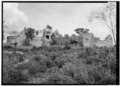
| DescriptionAnnaberg sugar plantation ruins.jpg | Annaberg sugar mill ruins on St. John, United States Virgin Islands. A view from West:Horse mill to left, mill tower, boiling house in center, storage and curing house to right. | ||
| Date | |||
| Source |
Historic American Buildings Survey, Library of Congress.
|
||
| Author | Frederik C. Gjessing | ||
| Other versions |
|

| Object location | 18° 21′ 53″ N, 64° 44′ 18″ W | View this and other nearby images on: OpenStreetMap |
|---|

|
This file comes from the Historic American Buildings Survey (HABS), Historic American Engineering Record (HAER) or Historic American Landscapes Survey (HALS). These are programs of the National Park Service established for the purpose of documenting historic places. Records consist of measured drawings, archival photographs, and written reports.
|
| Public domainPublic domainfalsefalse |
| This image or media file contains material based on a work of a National Park Service employee, created as part of that person's official duties. As a work of the U.S. federal government, such work is in the public domain in the United States. See the NPS website and NPS copyright policy for more information. |
Captions
Items portrayed in this file
depicts
November 1959
18°21'52.999"N, 64°44'17.999"W
image/jpeg
3e68d75da55ff18ba9214134b893cb7cd4d421a7
3,183,541 byte
3,345 pixel
4,699 pixel
File history
Click on a date/time to view the file as it appeared at that time.
| Date/Time | Thumbnail | Dimensions | User | Comment | |
|---|---|---|---|---|---|
| current | 15:30, 2 December 2016 | | 4,699 × 3,345 (3.04 MB) | Kaganer | large from tiff |
| 17:34, 22 July 2008 |  | 979 × 608 (123 KB) | FloNight | {{Information |Description=Annaberg sugar mill ruins on St. John, United States Virgin Islands. A view from West:Horse mill to left, mill tower, boiling house in center, storage and curing house to right. |Source=Library of Congress. {{LOC-image|hhh.vi01 | |
| 17:31, 22 July 2008 |  | 1,024 × 732 (173 KB) | FloNight | {{Information |Description=Annaberg sugar mill ruins on St. John, United States Virgin Islands. A view from West:Horse mill to left, mill tower, boiling house in center, storage and curing house to right. |Source=Library of Congress. {{LOC-image|hhh.vi01 |
File usage
Global file usage
The following other wikis use this file:
- Usage on de.wikipedia.org
- Usage on es.wikipedia.org
Metadata
This file contains additional information, probably added from the digital camera or scanner used to create or digitize it.
If the file has been modified from its original state, some details may not fully reflect the modified file.
| Author | Library of Congress |
|---|---|
| Width | 4,993 px |
| Height | 3,571 px |
| Compression scheme | Uncompressed |
| Pixel composition | Black and white (Black is 0) |
| Orientation | Normal |
| Number of components | 1 |
| Horizontal resolution | 700 dpi |
| Vertical resolution | 700 dpi |
| Data arrangement | chunky format |
| Software used | Adobe Photoshop CS6 (Windows) |
| File change date and time | 18:28, 2 December 2016 |
| Color space | Uncalibrated |
| Date and time of digitizing | 21:09, 2 December 2016 |
| Date metadata was last modified | 21:28, 2 December 2016 |
| Unique ID of original document | xmp.did:F627A53799B8E611B64FFC6F3607B331 |
| IIM version | 44,160 |