File:Bradley_Stoke_Community_School_-_geograph.org.uk_-_139506.jpg
From Wikipedia, the free encyclopedia
No higher resolution available.
Bradley_Stoke_Community_School_-_geograph.org.uk_-_139506.jpg (336 × 354 pixels, file size: 71 KB, MIME type: image/jpeg)
| This is a file from the Wikimedia Commons. Information from its description page there is shown below. Commons is a freely licensed media file repository. You can help. |
Summary
| DescriptionBradley Stoke Community School - geograph.org.uk - 139506.jpg |
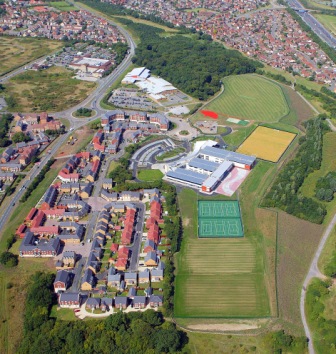
English: Bradley Stoke Community School. This is an aerial view of the new Bradley Stoke Community School. Towards the top of the photo is Savages Wood and in between the two is Bradley Stoke Leisure Centre. You can see Tesco's on the other side of the main road (Bradley Stoke Way). |
| Date | |
| Source | From geograph.org.uk |
| Author | Tony Battista |
| Attribution (required by the license) InfoField | Tony Battista / Bradley Stoke Community School / |
InfoField | Tony Battista / Bradley Stoke Community School |
| Object location | 51° 31′ 41″ N, 2° 32′ 24″ W | View this and other nearby images on: OpenStreetMap |
|---|
Licensing

|
This image was taken from the Geograph project collection. See this photograph's page on the Geograph website for the photographer's contact details. The copyright on this image is owned by Tony Battista and is licensed for reuse under the Creative Commons Attribution-ShareAlike 2.0 license.
|
This file is licensed under the Creative Commons Attribution-Share Alike 2.0 Generic license.
Attribution: Tony Battista
- You are free:
- to share – to copy, distribute and transmit the work
- to remix – to adapt the work
- Under the following conditions:
- attribution – You must give appropriate credit, provide a link to the license, and indicate if changes were made. You may do so in any reasonable manner, but not in any way that suggests the licensor endorses you or your use.
- share alike – If you remix, transform, or build upon the material, you must distribute your contributions under the same or compatible license as the original.
- Remove redundant categories and try to put this image in the most specific category/categories
- Remove this template
- The location categories are based on information from this geonames tool and this OpenStreetMap tool combined with a database. You can also have a look at this tool from mysociety.
- The topic category from Geograph was School (find similar images at Geograph)
English | suomi | français | galego | עברית | magyar | македонски | മലയാളം | português | português do Brasil | Türkçe | +/−
Captions
Add a one-line explanation of what this file represents
Items portrayed in this file
depicts
some value
23 August 2005
51°31'40.8"N, 2°32'24.0"W
0.00025 second
24 millimetre
400
image/jpeg
8c6833341c79de8791201f85fea047dcb0724cd9
72,523 byte
354 pixel
336 pixel
File history
Click on a date/time to view the file as it appeared at that time.
| Date/Time | Thumbnail | Dimensions | User | Comment | |
|---|---|---|---|---|---|
| current | 03:21, 31 January 2010 | | 336 × 354 (71 KB) | GeographBot | == {{int:filedesc}} == {{Information |description={{en|1=Bradley Stoke Community School. This is an aerial view of the new Bradley Stoke Community School. Towards the top of the photo is Savages Wood and in between the two is Bradley Stoke Leisure Centre. |
File usage
The following pages on the English Wikipedia use this file (pages on other projects are not listed):
Global file usage
The following other wikis use this file:
- Usage on www.wikidata.org
Metadata
This file contains additional information, probably added from the digital camera or scanner used to create or digitize it.
If the file has been modified from its original state, some details may not fully reflect the modified file.
| Camera manufacturer | Canon |
|---|---|
| Camera model | Canon EOS-1DS |
| Exposure time | 1/4,000 sec (0.00025) |
| F-number | f/4 |
| ISO speed rating | 400 |
| Date and time of data generation | 13:46, 23 August 2005 |
| Lens focal length | 24 mm |
| Software used | Adobe Photoshop CS Windows |
| File change date and time | 14:46, 24 August 2005 |
| Y and C positioning | Co-sited |
| Exposure Program | Aperture priority |
| Exif version | 2.2 |
| Date and time of digitizing | 13:46, 23 August 2005 |
| Shutter speed | 12 |
| APEX aperture | 4 |
| Exposure bias | 0.66666666666667 |
| Metering mode | Pattern |
| Flash | Flash did not fire |
| Color space | sRGB |
| Focal plane X resolution | 2,886.3636363636 |
| Focal plane Y resolution | 2,885.8057630736 |
| Focal plane resolution unit | inches |
| Custom image processing | Normal process |
| Exposure mode | Auto exposure |
| White balance | Auto white balance |
| Scene capture type | Standard |