File:Chickahominymap.png
From Wikipedia, the free encyclopedia
No higher resolution available.
Chickahominymap.png (292 × 241 pixels, file size: 68 KB, MIME type: image/png)
| This is a file from the Wikimedia Commons. Information from its description page there is shown below. Commons is a freely licensed media file repository. You can help. |
Summary
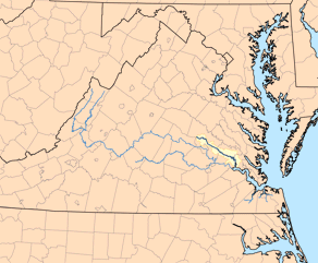
| DescriptionChickahominymap.png | This is a map of the Chickahominy River watershed. I, Karl Musser, created it based on USGS data. |
| Date | 21 December 2006 (original upload date) |
| Source | No machine-readable source provided. Own work assumed (based on copyright claims). |
| Author | No machine-readable author provided. Kmusser assumed (based on copyright claims). |
Licensing
I, the copyright holder of this work, hereby publish it under the following license:
This file is licensed under the Creative Commons Attribution-Share Alike 2.5 Generic license.
- You are free:
- to share – to copy, distribute and transmit the work
- to remix – to adapt the work
- Under the following conditions:
- attribution – You must give appropriate credit, provide a link to the license, and indicate if changes were made. You may do so in any reasonable manner, but not in any way that suggests the licensor endorses you or your use.
- share alike – If you remix, transform, or build upon the material, you must distribute your contributions under the same or compatible license as the original.
Captions
Add a one-line explanation of what this file represents
Items portrayed in this file
depicts
21 December 2006
image/png
fccfff7788b003fb066442132d9cf82c8456c68a
69,512 byte
241 pixel
292 pixel
File history
Click on a date/time to view the file as it appeared at that time.
| Date/Time | Thumbnail | Dimensions | User | Comment | |
|---|---|---|---|---|---|
| current | 05:14, 14 December 2010 | | 292 × 241 (68 KB) | KimChee | cropped unnecessary border |
| 21:36, 10 January 2007 |  | 300 × 248 (26 KB) | Kmusser | changed to just the Chickahominy. | |
| 19:21, 21 December 2006 |  | 300 × 248 (27 KB) | Kmusser | This is a map of the James River system with the Chickahominy River highlighted. I, Karl Musser, created it based on USGS data. {{self|cc-by-sa-2.5}} [[Category:M |
File usage
The following pages on the English Wikipedia use this file (pages on other projects are not listed):
Global file usage
The following other wikis use this file:
- Usage on de.wikipedia.org
- Usage on es.wikipedia.org
- Usage on it.wikipedia.org
- Usage on pl.wikipedia.org
- Usage on www.wikidata.org
Retrieved from "https://en.wikipedia.org/wiki/File:Chickahominymap.png"