File:China-Inner-Mongolia.png
From Wikipedia, the free encyclopedia
China-Inner-Mongolia.png (268 × 218 pixels, file size: 15 KB, MIME type: image/png)
| This is a file from the Wikimedia Commons. Information from its description page there is shown below. Commons is a freely licensed media file repository. You can help. |
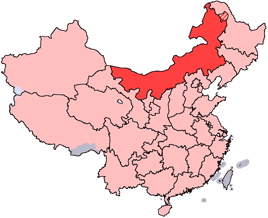
en: Location of Inner Mongolia Autonomous Region in the People's Republic of China. See Locator maps of province-level divisions of the People's Republic of China for more information. The striped area is nominally part of Inner Mongolia, but it is administered by Daxing'anling Prefecture of Heilongjiang Province.
zh: 内蒙古自治區在中華人民共和國的位置。另見Locator maps of province-level divisions of the People's Republic of China。加斜杠的地區由黑龍江省大興安嶺地區所管轄,僅在名義上為内蒙古的一部分。

|
Permission is granted to copy, distribute and/or modify this document under the terms of the GNU Free Documentation License, Version 1.2 or any later version published by the Free Software Foundation; with no Invariant Sections, no Front-Cover Texts, and no Back-Cover Texts. A copy of the license is included in the section entitled GNU Free Documentation License.http://www.gnu.org/copyleft/fdl.htmlGFDLGNU Free Documentation Licensetruetrue |
| This file is licensed under the Creative Commons Attribution-Share Alike 3.0 Unported license. | ||
| ||
| This licensing tag was added to this file as part of the GFDL licensing update.http://creativecommons.org/licenses/by-sa/3.0/CC BY-SA 3.0Creative Commons Attribution-Share Alike 3.0truetrue |
Captions
Items portrayed in this file
depicts
image/png
6e79fbb93b108a1f0ce758c76255405e1959b5ce
15,782 byte
218 pixel
268 pixel
File history
Click on a date/time to view the file as it appeared at that time.
| Date/Time | Thumbnail | Dimensions | User | Comment | |
|---|---|---|---|---|---|
| current | 14:44, 15 July 2005 | | 268 × 218 (15 KB) | Schaengel89~commonswiki | transparent background |
| 21:42, 4 June 2005 |  | 268 × 218 (9 KB) | Ran | '''en''': Location of Inner Mongolia in the People's Republic of China. See Category:Locator maps of province-level divisions of the People's Republic of China for more information. '''zh''': 内蒙古自治區在中華人民共和國的位置。另 |
File usage
More than 100 pages use this file. The following list shows the first 100 pages that use this file only. A full list is available.
- Alxa Left Banner
- Alxa Right Banner
- Aohan Banner
- Ar Horqin Banner
- Arun Banner
- Bailingmiao
- Bairin Right Banner
- Baochang, Taibus Banner
- Bayin-Gobi Formation
- Bordered Yellow Banner, Inner Mongolia
- Buir Lake
- Chifeng Yulong Airport
- Dalad Banner
- Darhan Muminggan United Banner
- Dashuigou Formation
- Dengkou County
- Dolon Nor
- Donghe District
- Dongsheng District
- Duolun County
- East Ujimqin Banner
- Evenk Ethnic Sum
- Fengzhen
- Guyang County
- Haibowan District
- Hainan District
- Hanggai (village)
- Hanggin Banner
- Hanggin Rear Banner
- Harqin Banner
- Hexigten Banner
- Hobor
- Hondlon District
- Honggor Sum, Siziwang Banner
- Honggor Sum, Sonid Left Banner
- Hongort
- Hongshan District, Chifeng
- Horinger County
- Horqin District
- Horqin Left Middle Banner
- Horqin Left Rear Banner
- Horqin Right Front Banner
- Huade County
- Huimin, Hohhot
- Hulunbuir Hailar Airport
- Hure Banner
- Jalaid Banner
- Jarud Banner
- Jiuyuan District
- Jungar Banner
- Kailu County
- Lang Mountains
- Liangcheng County
- Liaobei
- Linxi County, Inner Mongolia
- Naiman Banner
- New Barag Left Banner
- New Barag Right Banner
- Ningcheng County
- Old Barag Banner
- Ongniud Banner
- Oroqen Autonomous Banner
- Otog Front Banner
- Plain Blue Banner, Inner Mongolia
- Plain and Bordered White Banner
- Qahar Right Front Banner
- Qahar Right Middle Banner
- Qahar Right Rear Banner
- Qingshan District, Baotou
- Qingshuihe County
- Saihan, Hohhot
- Shangdu County
- Shiguai District
- Solun, Horqin Right Front Banner
- Sonid Left Banner
- Sonid Right Banner
- Taibus Banner
- Tengger Desert
- Togtoh County
- Tongliao Airport
- Tsondol
- Tumed Left Banner
- Tumed Right Banner
- Tuquan County
- Urad Front Banner
- Urad Middle Banner
- Urad Rear Banner
- Uxin Banner
- West Ujimqin Banner
- Wuda District
- Wuyuan County, Inner Mongolia
- Xar Moron River
- Xilinhot Airport
- Xincheng, Hohhot
- Xinghe County
- Xuejiawan, Jungar Banner
- Yin Mountains
- Yuanbaoshan District
- Yuquan, Hohhot
- Zhuozi County
View more links to this file.
Global file usage
The following other wikis use this file:
- Usage on da.wikipedia.org
- Usage on de.wikipedia.org
- Usage on fo.wikipedia.org
- Usage on fr.wikipedia.org
- Usage on jv.wikipedia.org
- Usage on ko.wikipedia.org
- Usage on nn.wikipedia.org
- Usage on su.wikipedia.org
- Usage on sv.wikinews.org
- Usage on www.wikidata.org
- Usage on wuu.wikipedia.org