File:DeSoto_Map_HRoe_2008.jpg
From Wikipedia, the free encyclopedia
Size of this preview: 759 × 600 pixels. Other resolutions: 304 × 240 pixels | 608 × 480 pixels | 810 × 640 pixels.
Original file (810 × 640 pixels, file size: 530 KB, MIME type: image/jpeg)
| This is a file from the Wikimedia Commons. Information from its description page there is shown below. Commons is a freely licensed media file repository. You can help. |
Summary
| DescriptionDeSoto Map HRoe 2008.jpg |
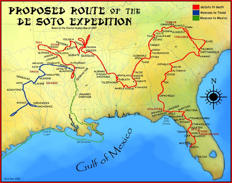
English: A map showing the proposed route of the de Soto Expedition, based on the 1997 Charles Hudson map. |
| Date |
19 September 2008 (original upload date) |
| Source | Created by Herb Roe 2008. |
| Author | Heironymous Rowe (talk) |
Licensing
This file is licensed under the Creative Commons Attribution-Share Alike 3.0 Unported license.
Attribution: Herb Roe
- You are free:
- to share – to copy, distribute and transmit the work
- to remix – to adapt the work
- Under the following conditions:
- attribution – You must give appropriate credit, provide a link to the license, and indicate if changes were made. You may do so in any reasonable manner, but not in any way that suggests the licensor endorses you or your use.
- share alike – If you remix, transform, or build upon the material, you must distribute your contributions under the same or compatible license as the original.
Original upload log
Transferred from en.wikipedia to Commons by Spyder_Monkey using CommonsHelper.
The original description page was here. All following user names refer to en.wikipedia.
- 2008-09-19 22:27 Heironymous Rowe 810×640× (542344 bytes) {{Information |Description=A map showing the proposed route of the de Soto Expedition, based on the 1997 [[Charles M. Hudson(author)|Charles Hudson]] map. |Source=I created this work entirely by myself. |Date=2008 |Author=~~~ |other_versions= }}
Captions
Add a one-line explanation of what this file represents
Items portrayed in this file
depicts
19 September 2008
image/jpeg
File history
Click on a date/time to view the file as it appeared at that time.
| Date/Time | Thumbnail | Dimensions | User | Comment | |
|---|---|---|---|---|---|
| current | 05:53, 1 March 2009 | | 810 × 640 (530 KB) | File Upload Bot (Magnus Manske) | {{BotMoveToCommons|en.wikipedia|year={{subst:CURRENTYEAR}}|month={{subst:CURRENTMONTHNAME}}|day={{subst:CURRENTDAY}}}} {{Information |Description={{en|A map showing the proposed route of the de Soto Expedition, based on the 1997 |
File usage
The following pages on the English Wikipedia use this file (pages on other projects are not listed):
- Charles M. Hudson
- Conquistador
- Demographics of Georgia (U.S. state)
- Hernando de Soto
- History of Georgia (U.S. state)
- History of Memphis, Tennessee
- History of Mississippi
- History of North Carolina
- History of the Southern United States
- List of conflicts in North America
- List of sites and peoples visited by the Hernando de Soto Expedition
- Luis de Moscoso Alvarado
- Mississippian culture
- Mississippian shatter zone
- Pensacola culture
- Plaquemine culture
- Taensa
- Tunica people
- Talk:History of Randolph, Tennessee
- User:Heironymous Rowe/Useful books and their citations
- Portal:Mississippi
- Portal:North Carolina
Global file usage
The following other wikis use this file:
- Usage on af.wikipedia.org
- Usage on ar.wikipedia.org
- Usage on ast.wikipedia.org
- Usage on bg.wikipedia.org
- Usage on bn.wikipedia.org
- Usage on br.wikipedia.org
- Usage on ca.wikipedia.org
- Usage on ce.wikipedia.org
- Usage on cs.wikipedia.org
- Usage on de.wikipedia.org
- Usage on es.wikipedia.org
- Usage on et.wikipedia.org
- Usage on fa.wikipedia.org
- Usage on ga.wikipedia.org
- Usage on he.wikipedia.org
- Usage on id.wikipedia.org
- Usage on it.wikipedia.org
- Usage on ja.wikipedia.org
- Usage on kk.wikipedia.org
- Usage on ko.wikipedia.org
- Usage on la.wikipedia.org
- Usage on nl.wikipedia.org
- Usage on pt.wikipedia.org
- Usage on ru.wikipedia.org
- Usage on sh.wikipedia.org
- Usage on sr.wikipedia.org
- Usage on sv.wikipedia.org
View more global usage of this file.
Metadata
This file contains additional information, probably added from the digital camera or scanner used to create or digitize it.
If the file has been modified from its original state, some details may not fully reflect the modified file.
| Orientation | Normal |
|---|---|
| Horizontal resolution | 72 dpi |
| Vertical resolution | 72 dpi |
| Software used | Adobe Photoshop 7.0 |
| File change date and time | 17:21, 19 September 2008 |
| Color space | sRGB |
Retrieved from "https://en.wikipedia.org/wiki/File:DeSoto_Map_HRoe_2008.jpg"