File:Detail_of_CA-99_viewed_from_I-5_northbound_near_the_Tejon_Pass_in_Lebec,_California.JPG
From Wikipedia, the free encyclopedia
Original file (3,396 × 3,396 pixels, file size: 4.53 MB, MIME type: image/jpeg)
| This is a file from the Wikimedia Commons. Information from its description page there is shown below. Commons is a freely licensed media file repository. You can help. |
Summary
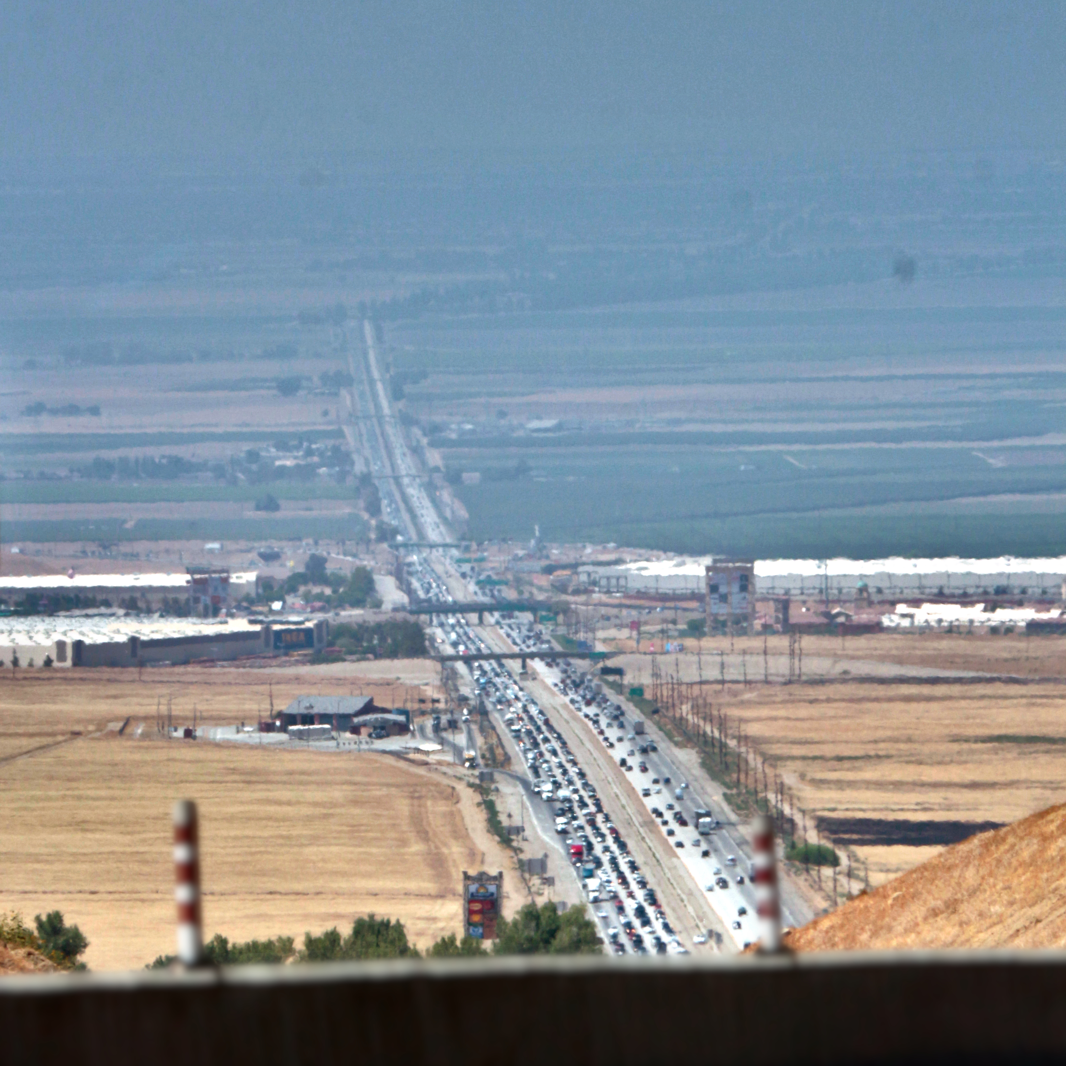
| DescriptionDetail of CA-99 viewed from I-5 northbound near the Tejon Pass in Lebec, California.JPG |
Much as the previous one (File:CA-99 viewed from I-5 northbound near the Tejon Pass in Lebec, California.JPG), but this one is specifically of CA-99 and the Wheeler Ridge Interchange.
Coordinates for the overpasses, since those are easily seen: First from bottom: Unnamed canal road, 34.972370824515046, -118.94085333371474 Second: S Wheeler Ridge Rd, 34.98639027394168, -118.94529263983678 Third: West Side Fwy flyover (I-5, Wheeler Ridge Interchange), 35.01852421802179, -118.95545061045831 Fourth: SR-166 flyover, 35.0578130108648, -118.96782957843227 Fifth: David Rd, 35.094459740022806, -118.97956374493931 Sixth: Sandrini Rd, 35.12195468152039, -118.9881216288916 Seventh: Herring Rd, 35.15008686935864, -118.99708762404487 Eighth: SR-99B flyover, 35.172911885332276, -119.00434478622316 |
||||
| Source | A freakin' camera. | ||||
| Author | JPxG |
Licensing

|
Permission is granted to copy, distribute and/or modify this document under the terms of the GNU Free Documentation License, Version 1.2 or any later version published by the Free Software Foundation; with no Invariant Sections, no Front-Cover Texts, and no Back-Cover Texts. A copy of the license is included in the section entitled GNU Free Documentation License.http://www.gnu.org/copyleft/fdl.htmlGFDLGNU Free Documentation Licensetruetrue |
- You are free:
- to share – to copy, distribute and transmit the work
- to remix – to adapt the work
- Under the following conditions:
- attribution – You must give appropriate credit, provide a link to the license, and indicate if changes were made. You may do so in any reasonable manner, but not in any way that suggests the licensor endorses you or your use.
- share alike – If you remix, transform, or build upon the material, you must distribute your contributions under the same or compatible license as the original.
Captions
Items portrayed in this file
depicts
34°54'46.63976234713"N, 118°55'23.80234536825"W
0.002 second
11
250 millimetre
200
image/jpeg
File history
Click on a date/time to view the file as it appeared at that time.
| Date/Time | Thumbnail | Dimensions | User | Comment | |
|---|---|---|---|---|---|
| current | 04:35, 8 July 2021 | | 3,396 × 3,396 (4.53 MB) | JPxG | Defocus those stupid freaking poles in the foreground |
| 04:34, 8 July 2021 |  | 3,396 × 3,396 (4.84 MB) | JPxG | Crop to square. | |
| 04:19, 8 July 2021 |  | 3,396 × 5,184 (6.43 MB) | JPxG | GIMP automatic white balance layer at 50% opacity again | |
| 04:18, 8 July 2021 |  | 3,396 × 5,184 (5.65 MB) | JPxG | Brightness -100 with radius 300, and extremely minor crop off the left to eliminate the infuriating edge of a sign. | |
| 03:57, 8 July 2021 |  | 3,456 × 5,184 (5.13 MB) | JPxG | Highlights -50, with color correction at 50, to make the highway more visible. | |
| 03:54, 8 July 2021 |  | 3,456 × 5,184 (4.96 MB) | JPxG | GIMP automatic white balance layer at 50% opacity | |
| 03:52, 8 July 2021 |  | 3,456 × 5,184 (3.19 MB) | JPxG | {{Information |Description=Much as the previous one (CA-99 viewed from I-5 northbound near the Tejon Pass in Lebec, California.JPG), but this one is specifically of CA-99 and the Wheeler Ridge Interchange. {{location|34.91295548954087|-118.92327842926896|N}} |Source=A freakin' camera. |Date= |Author=JPxG |Permission= |other_versions= }} |
File usage
Metadata
This file contains additional information, probably added from the digital camera or scanner used to create or digitize it.
If the file has been modified from its original state, some details may not fully reflect the modified file.
| Image title | binary comment |
|---|---|
| Camera manufacturer | Canon |
| Camera model | Canon EOS REBEL T4i |
| Author | JPXG |
| Copyright holder | CC BY-SA 4.0 |
| Exposure time | 1/500 sec (0.002) |
| F-number | f/11 |
| ISO speed rating | 200 |
| Date and time of data generation | 14:36, 5 July 2021 |
| Lens focal length | 250 mm |
| User comments | binary comment |
| JPEG file comment | binary comment |
| Orientation | Normal |
| Horizontal resolution | 72 dpi |
| Vertical resolution | 72 dpi |
| Software used | GIMP 2.10.22 |
| File change date and time | 21:32, 7 July 2021 |
| White point chromaticity |
|
| Chromaticities of primarities |
|
| Color space transformation matrix coefficients |
|
| Y and C positioning | Co-sited |
| Exposure Program | Manual |
| Exif version | 2.3 |
| Date and time of digitizing | 14:36, 5 July 2021 |
| Meaning of each component |
|
| Shutter speed | 9 |
| APEX aperture | 7 |
| Exposure bias | 0 |
| Metering mode | Partial |
| Flash | Flash did not fire, compulsory flash suppression |
| DateTime subseconds | 08 |
| DateTimeOriginal subseconds | 08 |
| DateTimeDigitized subseconds | 08 |
| Supported Flashpix version | 1 |
| Color space | sRGB |
| Focal plane X resolution | 5,798.6577181208 |
| Focal plane Y resolution | 5,788.9447236181 |
| Focal plane resolution unit | inches |
| Custom image processing | Normal process |
| Exposure mode | Manual exposure |
| White balance | Manual white balance |
| Scene capture type | Standard |
| GPS tag version | 0.0.3.2 |
| Unique ID of original document | xmp.did:bf836c46-e4cd-4857-b107-6a945e577487 |
| Rating (out of 5) | 0 |