File:Finland-Norway_border_map.png
From Wikipedia, the free encyclopedia
No higher resolution available.
Finland-Norway_border_map.png (514 × 290 pixels, file size: 93 KB, MIME type: image/png)
| This is a file from the Wikimedia Commons. Information from its description page there is shown below. Commons is a freely licensed media file repository. You can help. |
Summary
| DescriptionFinland-Norway border map.png |
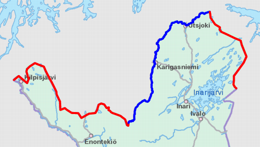
English: Schematic map of the Finland–Norway border. Land border highlighted in red and river border in blue.
Map cropped from the 1:4000000 background map provided by the NLS of Finland. Highlighted border is based on free numeric data provided by the NLS. Suomi: Karttakuva Suomen ja Norjan rajasta. Maaraja korostettu punaisella ja jokiraja sinisellä.
Karttapohja on otettu Maanmittauslaitoksen 1:4000000 taustakartasta, johon on lisätty värikorostus Maanmittauslaitoksen numeerisen aineiston avulla. |
| Date | |
| Source | https://tiedostopalvelu.maanmittauslaitos.fi/tp/kartta?lang=en |
| Author | National Land Survey of Finland; color highlights added by Jmk |
Licensing

|
This file is licensed under the National Land Survey open data licence, version 1.0 (1 May 2012) published by the National Land Survey of Finland.
You are free to:
You must, through reasonable means:
The terms of this licence do not allow you to state in conjunction with the use of dataset(s) that the NLS supports or recommends such use. |
 |
| Attribution: contains map data from the National Land Survey of Finland Topographic Database 09/2012
Deutsch | English | suomi | svenska | +/− National Land Survey open data licence - version 1.0NLS open data 1.0http://www.maanmittauslaitos.fi/en/NLS_open_data_licence_version1_20120501true |
Captions
Add a one-line explanation of what this file represents
Items portrayed in this file
depicts
9 November 2012
File history
Click on a date/time to view the file as it appeared at that time.
| Date/Time | Thumbnail | Dimensions | User | Comment | |
|---|---|---|---|---|---|
| current | 10:12, 9 November 2012 | | 514 × 290 (93 KB) | Jmk | User created page with UploadWizard |
File usage
The following pages on the English Wikipedia use this file (pages on other projects are not listed):
Global file usage
The following other wikis use this file:
- Usage on ckb.wikipedia.org
- Usage on cs.wikipedia.org
- Usage on de.wikipedia.org
- Usage on es.wikipedia.org
- Usage on fi.wikipedia.org
- Usage on fi.wiktionary.org
- Usage on hr.wikipedia.org
- Usage on it.wikipedia.org
- Usage on sv.wikipedia.org
- Usage on uk.wikipedia.org
Metadata
This file contains additional information, probably added from the digital camera or scanner used to create or digitize it.
If the file has been modified from its original state, some details may not fully reflect the modified file.
| Horizontal resolution | 37.8 dpc |
|---|---|
| Vertical resolution | 37.8 dpc |
Retrieved from "https://en.wikipedia.org/wiki/File:Finland-Norway_border_map.png"