File:Geologic_Map_of_Georgia.png
From Wikipedia, the free encyclopedia
Original file (2,640 × 3,000 pixels, file size: 1.31 MB, MIME type: image/png)
| This is a file from the Wikimedia Commons. Information from its description page there is shown below. Commons is a freely licensed media file repository. You can help. |
| DescriptionGeologic Map of Georgia.png | |
| Source |
This file is lacking source information.
Please edit this file's description and provide a source. |
| Author |
This file is lacking author information.
|
Licensing
| Public domainPublic domainfalsefalse |
This image is in the public domain in the United States because it only contains materials that originally came from the United States Geological Survey, an agency of the United States Department of the Interior. For more information, see the official USGS copyright policy.
Bahasa Indonesia ∙ català ∙ čeština ∙ Deutsch ∙ eesti ∙ English ∙ español ∙ français ∙ galego ∙ italiano ∙ Nederlands ∙ português ∙ polski ∙ sicilianu ∙ suomi ∙ Tiếng Việt ∙ Türkçe ∙ български ∙ македонски ∙ русский ∙ മലയാളം ∙ 한국어 ∙ 日本語 ∙ 中文 ∙ 中文(简体) ∙ 中文(繁體) ∙ العربية ∙ فارسی ∙ +/− |
Original upload log
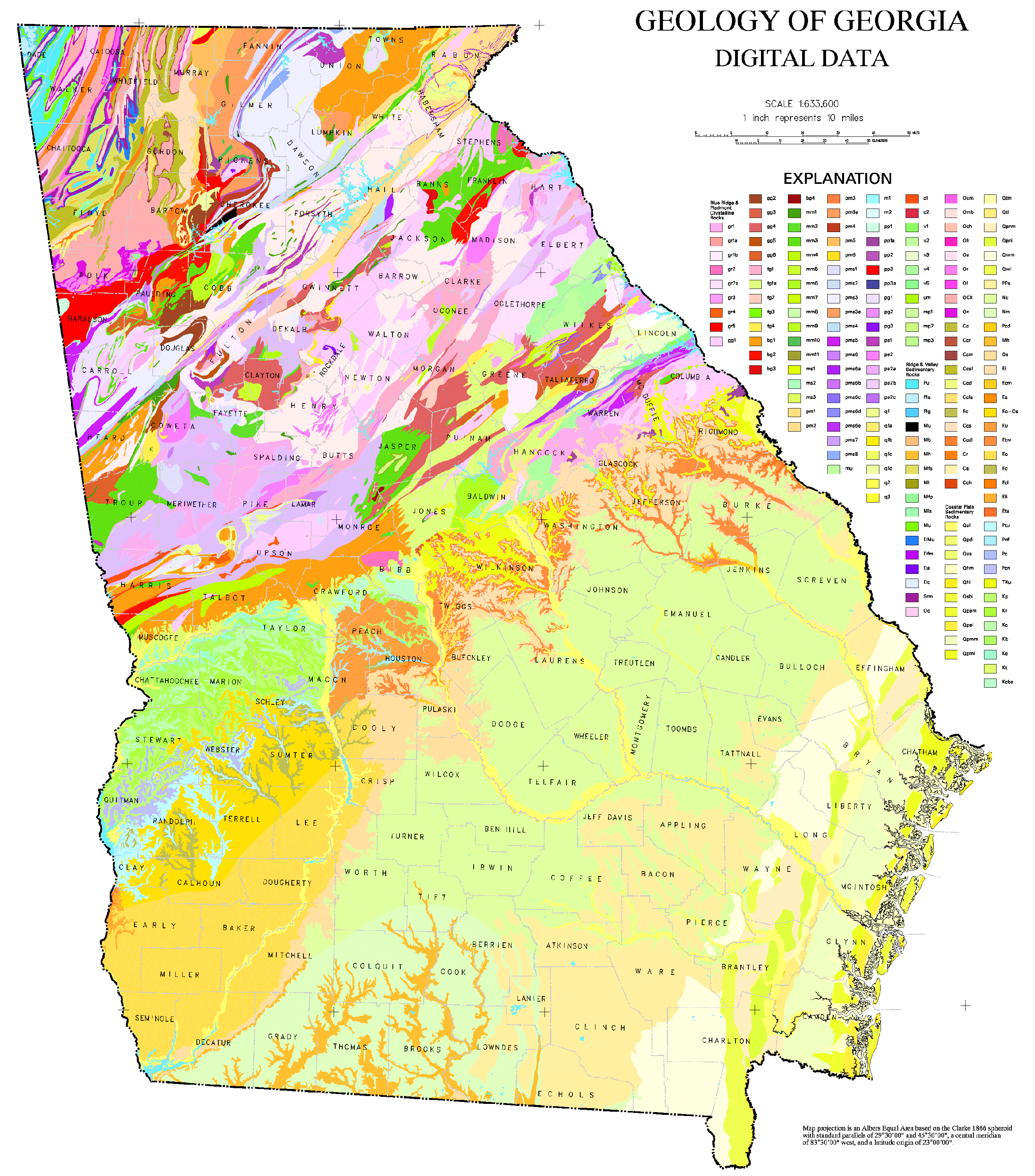
- 2006-10-24 21:50 Tlmclain 3086×3450× (1836224 bytes) The map compilation was published by the Georgia Geologic Survey in 1976 as the Geologic Map of [[Georgia (U.S. State)|Georgia]]. Source: [http://csat.er.usgs.gov/statewide/layers/geology.html USGS] {{PD-USGov-Interior-USGS}} [[Category:Georgia (U.S. sta
Captions
Items portrayed in this file
depicts
File history
Click on a date/time to view the file as it appeared at that time.
| Date/Time | Thumbnail | Dimensions | User | Comment | |
|---|---|---|---|---|---|
| current | 17:00, 27 March 2021 | | 2,640 × 3,000 (1.31 MB) | User-duck | Cropped borders using CropTool with lossless mode. |
| 20:50, 9 April 2009 |  | 3,086 × 3,450 (1.75 MB) | File Upload Bot (Magnus Manske) | {{BotMoveToCommons|en.wikipedia|year={{subst:CURRENTYEAR}}|month={{subst:CURRENTMONTHNAME}}|day={{subst:CURRENTDAY}}}} {{Information |Description={{en|The map compilation was published by the Georgia Geologic Survey in 1976 as the Geologic Map of [[:en:G |
File usage
- Chorochromatic map
- Field (geography)
- Geologic mapping of Georgia (U.S. state)
- Geology of Georgia (U.S. state)
- Qualitative geography
- Thematic map
- User:Abyssal/Portal:Cambrian/Science, culture, and economics articles/6
- User:Abyssal/Portal:Carboniferous/Science, culture, and economics articles/7
- User:Abyssal/Portal:Cenozoic/Science, culture, and economics articles/9
- User:Abyssal/Portal:Devonian/Science, culture, and economics articles/4
- User:Abyssal/Portal:Neogene/Science, culture, and economics articles/9
- User:Abyssal/Portal:Ordovician/Science, culture, and economics articles/4
- User:Abyssal/Portal:Paleogene/Science, culture, and economics articles/9
- User:Abyssal/Portal:Quaternary/Science, culture, and economics articles
- User:Abyssal/Portal:Quaternary/Science, culture, and economics articles/9
- User:Abyssal/Portal:Silurian/Science, culture, and economics articles/4
- User:Abyssal/Portal:Triassic/Science, culture, and economics articles/7
- User:Tlmclain
Global file usage
The following other wikis use this file:
- Usage on ko.wikipedia.org
- Usage on ru.wikipedia.org
- Usage on sk.wikipedia.org
- Usage on uk.wikipedia.org
- Usage on www.wikidata.org
- Usage on zh.wikipedia.org
Metadata
This file contains additional information, probably added from the digital camera or scanner used to create or digitize it.
If the file has been modified from its original state, some details may not fully reflect the modified file.
| File change date and time | 16:58, 27 March 2021 |
|---|---|
| Software used |