File:Gy-map.png
From Wikipedia, the free encyclopedia
Size of this preview: 279 × 599 pixels. Other resolutions: 112 × 240 pixels | 329 × 706 pixels.
Original file (329 × 706 pixels, file size: 10 KB, MIME type: image/png)
| This is a file from the Wikimedia Commons. Information from its description page there is shown below. Commons is a freely licensed media file repository. You can help. |
Summary
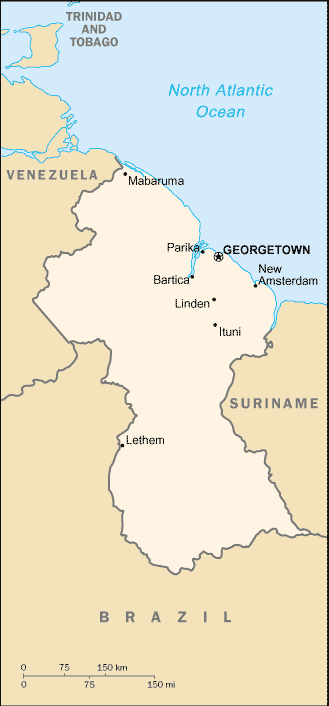
| DescriptionGy-map.png |
English: Map of Guyana from the 2002 CIA Factbook. |
| Date | |
| Source | CIA Factbook |
| Author | Central Intelligence Agency |
Licensing
| Public domainPublic domainfalsefalse |
This image is in the public domain because it contains materials that originally came from the United States Central Intelligence Agency's World Factbook.
Bahasa Indonesia ∙ čeština ∙ Deutsch ∙ eesti ∙ English ∙ español ∙ Esperanto ∙ français ∙ galego ∙ hrvatski ∙ italiano ∙ Nederlands ∙ norsk nynorsk ∙ polski ∙ português ∙ sicilianu ∙ slovenščina ∙ suomi ∙ Türkçe ∙ Zazaki ∙ беларуская (тарашкевіца) ∙ македонски ∙ русский ∙ српски / srpski ∙ українська ∙ ქართული ∙ বাংলা ∙ தமிழ் ∙ മലയാളം ∙ 한국어 ∙ 日本語 ∙ 中文 ∙ 中文(简体) ∙ 中文(繁體) ∙ العربية ∙ +/− |
 |
Original upload log
The original description page was here. All following user names refer to en.wikipedia.
- 2004-04-10 05:11 Bkell 329×706× (9979 bytes) compressed version
- 2003-04-13 11:19 Scipius 329×706× (10779 bytes) Map of Guyana from the 2002 CIA Factbook
Captions
Add a one-line explanation of what this file represents
Items portrayed in this file
depicts
2002
File history
Click on a date/time to view the file as it appeared at that time.
| Date/Time | Thumbnail | Dimensions | User | Comment | |
|---|---|---|---|---|---|
| current | 00:06, 2 November 2011 | | 329 × 706 (10 KB) | OgreBot | (BOT): Reverting to most recent version before archival |
| 00:06, 2 November 2011 |  | 329 × 706 (11 KB) | OgreBot | (BOT): Uploading old version of file from en.wikipedia; originally uploaded on 2003-04-13 11:19:08 by Scipius | |
| 00:03, 2 November 2011 |  | 329 × 706 (10 KB) | File Upload Bot (Magnus Manske) | {{BotMoveToCommons|en.wikipedia|year={{subst:CURRENTYEAR}}|month={{subst:CURRENTMONTHNAME}}|day={{subst:CURRENTDAY}}}} {{Information |Description={{en|Map of Guyana from the 2002 CIA Factbook}} |Source=Transferred from [http://en.wikipedia.org en.wikiped |
File usage
The following pages on the English Wikipedia use this file (pages on other projects are not listed):
Global file usage
The following other wikis use this file:
- Usage on eo.wikipedia.org
- Usage on fi.wikipedia.org
- Usage on ms.wikipedia.org
- Usage on ro.wikipedia.org
- Usage on ru.wikipedia.org
- Usage on sw.wikipedia.org
- Usage on xmf.wikipedia.org
- Usage on zh.wikipedia.org
Retrieved from "https://en.wikipedia.org/wiki/File:Gy-map.png"