File:Heiliges_Römisches_Reich_1000.PNG
From Wikipedia, the free encyclopedia
Original file (6,170 × 4,941 pixels, file size: 50.04 MB, MIME type: image/png)
| This is a file from the Wikimedia Commons. Information from its description page there is shown below. Commons is a freely licensed media file repository. You can help. |
Summary
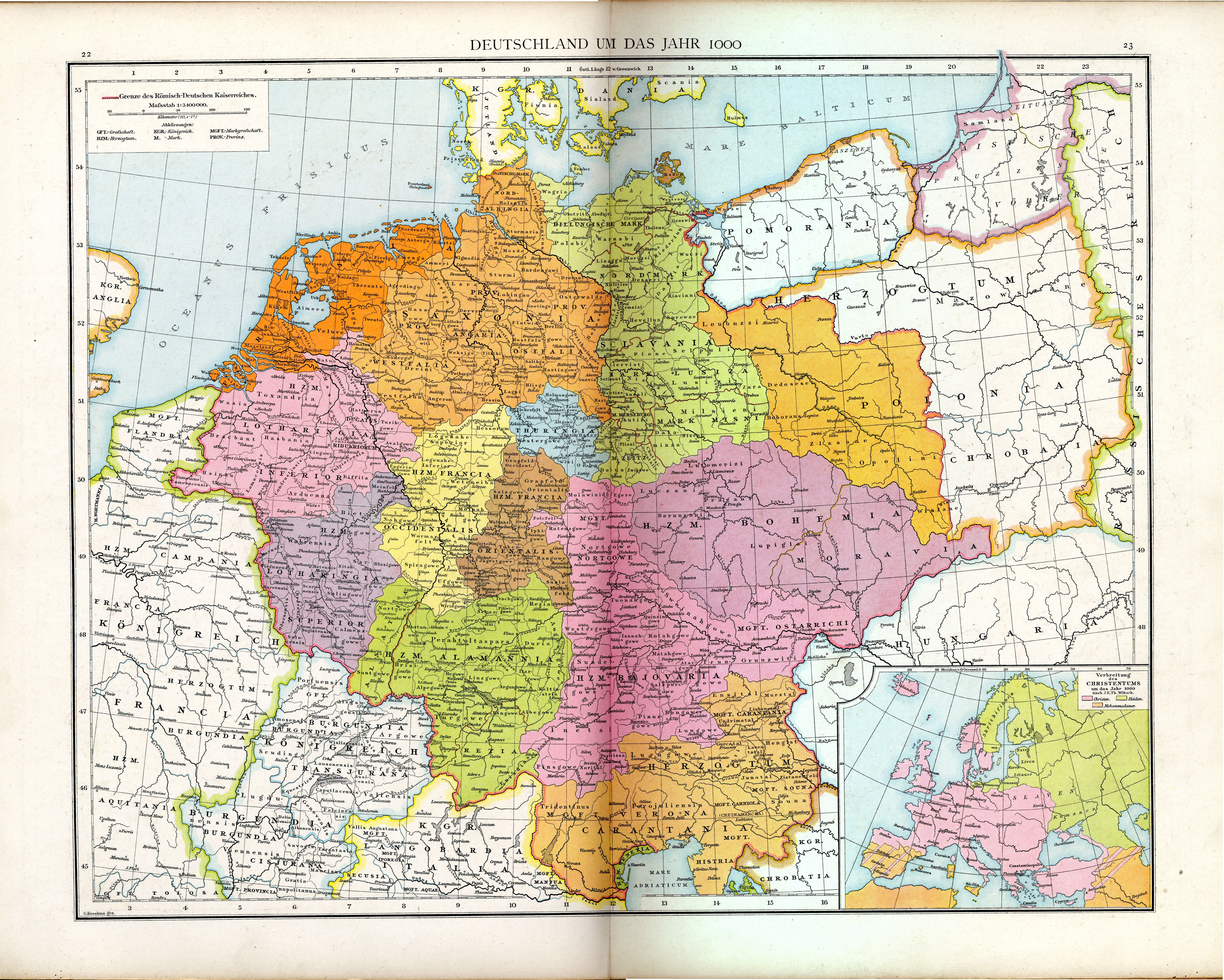
| DescriptionHeiliges Römisches Reich 1000.PNG |
Deutsch: Heiliges Römisches Reich um 1000.
English: Holy Roman Empire around 1000. |
| Date | |
| Source | Gustav Droysen, Allgemeiner historischer Handatlas, Bielefeld/Leipzig 1886, Karte 25. |
| Author | Gustav Droysen |
| Other versions |
|

.jpg)
Licensing
| Public domainPublic domainfalsefalse |
|
This work is in the public domain in its country of origin and other countries and areas where the copyright term is the author's life plus 70 years or fewer.
| |
| This file has been identified as being free of known restrictions under copyright law, including all related and neighboring rights. | |
https://creativecommons.org/publicdomain/mark/1.0/PDMCreative Commons Public Domain Mark 1.0falsefalse
Captions
Items portrayed in this file
depicts
1886
image/png
File history
Click on a date/time to view the file as it appeared at that time.
| Date/Time | Thumbnail | Dimensions | User | Comment | |
|---|---|---|---|---|---|
| current | 09:44, 5 June 2023 | | 6,170 × 4,941 (50.04 MB) | Phreneticc | Reduced file weight with FileOptimizer in lossless compression mode. |
| 13:10, 1 May 2015 |  | 6,170 × 4,941 (67.61 MB) | Pustekuchen2014 | höher auflösendes Bild von http://www.maproom.org/00/08/present.php?m=0022 | |
| 18:23, 26 July 2007 |  | 2,756 × 2,219 (2.46 MB) | Alma | {{Information |Description=Heiliges Römisches Reich um 1000 |Source=Allgemeiner historischer Handatlas |Date=1886 |Author=Gustav Droysen |Permission= |other_versions= }} {{pd-old}} |
File usage
Global file usage
The following other wikis use this file:
- Usage on ar.wikipedia.org
- Usage on bg.wikipedia.org
- Usage on ca.wikipedia.org
- Usage on de.wikipedia.org
- Gau
- Landkreis Kitzingen
- Bliesgau
- Grabfeld
- Eifelgau
- Bidgau
- Ardennengau
- Wirmighausen
- Liste mittelalterlicher Gaue
- Speyergau
- Maasgau
- Jülichgau
- Rurgau
- Tilithigau
- Diskussion:Stedingen
- Dobnagau
- Allgemeiner Historischer Handatlas
- Albgau (Südschwarzwald)
- Isengau (historisch)
- Pflege Coburg
- Datei:Alamannia HRR 1000AD.JPG
- Datei:Sclavania HRR 1000AD.JPG
- Diskussion:Leinegau
- Diskussion:Maulachgau
- Benutzer:Methodios/Weiße Kroaten
- Benutzer:Methodios/Sorbenprojekt
- Benutzer:Methodios/Geschichte von Nisani
- Benutzer:Methodios/Weiße Serben
- Ipfgau
- Murrgau
- Usage on de.wikibooks.org
- Usage on de.wikisource.org
- Usage on fa.wikipedia.org
- Usage on fr.wikipedia.org
- Usage on gl.wikipedia.org
- Usage on hu.wikipedia.org
- Usage on it.wikipedia.org
- Usage on ms.wikipedia.org
View more global usage of this file.