File:Hurleston_Junction.jpg
From Wikipedia, the free encyclopedia
No higher resolution available.
Hurleston_Junction.jpg (640 × 444 pixels, file size: 134 KB, MIME type: image/jpeg)
| This is a file from the Wikimedia Commons. Information from its description page there is shown below. Commons is a freely licensed media file repository. You can help. |
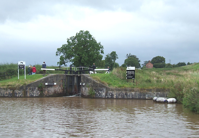
| DescriptionHurleston Junction.jpg | Hurleston Junction. The Llangollen Canal begins here with a flight of four locks raising the water level more than 34 feet (10.4 metres). |
| Date | |
| Source | From geograph.co.uk |
| Author | Roger Kidd |
| Permission (Reusing this file) |
Creative Commons Attribution Share-alike license 2.0 |
| Camera location | 53° 05′ 37.23″ N, 2° 33′ 37.39″ W | View this and other nearby images on: OpenStreetMap |
|---|

|
This image was taken from the Geograph project collection. See this photograph's page on the Geograph website for the photographer's contact details. The copyright on this image is owned by Roger Kidd and is licensed for reuse under the Creative Commons Attribution-ShareAlike 2.0 license.
|
This file is licensed under the Creative Commons Attribution-Share Alike 2.0 Generic license.
Attribution: Roger Kidd
- You are free:
- to share – to copy, distribute and transmit the work
- to remix – to adapt the work
- Under the following conditions:
- attribution – You must give appropriate credit, provide a link to the license, and indicate if changes were made. You may do so in any reasonable manner, but not in any way that suggests the licensor endorses you or your use.
- share alike – If you remix, transform, or build upon the material, you must distribute your contributions under the same or compatible license as the original.
Captions
Add a one-line explanation of what this file represents
Items portrayed in this file
depicts
some value
7 October 2007
53°5'37.234"N, 2°33'37.393"W
image/jpeg
File history
Click on a date/time to view the file as it appeared at that time.
| Date/Time | Thumbnail | Dimensions | User | Comment | |
|---|---|---|---|---|---|
| current | 11:25, 3 August 2008 | | 640 × 444 (134 KB) | Natl1 | {{Information |Description=Hurleston Junction. The Llangollen Canal begins here with a flight of four locks raising the water level more than 34 feet (10.4 metres). |Source=From [http://www.geograph.org.uk/photo/578156 geograph.co.uk] |Date=2007-10-07T19: |
File usage
The following pages on the English Wikipedia use this file (pages on other projects are not listed):
Global file usage
The following other wikis use this file:
- Usage on www.wikidata.org
Retrieved from "https://en.wikipedia.org/wiki/File:Hurleston_Junction.jpg"