File:Juist2.jpg
From Wikipedia, the free encyclopedia
Size of this preview: 800 × 280 pixels. Other resolutions: 320 × 112 pixels | 640 × 224 pixels | 1,405 × 492 pixels.
Original file (1,405 × 492 pixels, file size: 356 KB, MIME type: image/jpeg)
| This is a file from the Wikimedia Commons. Information from its description page there is shown below. Commons is a freely licensed media file repository. You can help. |
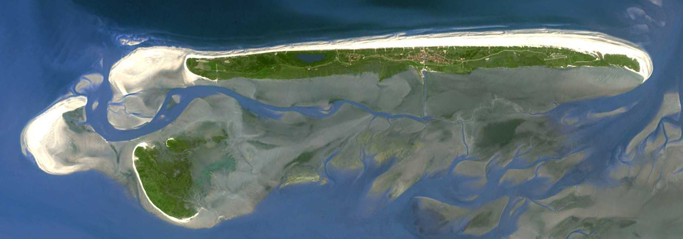
| DescriptionJuist2.jpg |
Deutsch: Insel Juist. Aufnahme von Landsat 7 (NASA) aus ca. 700 Kilometern Höhe. |
||||||
| Date |
before 2005 date QS:P,+2005-00-00T00:00:00Z/7,P1326,+2005-00-00T00:00:00Z/9 |
||||||
| Source |
English: Transferred from de.wikipedia.org [1]: 13:53, 13. Jun 2005 . . Hoipoi . . 1405 x 492 (364780 Byte) – taken from NASA Landsat project (cf. Frisian Islands gallery at npoc.nl and borkum.jpg, so possibly it's a Terra/ASTER image) |
||||||
| Author | NASA | ||||||
| Permission (Reusing this file) |
|

![[1]](/de/Datei:Juist2.jpg)
| Annotations InfoField | This image is annotated: View the annotations at Commons |
251
264
255
211
1405
492
Memmert
33
174
200
221
1405
492
Kachelotplate
251
63
1120
155
1405
492
Juist
File history
Click on a date/time to view the file as it appeared at that time.
| Date/Time | Thumbnail | Dimensions | User | Comment | |
|---|---|---|---|---|---|
| current | 05:11, 9 March 2006 | 1,405 × 492 (356 KB) | Überraschungsbilder | *Insel Juist *Aufnahme von Landsat 7 (NASA) aus ca. 700 Kilometern Höhe. *Quelle: [http://landsat.usgs.gov/ NASA Landsat project] *first upload on de.wikipedia [http://de.wikipedia.org/wiki/Bild:Juist2.jpg] ''13:53, 13. Jun 2005 . . [[:de:Benutzer:Hoipo |
File usage
The following pages on the English Wikipedia use this file (pages on other projects are not listed):
Global file usage
The following other wikis use this file:
- Usage on ar.wikipedia.org
- Usage on cs.wikipedia.org
- Usage on da.wikipedia.org
- Usage on de.wikipedia.org
- Ostfriesische Inseln
- Norderney
- Borkum
- Kachelotplate
- Wangerooge
- Spiekeroog
- Baltrum
- Langeoog
- Memmert
- Minsener Oog
- Mellum
- Lütje Hörn
- Bant (Insel)
- Vorlage:Navigationsleiste Ostfriesische Inseln
- Juist
- Liste der Städte und Gemeinden in Ostfriesland
- Liste der Gemeinden im Landkreis Aurich
- Brauerplate
- Wikipedia:Kartenwerkstatt/Archiv/2011-07
- Usage on eo.wikipedia.org
- Usage on es.wikipedia.org
- Usage on fr.wikipedia.org
- Usage on fy.wikipedia.org
- Usage on it.wikipedia.org
- Usage on ka.wikipedia.org
- Usage on mk.wikipedia.org
- Usage on nds.wikipedia.org
- Usage on nl.wikipedia.org
- Usage on nn.wikipedia.org
- Usage on stq.wikipedia.org
- Usage on sv.wikipedia.org
- Usage on uk.wikipedia.org
- Usage on vi.wikipedia.org
- Usage on xmf.wikipedia.org
Metadata
This file contains additional information, probably added from the digital camera or scanner used to create or digitize it.
If the file has been modified from its original state, some details may not fully reflect the modified file.
| Orientation | Normal |
|---|---|
| Horizontal resolution | 180 dpi |
| Vertical resolution | 180 dpi |
| Software used | Adobe Photoshop 7.0 |
| File change date and time | 14:52, 13 June 2005 |
| Color space | Uncalibrated |
Retrieved from "https://en.wikipedia.org/wiki/File:Juist2.jpg"