File:Karte_Ennetbirgische_Vogteien.png
From Wikipedia, the free encyclopedia
Size of this preview: 593 × 599 pixels. Other resolutions: 237 × 240 pixels | 475 × 480 pixels | 760 × 768 pixels | 1,013 × 1,024 pixels | 1,500 × 1,516 pixels.
Original file (1,500 × 1,516 pixels, file size: 570 KB, MIME type: image/png)
| This is a file from the Wikimedia Commons. Information from its description page there is shown below. Commons is a freely licensed media file repository. You can help. |
Summary
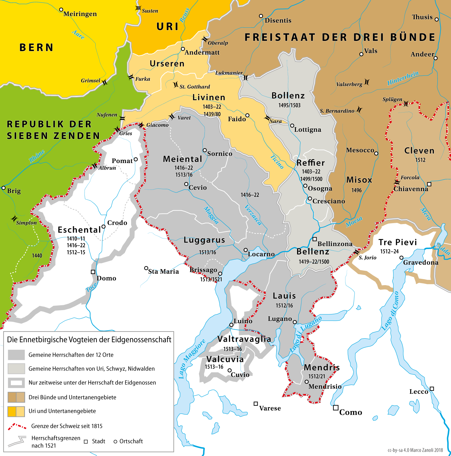
| DescriptionKarte Ennetbirgische Vogteien.png | Karte der Ennetbirgischen Vogteien der Eidgenossenschaft bis 1798 |
| Date | |
| Source | nach Adolf Gasser / Ernst Keller: Historische Karte zur territorialen Entwicklung der Schweizerischen Eidgenossenschaft 1291–1797, 1932. |
| Author | Marco Zanoli (sidonius 09:19, 30 May 2006 (UTC)) |
| Other versions |
|

Licensing
You may use my work outside wikipedia for free as long as you name me as the author. If you would like to use my work in a print medium, please send me a specimen copy.
Contact me if you have questions regarding the license or if you want individual changes to the map (marco.zanoli at hotmail.ch). This file is licensed under the Creative Commons Attribution-Share Alike 4.0 International license. Attribution: Marco Zanoli
|
Captions
Add a one-line explanation of what this file represents
Items portrayed in this file
depicts
30 May 2006
File history
Click on a date/time to view the file as it appeared at that time.
| Date/Time | Thumbnail | Dimensions | User | Comment | |
|---|---|---|---|---|---|
| current | 16:22, 16 December 2018 | | 1,500 × 1,516 (570 KB) | Sidonius | Revidierte Version, einige Fehler behoben, Ausschnitt verkleinert, |
| 21:14, 7 June 2015 |  | 1,548 × 1,536 (346 KB) | Cmdrjameson | Compressed with pngout. Reduced by 194kB (35% decrease). | |
| 20:22, 22 October 2012 |  | 1,548 × 1,536 (541 KB) | Sidonius | -Fehler in Legende behoben -zusätzliche Pässe eingefügt -Rahmen entfernt -kleinere Anpassungen im Layout und in der Karte | |
| 04:51, 4 July 2010 |  | 1,500 × 1,488 (816 KB) | DcoetzeeBot | Remove watermark, add author and license data to image metadata, decrease filesize with pngcrush | |
| 09:19, 30 May 2006 |  | 1,500 × 1,488 (950 KB) | Sidonius | {{Information| |Description=Karte der Ennetbirgischen Vogteien der Alten Eidgenossenschaft 1403–1798 |Source=nach Adolf Gasser / Ernst Keller: Historische Karte zur territorialen Entwicklung der Schweizerischen Eidgenossenschaft 1291–1797, 1932 |Date= |
File usage
The following pages on the English Wikipedia use this file (pages on other projects are not listed):
Global file usage
The following other wikis use this file:
- Usage on als.wikipedia.org
- Usage on bar.wikipedia.org
- Usage on cs.wikipedia.org
- Usage on de.wikipedia.org
- 1403
- Kanton Tessin
- Alte Eidgenossenschaft
- Gemeine Herrschaft
- Schlacht bei Marignano
- Benutzer:Sidonius
- Ennetbergische Vogteien
- Ossolatal
- Geschichte des Kantons Tessin
- Schlacht bei Arbedo
- Ennetbirgische Feldzüge
- Val Travaglia
- Val Cuvia
- Schweizer Truppen in päpstlichen Diensten
- Ewige Richtung mit Frankreich
- Usage on et.wikipedia.org
- Usage on fr.wikipedia.org
- Usage on he.wikivoyage.org
- Usage on hr.wikipedia.org
- Usage on nl.wikipedia.org
- Usage on ru.wikipedia.org
Metadata
This file contains additional information, probably added from the digital camera or scanner used to create or digitize it.
If the file has been modified from its original state, some details may not fully reflect the modified file.
| Copyright holder |
|
|---|---|
| Image title |
|
| Software used |
Retrieved from "https://en.wikipedia.org/wiki/File:Karte_Ennetbirgische_Vogteien.png"