File:Kurarivermap.jpg
From Wikipedia, the free encyclopedia
Size of this preview: 800 × 467 pixels. Other resolutions: 320 × 187 pixels | 640 × 373 pixels | 1,024 × 598 pixels | 1,484 × 866 pixels.
Original file (1,484 × 866 pixels, file size: 1.57 MB, MIME type: image/jpeg)
| This is a file from the Wikimedia Commons. Information from its description page there is shown below. Commons is a freely licensed media file repository. You can help. |
Summary
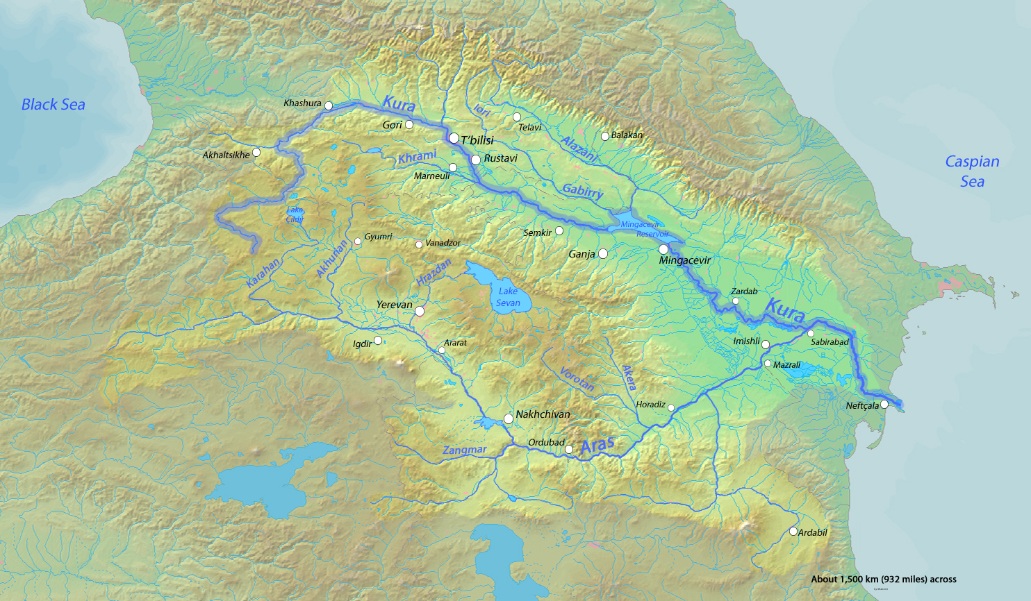
| DescriptionKurarivermap.jpg |
English: Map of the Kura River, whose watershed drains much of the Caucasus region in Azerbaijan, Georgia, Armenia, Turkey and Iran into the Caspian Sea |
| Date | |
| Source | Background and river course data from http://www2.demis.nl/mapserver/mapper.asp |
| Author | Shannon |
Licensing
I, the copyright holder of this work, hereby publish it under the following licenses:

|
Permission is granted to copy, distribute and/or modify this document under the terms of the GNU Free Documentation License, Version 1.2 or any later version published by the Free Software Foundation; with no Invariant Sections, no Front-Cover Texts, and no Back-Cover Texts. A copy of the license is included in the section entitled GNU Free Documentation License.http://www.gnu.org/copyleft/fdl.htmlGFDLGNU Free Documentation Licensetruetrue |
This file is licensed under the Creative Commons Attribution-Share Alike Attribution-Share Alike 4.0 International, 3.0 Unported, 2.5 Generic, 2.0 Generic and 1.0 Generic license.
- You are free:
- to share – to copy, distribute and transmit the work
- to remix – to adapt the work
- Under the following conditions:
- attribution – You must give appropriate credit, provide a link to the license, and indicate if changes were made. You may do so in any reasonable manner, but not in any way that suggests the licensor endorses you or your use.
- share alike – If you remix, transform, or build upon the material, you must distribute your contributions under the same or compatible license as the original.
You may select the license of your choice.
Captions
Add a one-line explanation of what this file represents
Items portrayed in this file
depicts
10 March 2010
File history
Click on a date/time to view the file as it appeared at that time.
| Date/Time | Thumbnail | Dimensions | User | Comment | |
|---|---|---|---|---|---|
| current | 01:16, 18 October 2013 | | 1,484 × 866 (1.57 MB) | Shannon1 | fixed location of Hrazdan River |
| 02:47, 12 March 2010 |  | 1,484 × 866 (783 KB) | Shannon1 | {{Information |Description={{en|1=Map of the Kura River, whose watershed drains much of the Caucasus region in Azerbaijan, Georgia, Armenia, Turkey and Iran into the Caspian Sea}} |Source=Background and river course data from http://www2.demis.nl/mapserve |
File usage
The following pages on the English Wikipedia use this file (pages on other projects are not listed):
Global file usage
The following other wikis use this file:
- Usage on af.wikipedia.org
- Usage on ar.wikipedia.org
- Usage on av.wikipedia.org
- Usage on az.wikipedia.org
- Usage on az.wiktionary.org
- Usage on be.wikipedia.org
- Usage on bg.wikipedia.org
- Usage on ca.wikipedia.org
- Usage on ceb.wikipedia.org
- Usage on cs.wikipedia.org
- Usage on da.wikipedia.org
- Usage on de.wikipedia.org
- Usage on eo.wikipedia.org
- Usage on es.wikipedia.org
- Usage on et.wikipedia.org
- Usage on eu.wikipedia.org
- Usage on frr.wikipedia.org
- Usage on fr.wikipedia.org
View more global usage of this file.
Metadata
This file contains additional information, probably added from the digital camera or scanner used to create or digitize it.
If the file has been modified from its original state, some details may not fully reflect the modified file.
| Orientation | Normal |
|---|---|
| Horizontal resolution | 72 dpi |
| Vertical resolution | 72 dpi |
| Software used | Adobe Photoshop CS5.1 Macintosh |
| File change date and time | 18:12, 17 October 2013 |
| Color space | sRGB |
| Date and time of digitizing | 12:02, 10 March 2010 |
| Date metadata was last modified | 11:12, 17 October 2013 |
| Unique ID of original document | uuid:72E2FDFFA02BDF11818AA02784CD2432 |
| Copyright status | Copyright status not set |
Retrieved from "https://en.wikipedia.org/wiki/File:Kurarivermap.jpg"