File:Map_Crusader_states_1197-en.svg
From Wikipedia, the free encyclopedia

Size of this PNG preview of this SVG file: 440 × 599 pixels. Other resolutions: 176 × 240 pixels | 353 × 480 pixels | 564 × 768 pixels | 752 × 1,024 pixels | 1,505 × 2,048 pixels | 507 × 690 pixels.
Original file (SVG file, nominally 507 × 690 pixels, file size: 76 KB)
| This is a file from the Wikimedia Commons. Information from its description page there is shown below. Commons is a freely licensed media file repository. You can help. |
Summary
| DescriptionMap Crusader states 1197-en.svg |
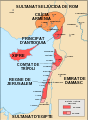
Français : Carte politique du Proche-Orient en 1197-1205 Русский: Карта Ближнего Востока, 1197-1205 г. |
| Date | |
| Source |
This file was derived from: Map Crusader states 1197-fr.svg:  |
| Author |
|
| Other versions |
[edit]
See also |


Licensing
I, the copyright holder of this work, hereby publish it under the following licenses:

|
Permission is granted to copy, distribute and/or modify this document under the terms of the GNU Free Documentation License, Version 1.2 or any later version published by the Free Software Foundation; with no Invariant Sections, no Front-Cover Texts, and no Back-Cover Texts. A copy of the license is included in the section entitled GNU Free Documentation License.http://www.gnu.org/copyleft/fdl.htmlGFDLGNU Free Documentation Licensetruetrue |
This file is licensed under the Creative Commons Attribution-Share Alike 3.0 Unported, 2.5 Generic, 2.0 Generic and 1.0 Generic license.
- You are free:
- to share – to copy, distribute and transmit the work
- to remix – to adapt the work
- Under the following conditions:
- attribution – You must give appropriate credit, provide a link to the license, and indicate if changes were made. You may do so in any reasonable manner, but not in any way that suggests the licensor endorses you or your use.
- share alike – If you remix, transform, or build upon the material, you must distribute your contributions under the same or compatible license as the original.
You may select the license of your choice.
Captions
Add a one-line explanation of what this file represents
Items portrayed in this file
depicts
23 May 2021
image/svg+xml
File history
Click on a date/time to view the file as it appeared at that time.
| Date/Time | Thumbnail | Dimensions | User | Comment | |
|---|---|---|---|---|---|
| current | 01:05, 1 June 2021 | | 507 × 690 (76 KB) | Akeosnhaoe | {{Information |description={{en|1=A political map of the Near East in 1197-1205 CE.}}{{fr|1=Carte politique du Proche-Orient en 1197-1205}}{{ru|1=Карта Ближнего Востока, 1197-1205 г.}} |date=2021-05-23 |source={{Derived from|Map Crusader states 1197-fr.svg|display=50}} |author=*Map Crusader states 1197-fr.svg: Odejea *derivative work: [[User:Akeosnhao... |
File usage
The following pages on the English Wikipedia use this file (pages on other projects are not listed):
Global file usage
The following other wikis use this file:
- Usage on it.wikipedia.org
- Usage on zh.wikipedia.org
Metadata
This file contains additional information, probably added from the digital camera or scanner used to create or digitize it.
If the file has been modified from its original state, some details may not fully reflect the modified file.
| Width | 506.58176 |
|---|---|
| Height | 690.2243 |
Retrieved from "https://en.wikipedia.org/wiki/File:Map_Crusader_states_1197-en.svg"