File:Map_Frank_campaigns_in_Aquitaine_507-509-fr.svg
From Wikipedia, the free encyclopedia

Original file (SVG file, nominally 755 × 784 pixels, file size: 505 KB)
| This is a file from the Wikimedia Commons. Information from its description page there is shown below. Commons is a freely licensed media file repository. You can help. |
Summary
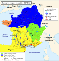
| DescriptionMap Frank campaigns in Aquitaine 507-509-fr.svg |
Català: Campanyes franques a Aquitània (507-509).
Français : Campagnes franques en Aquitaine (507-509). |
| Date | 06.03.2010 |
| Source | Travail personnel sur un fond de carte hydrographique de historicair. D'après Michel Rouche, Des Wisigoths aux Arabes, l'Aquitaine 418-781 : naissance d'une région, École des Hautes Études en Sciences Sociales, Jean Touzot, 1979, p. 53 et Clovis, éditions Fayard, 1996, p. 310. |
| Author | Romain0 |
| Other versions |
Other related versions:[edit]
|


_de.svg)
| This SVG file contains embedded text that can be translated into your language, using any capable SVG editor, text editor or the SVG Translate tool. For more information see: About translating SVG files. |
This file is translated using SVG <switch> elements. All translations are stored in the same file! Learn more.
For most Wikipedia projects, you can embed the file normally (without a To translate the text into your language, you can use the SVG Translate tool. Alternatively, you can download the file to your computer, add your translations using whatever software you're familiar with, and re-upload it with the same name. You will find help in Graphics Lab if you're not sure how to do this. |
Licensing
| Public domainPublic domainfalsefalse |
| I, the copyright holder of this work, release this work into the public domain. This applies worldwide. In some countries this may not be legally possible; if so: I grant anyone the right to use this work for any purpose, without any conditions, unless such conditions are required by law. |
Captions
Items portrayed in this file
depicts
File history
Click on a date/time to view the file as it appeared at that time.
| Date/Time | Thumbnail | Dimensions | User | Comment | |
|---|---|---|---|---|---|
| current | 21:26, 28 January 2024 | | 755 × 784 (505 KB) | Manlleus | fixed switch nodes for translation |
| 00:37, 27 January 2024 |  | 755 × 784 (539 KB) | Manlleus | File uploaded using svgtranslate tool (https://svgtranslate.toolforge.org/). Added translation for ca. | |
| 17:11, 6 May 2010 |  | 755 × 784 (536 KB) | Romain0 | Légende. | |
| 09:46, 1 May 2010 |  | 755 × 784 (523 KB) | Romain0 | Légendes + rivières. | |
| 09:37, 27 March 2010 |  | 755 × 784 (529 KB) | Romain0 | Légende. | |
| 20:59, 8 March 2010 |  | 755 × 784 (527 KB) | Romain0 | Taille de texte. | |
| 20:56, 8 March 2010 |  | 755 × 784 (515 KB) | Romain0 | Taille des flèches. | |
| 22:02, 6 March 2010 |  | 755 × 784 (527 KB) | Romain0 | Frontières et légendes. | |
| 20:49, 6 March 2010 |  | 755 × 784 (566 KB) | Romain0 | Légende. | |
| 20:43, 6 March 2010 |  | 755 × 784 (555 KB) | Romain0 | {{Information |Description={{fr|1=Campagnes franques en Aquitaine (507-509).}} |Source=Travail personnel sur un fond de carte hydrographique de historicair. D'après Michel Rouche, Des Wisigoths aux Arabes, l'Aquitaine 418-781 : naiss |
File usage
Global file usage
The following other wikis use this file:
- Usage on br.wikipedia.org
- Usage on ca.wikipedia.org
- Usage on el.wikipedia.org
- Usage on eo.wikipedia.org
- Usage on es.wikipedia.org
- Usage on fr.wikipedia.org
- Usage on gl.wikipedia.org
- Usage on hu.wikipedia.org
- Usage on ka.wikipedia.org
- Usage on nl.wikipedia.org
- Usage on oc.wikipedia.org
Metadata
This file contains additional information, probably added from the digital camera or scanner used to create or digitize it.
If the file has been modified from its original state, some details may not fully reflect the modified file.
| Width | 754.55359 |
|---|---|
| Height | 783.84796 |