File:Map_of_NATO_chronological.gif
From Wikipedia, the free encyclopedia
No higher resolution available.
Map_of_NATO_chronological.gif (743 × 284 pixels, file size: 135 KB, MIME type: image/gif, looped, 36 frames, 1 min 3 s)
| This is a file from the Wikimedia Commons. Information from its description page there is shown below. Commons is a freely licensed media file repository. You can help. |
Summary
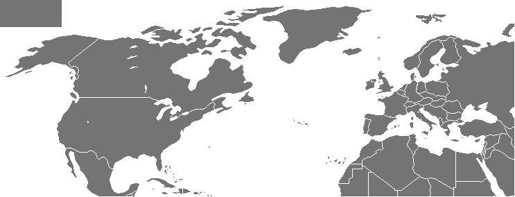
| DescriptionMap of NATO chronological.gif | |
| Date | |
| Source | based on Image:Map of NATO countries.png |
| Author | Arz |

|
This file has been superseded by History of NATO enlargement animation.gif. It is recommended to use the other file. Please note that deleting superseded images requires consent.
|

|
Licensing

|
Permission is granted to copy, distribute and/or modify this document under the terms of the GNU Free Documentation License, Version 1.2 or any later version published by the Free Software Foundation; with no Invariant Sections, no Front-Cover Texts, and no Back-Cover Texts. A copy of the license is included in the section entitled GNU Free Documentation License.http://www.gnu.org/copyleft/fdl.htmlGFDLGNU Free Documentation Licensetruetrue |
| This file is licensed under the Creative Commons Attribution-Share Alike 3.0 Unported license. | ||
| ||
| This licensing tag was added to this file as part of the GFDL licensing update.http://creativecommons.org/licenses/by-sa/3.0/CC BY-SA 3.0Creative Commons Attribution-Share Alike 3.0truetrue |
Captions
Map of NATO members over time, 1949 to 2024
Анімована карта розширення НАТО
Анимационная карта расширения межправительственного военного союза НАТО с момента его основания до 2020 года.
Karte der NATO-Mitglieder im Zeitverlauf, 1949 - April 2023
2 May 2007
image/gif
File history
Click on a date/time to view the file as it appeared at that time.
| Date/Time | Thumbnail | Dimensions | User | Comment | |
|---|---|---|---|---|---|
| current | 07:19, 15 March 2024 | 743 × 284 (135 KB) | Arz | +Sweeden | |
| 15:55, 4 April 2023 | 743 × 284 (136 KB) | Patrickneil | minus extra frame | ||
| 15:49, 4 April 2023 | 743 × 284 (139 KB) | Patrickneil | updating for 2023, but for crying out loud, would someone recreate this as an SVG animation? | ||
| 01:58, 10 October 2022 | 742 × 283 (137 KB) | Dylmur | Reverted to version as of 14:18, 13 April 2020 (UTC) | ||
| 11:39, 9 October 2022 | 743 × 284 (438 KB) | Italyoz484 | Sweden & Finland | ||
| 14:18, 13 April 2020 | 742 × 283 (137 KB) | Kaidor | + North Macedonia - 2020 | ||
| 00:14, 12 March 2018 | 742 × 283 (316 KB) | FreshCorp619 | Updated to include Algeria. | ||
| 01:52, 6 June 2017 | 742 × 283 (50 KB) | Patrickneil | fixing Montenegro borders in 2009 frame | ||
| 01:46, 6 June 2017 | 742 × 283 (50 KB) | Patrickneil | Adding Montenegro | ||
| 05:58, 6 July 2009 | 742 × 283 (49 KB) | Thingg | correction |
File usage
The following pages on the English Wikipedia use this file (pages on other projects are not listed):
Global file usage
The following other wikis use this file:
- Usage on af.wikipedia.org
- Usage on ar.wikipedia.org
- Usage on azb.wikipedia.org
- Usage on az.wikipedia.org
- Usage on be.wikipedia.org
- Usage on bg.wikipedia.org
- Usage on bh.wikipedia.org
- Usage on bs.wikipedia.org
- Usage on ca.wikipedia.org
- Usage on ckb.wikipedia.org
- Usage on cs.wikipedia.org
- Usage on cy.wikipedia.org
- Usage on da.wikipedia.org
- Usage on de.wikipedia.org
- Usage on el.wikipedia.org
- Usage on eo.wikipedia.org
- Usage on es.wikipedia.org
- Usage on et.wikipedia.org
- Usage on eu.wikipedia.org
- Usage on fa.wikipedia.org
- Usage on fr.wikipedia.org
- Usage on gl.wikipedia.org
- Usage on he.wikipedia.org
- Usage on hr.wikipedia.org
- Usage on hu.wikipedia.org
- Usage on hy.wikipedia.org
- Usage on id.wikipedia.org
- Usage on it.wikipedia.org
- Usage on ja.wikipedia.org
View more global usage of this file.
Metadata
This file contains additional information, probably added from the digital camera or scanner used to create or digitize it.
If the file has been modified from its original state, some details may not fully reflect the modified file.
| Software used | Adobe Photoshop 25.5 (Macintosh) |
|---|
Retrieved from "https://en.wikipedia.org/wiki/File:Map_of_NATO_chronological.gif"