File:Metro_Lisboa_Route_Map.png
From Wikipedia, the free encyclopedia
Size of this preview: 573 × 600 pixels. Other resolutions: 229 × 240 pixels | 459 × 480 pixels | 734 × 768 pixels | 978 × 1,024 pixels | 1,506 × 1,576 pixels.
Original file (1,506 × 1,576 pixels, file size: 269 KB, MIME type: image/png)
| This is a file from the Wikimedia Commons. Information from its description page there is shown below. Commons is a freely licensed media file repository. You can help. |
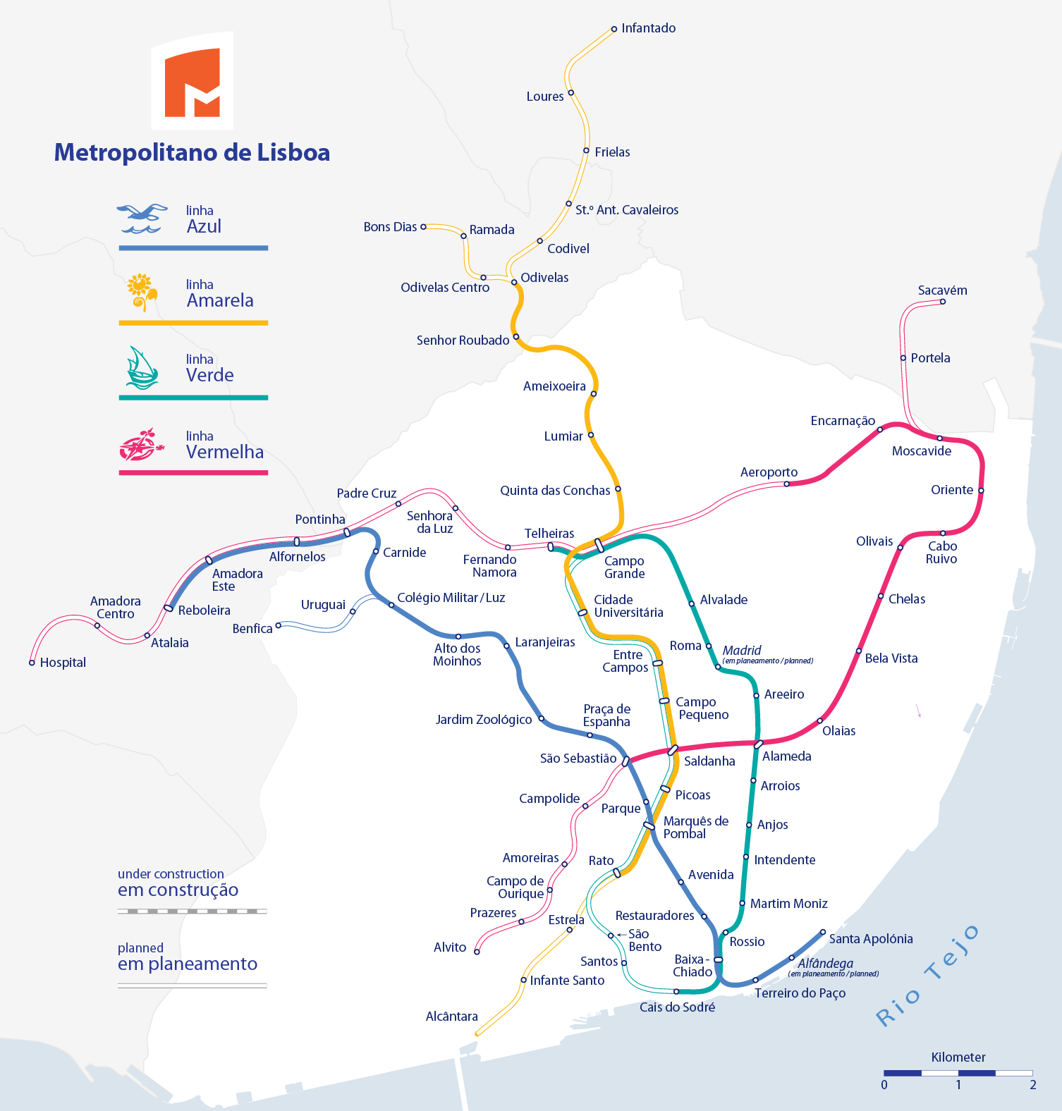
| DescriptionMetro Lisboa Route Map.png |
|
|||
| Date | ||||
| Source |
Self made, using the information from and using the following logos:
Created with Adobe Illustrator 12.0 If you ask for, I will give you the .ai-file or I'll correct it or create other language versions. |
|||
| Author | Maximilian Dörrbecker (Chumwa) | |||
| Permission (Reusing this file) |
I, the copyright holder of this work, hereby publish it under the following license: This file is licensed under the Creative Commons Attribution-Share Alike 2.5 Generic license.
Sie dürfen das Bild zu den folgenden Bedingungen nutzen:
|
|||
| Other versions |
|
.png)

.png)


Captions
Add a one-line explanation of what this file represents
Items portrayed in this file
depicts
File history
Click on a date/time to view the file as it appeared at that time.
| Date/Time | Thumbnail | Dimensions | User | Comment | |
|---|---|---|---|---|---|
| current | 18:01, 27 May 2016 | | 1,506 × 1,576 (269 KB) | Chumwa | Verlängerung nach Reboleira eröffnet |
| 04:51, 31 July 2012 |  | 1,506 × 1,576 (269 KB) | Chumwa | Strecke zum Flughafen ist jetzt eröffnet | |
| 04:50, 31 July 2012 |  | 1,506 × 1,576 (269 KB) | Chumwa | Strecke zum Flughafen ist jetzt eröffnet | |
| 21:05, 24 January 2011 |  | 1,506 × 1,576 (287 KB) | Chumwa | Estrela soll nun über die gelbe Linie von Rato aus erschlossen werden | |
| 08:15, 25 October 2009 |  | 1,506 × 1,576 (286 KB) | Chumwa | Amadora Este - Reboleira als im Bau befindlich ergänzt | |
| 16:19, 24 October 2009 |  | 1,506 × 1,576 (285 KB) | Chumwa | diverse Korrekturen (vielen Dank an jcornelius für die Hinweise!) | |
| 18:41, 22 October 2009 |  | 1,506 × 1,576 (274 KB) | Chumwa | update | |
| 00:12, 21 October 2009 |  | 978 × 957 (99 KB) | Javitomad | ¿Oriente-Aeroporto? (and repairing Alameda-SãoSebastião drawing) | |
| 20:39, 2 September 2009 |  | 978 × 957 (103 KB) | João P. M. Lima | linhas planeadas já não correspondem exactamente ao apresentado no plano de expansão 2010/2020, retiro essas linhas, pois também já existe um mapa para as expansões (obras em curso ficam no mapa) | |
| 15:53, 29 August 2009 |  | 978 × 957 (117 KB) | João P. M. Lima | carrego outra vez porque acho que à primeira não funcionou |
File usage
The following pages on the English Wikipedia use this file (pages on other projects are not listed):
Global file usage
The following other wikis use this file:
- Usage on ca.wikipedia.org
- Usage on de.wikipedia.org
- Usage on eo.wikipedia.org
- Usage on es.wikipedia.org
- Usage on fi.wikipedia.org
- Usage on fr.wikipedia.org
- Usage on hu.wikipedia.org
- Usage on ja.wikipedia.org
- Usage on ka.wikipedia.org
- Usage on nl.wikipedia.org
- Usage on pt.wikipedia.org
- Usage on ru.wikipedia.org
- Usage on sv.wikipedia.org
- Usage on tl.wikipedia.org
- Usage on tr.wikipedia.org
- Usage on uk.wikipedia.org
Metadata
This file contains additional information, probably added from the digital camera or scanner used to create or digitize it.
If the file has been modified from its original state, some details may not fully reflect the modified file.
| Horizontal resolution | 78.74 dpc |
|---|---|
| Vertical resolution | 78.74 dpc |
| Software used |
Retrieved from "https://en.wikipedia.org/wiki/File:Metro_Lisboa_Route_Map.png"