File:Morocco_and_the_Maghreb_after_the_Berber_Revolt.PNG
From Wikipedia, the free encyclopedia
No higher resolution available.
Morocco_and_the_Maghreb_after_the_Berber_Revolt.PNG (636 × 371 pixels, file size: 17 KB, MIME type: image/png)
| This is a file from the Wikimedia Commons. Information from its description page there is shown below. Commons is a freely licensed media file repository. You can help. |
Summary
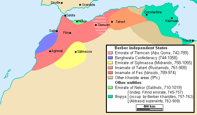
| DescriptionMorocco and the Maghreb after the Berber Revolt.PNG |
English: Morocco and the Maghreb after the Berber Revolt, own made map based on : Georges Duby, Atlas Historique Mondial, Ed. Larousse (2000), pp.220 & 224, ISBN:2702828655 Julien Loiseau, Comment l'Afrique du Nord est passée à l'islam, dans : Les Collections de L'Histoire n°78, janvier-mars 2018 [1] |
| Date | |
| Source | Own work |
| Author | Omar-toons |
| Other versions | العربيَّة |
Licensing
I, the copyright holder of this work, hereby publish it under the following license:
This file is licensed under the Creative Commons Attribution-Share Alike 3.0 Unported license.
- You are free:
- to share – to copy, distribute and transmit the work
- to remix – to adapt the work
- Under the following conditions:
- attribution – You must give appropriate credit, provide a link to the license, and indicate if changes were made. You may do so in any reasonable manner, but not in any way that suggests the licensor endorses you or your use.
- share alike – If you remix, transform, or build upon the material, you must distribute your contributions under the same or compatible license as the original.
Captions
Add a one-line explanation of what this file represents
Items portrayed in this file
depicts
18 April 2013
File history
Click on a date/time to view the file as it appeared at that time.
| Date/Time | Thumbnail | Dimensions | User | Comment | |
|---|---|---|---|---|---|
| current | 11:06, 6 April 2017 | | 636 × 371 (17 KB) | Omar-toons | +Other kharijite areas |
| 08:58, 6 April 2017 |  | 636 × 371 (16 KB) | Omar-toons | min. ch. | |
| 11:09, 1 November 2014 |  | 636 × 371 (18 KB) | Omar-toons | reduc. size | |
| 10:44, 1 November 2014 |  | 636 × 419 (19 KB) | Omar-toons | + detils on pre-Aghlabid Ifriqiya | |
| 20:52, 18 April 2013 |  | 636 × 382 (17 KB) | Omar-toons | larger area for the Barghwatas, Salé and Souss to Idrisids | |
| 20:27, 18 April 2013 |  | 636 × 382 (17 KB) | Omar-toons | min. ch. | |
| 17:59, 18 April 2013 |  | 636 × 382 (17 KB) | Omar-toons | +Rustamid hold over the coastal area | |
| 17:28, 18 April 2013 |  | 636 × 382 (17 KB) | Omar-toons | User created page with UploadWizard |
File usage
The following pages on the English Wikipedia use this file (pages on other projects are not listed):
Global file usage
The following other wikis use this file:
- Usage on de.wikipedia.org
- Usage on et.wikipedia.org
- Usage on eu.wikipedia.org
- Usage on fi.wikipedia.org
- Usage on fr.wikipedia.org
- Usage on it.wikipedia.org
- Usage on ka.wikipedia.org
- Usage on ko.wikipedia.org
- Usage on la.wikipedia.org
- Usage on lt.wikipedia.org
- Usage on mt.wikipedia.org
- Usage on nl.wikipedia.org
Metadata
This file contains additional information, probably added from the digital camera or scanner used to create or digitize it.
If the file has been modified from its original state, some details may not fully reflect the modified file.
| Horizontal resolution | 37.8 dpc |
|---|---|
| Vertical resolution | 37.8 dpc |