File:Neighborhoods_Evacuated_as_Kincade_Fire_Spreads_(48953815948).jpg
From Wikipedia, the free encyclopedia
Size of this preview: 800 × 450 pixels. Other resolutions: 320 × 180 pixels | 640 × 360 pixels | 1,024 × 576 pixels | 1,280 × 720 pixels | 1,920 × 1,080 pixels.
Original file (1,920 × 1,080 pixels, file size: 972 KB, MIME type: image/jpeg)
| This is a file from the Wikimedia Commons. Information from its description page there is shown below. Commons is a freely licensed media file repository. You can help. |
Summary
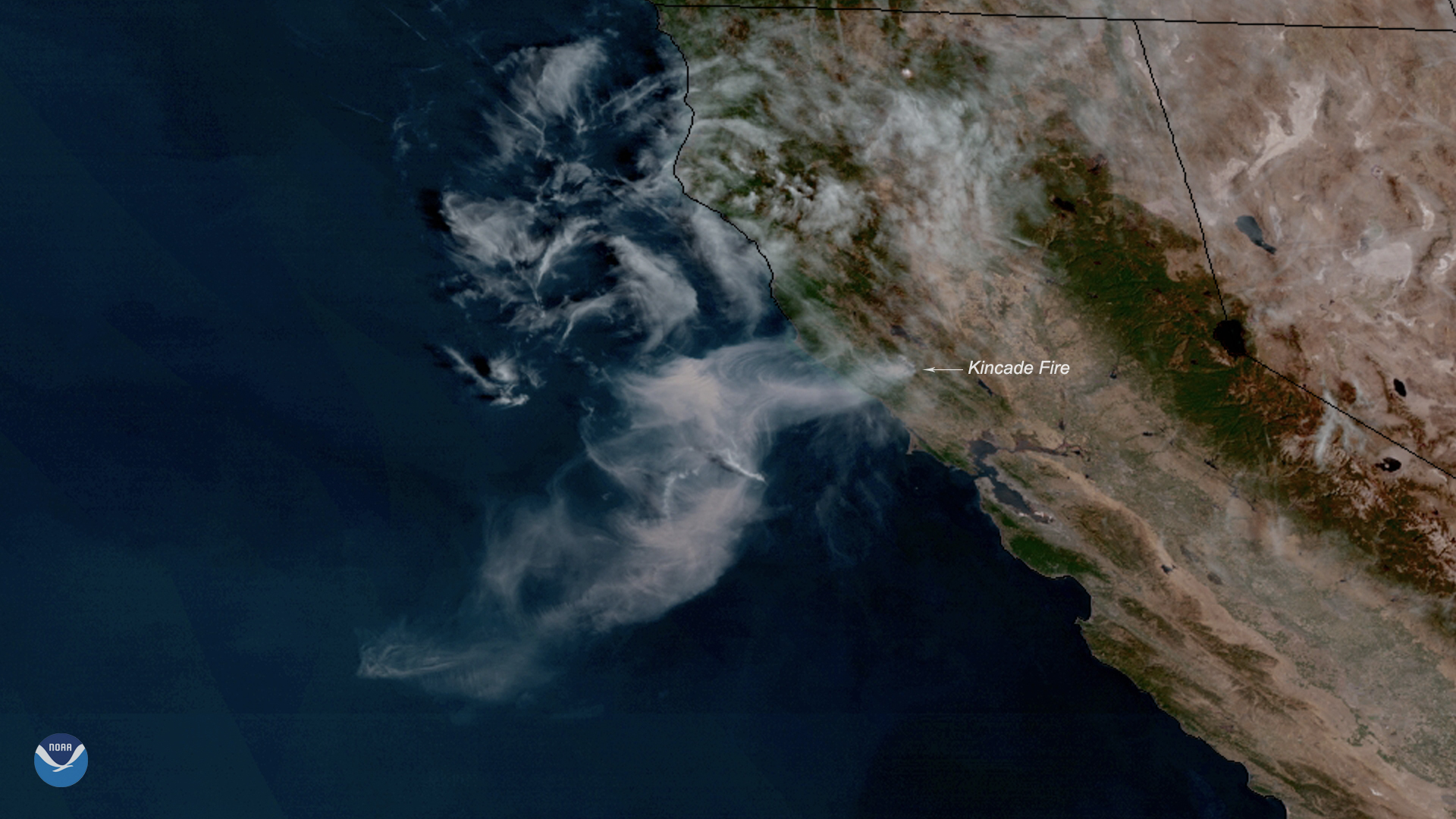
| DescriptionNeighborhoods Evacuated as Kincade Fire Spreads (48953815948).jpg | Neighborhoods across parts of Sonoma County, California, are under evacuation orders, and more are expected as the Kincade Fire continues to spread toward Cloverdale. The wildfire, seen here by NOAA's GOES West on Oct. 24, 2019, grew to 10,000 acres overnight, and wind gusts of 35-45 mph continue to aid its rapid expansion. The Kincade Fire was first reported around 9:30 p.m. PT on Wednesday just northeast of the town of Geyserville, according to a Cal Fire incident report. Early Thursday morning, the County of Sonoma issued a mandatory evacuation order for all Geyserville residents, noting that the fire had crossed Highway 128 near Moody Lane and was spreading westward. Much of the Sacramento area, which is located about 80 miles east of Geyserville, is under a Red Flag Warning until 4 p.m. This means critical fire weather conditions, which include a combination of strong winds, low relative humidity, and warm temperatures, are occurring or imminent, according to the National Weather Service. This GeoColor enhanced imagery was created by NOAA's partners at the Cooperative Institute for Research in the Atmosphere. The GOES West satellite, also known as GOES-17, provides geostationary satellite coverage of the Western Hemisphere, including the Western United States, the Pacific Ocean, Alaska, and Hawaii. First launched in March 2018, the satellite became fully operational in February 2019. |
| Date | |
| Source | Neighborhoods Evacuated as Kincade Fire Spreads |
| Author | NOAA Satellites |
Licensing
| Public domainPublic domainfalsefalse |
This image is in the public domain because it contains materials that originally came from the U.S. National Oceanic and Atmospheric Administration, taken or made as part of an employee's official duties.
العربية ∙ čeština ∙ Deutsch ∙ Zazaki ∙ English ∙ español ∙ eesti ∙ suomi ∙ français ∙ hrvatski ∙ magyar ∙ italiano ∙ 日本語 ∙ 한국어 ∙ македонски ∙ മലയാളം ∙ Plattdüütsch ∙ Nederlands ∙ polski ∙ português ∙ română ∙ русский ∙ sicilianu ∙ slovenščina ∙ Türkçe ∙ Tiếng Việt ∙ 简体中文 ∙ 繁體中文 ∙ +/− |
| This image was originally posted to Flickr by NOAASatellites at https://flickr.com/photos/125201706@N06/48953815948 (archive). It was reviewed on 29 October 2019 by FlickreviewR 2 and was confirmed to be licensed under the terms of the Public Domain Mark. |
29 October 2019
Captions
Add a one-line explanation of what this file represents
Items portrayed in this file
depicts
some value
24 October 2019
image/jpeg
158fe6f570f4816ededebd7ead04821c4a3138f8
995,155 byte
1,080 pixel
1,920 pixel
File history
Click on a date/time to view the file as it appeared at that time.
| Date/Time | Thumbnail | Dimensions | User | Comment | |
|---|---|---|---|---|---|
| current | 02:53, 29 October 2019 | | 1,920 × 1,080 (972 KB) | Daniel Mietchen | Transferred from Flickr via #flickr2commons |
File usage
The following pages on the English Wikipedia use this file (pages on other projects are not listed):
Global file usage
The following other wikis use this file:
- Usage on ko.wikipedia.org
- Usage on www.wikidata.org
Metadata
This file contains additional information, probably added from the digital camera or scanner used to create or digitize it.
If the file has been modified from its original state, some details may not fully reflect the modified file.
| Orientation | Normal |
|---|---|
| Software used | |
| Subsampling ratio of Y to C |
|
| Exif version | 2.2 |
.jpg)