File:North_Florida_map.png
From Wikipedia, the free encyclopedia
No higher resolution available.
North_Florida_map.png (520 × 500 pixels, file size: 63 KB, MIME type: image/png)
| This is a file from the Wikimedia Commons. Information from its description page there is shown below. Commons is a freely licensed media file repository. You can help. |
Summary
| DescriptionNorth Florida map.png |
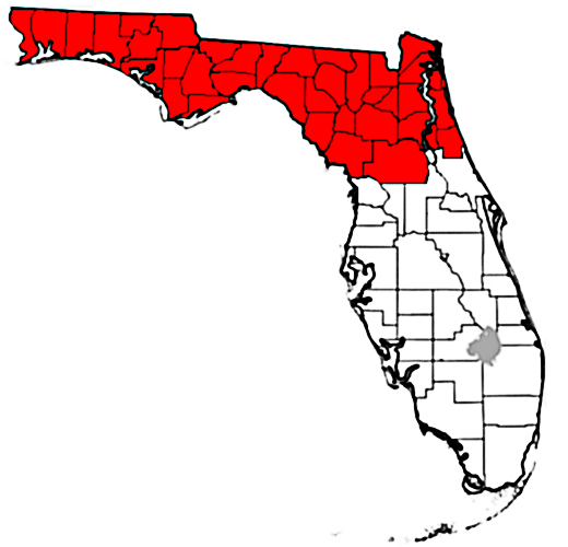
English: Encompasses the full definition of North Florida better than the previous map. |
| Date | |
| Source | Own work |
| Author | Mathew105601 |
Licensing
I, the copyright holder of this work, hereby publish it under the following license:
This file is licensed under the Creative Commons Attribution-Share Alike 3.0 Unported license.
- You are free:
- to share – to copy, distribute and transmit the work
- to remix – to adapt the work
- Under the following conditions:
- attribution – You must give appropriate credit, provide a link to the license, and indicate if changes were made. You may do so in any reasonable manner, but not in any way that suggests the licensor endorses you or your use.
- share alike – If you remix, transform, or build upon the material, you must distribute your contributions under the same or compatible license as the original.
Captions
Add a one-line explanation of what this file represents
Items portrayed in this file
depicts
some value
16 July 2013
File history
Click on a date/time to view the file as it appeared at that time.
| Date/Time | Thumbnail | Dimensions | User | Comment | |
|---|---|---|---|---|---|
| current | 18:42, 16 July 2013 | | 520 × 500 (63 KB) | Mathew105601 | Added Marion County to the area included in North Florida. |
| 18:36, 16 July 2013 |  | 520 × 500 (62 KB) | Mathew105601 | User created page with UploadWizard |
File usage
The following pages on the English Wikipedia use this file (pages on other projects are not listed):
- Alachua County, Florida
- Atlantic Beach, Florida
- Baker County, Florida
- Bay County, Florida
- Big Bend (Florida)
- Bradford County, Florida
- Calhoun County, Florida
- Callaway, Florida
- Clay County, Florida
- Columbia County, Florida
- Crestview, Florida
- Crestview–Fort Walton Beach–Destin metropolitan area
- Destin, Florida
- Dixie County, Florida
- Duval County, Florida
- Emerald Coast
- Escambia County, Florida
- Fernandina Beach, Florida
- First Coast
- Flagler County, Florida
- Florida panhandle
- Forgotten Coast
- Fort Walton Beach, Florida
- Franklin County, Florida
- Gadsden County, Florida
- Gainesville, Florida
- Gainesville metropolitan area, Florida
- Gilchrist County, Florida
- Gulf County, Florida
- Halifax area
- Hamilton County, Florida
- Holmes County, Florida
- Jackson County, Florida
- Jacksonville, Florida
- Jacksonville Beach, Florida
- Jacksonville metropolitan area
- Jefferson County, Florida
- Lafayette County, Florida
- Lake City, Florida
- Leon County, Florida
- Levy County, Florida
- Liberty County, Florida
- Lynn Haven, Florida
- Madison County, Florida
- Marion County, Florida
- Nassau County, Florida
- Nature Coast
- Niceville, Florida
- North Florida
- North central Florida
- Ocala, Florida
- Okaloosa County, Florida
- Palatka, Florida
- Palm Coast, Florida
- Panama City Beach, Florida
- Pensacola, Florida
- Pensacola metropolitan area
- Putnam County, Florida
- Santa Rosa County, Florida
- St. Augustine, Florida
- St. Johns County, Florida
- Suwannee County, Florida
- Tallahassee, Florida
- Tallahassee metropolitan area
- Taylor County, Florida
- Union County, Florida
- Wakulla County, Florida
- Walton County, Florida
- Washington County, Florida
- User:Alarob
- Template:North Florida
- Category:North Florida
Global file usage
The following other wikis use this file:
- Usage on pt.wikipedia.org
- Usage on tr.wikipedia.org
- Usage on www.wikidata.org
- Usage on zh.wikipedia.org
Retrieved from "https://en.wikipedia.org/wiki/File:North_Florida_map.png"