File:North_and_South_Luconia_Shoals.jpg
From Wikipedia, the free encyclopedia
Size of this preview: 331 × 600 pixels. Other resolutions: 132 × 240 pixels | 265 × 480 pixels | 423 × 768 pixels | 565 × 1,024 pixels | 1,280 × 2,320 pixels.
Original file (1,280 × 2,320 pixels, file size: 478 KB, MIME type: image/jpeg)
| This is a file from the Wikimedia Commons. Information from its description page there is shown below. Commons is a freely licensed media file repository. You can help. |
Summary
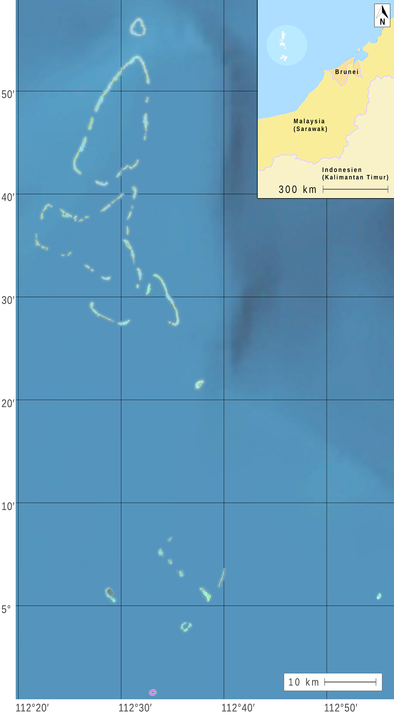
| DescriptionNorth and South Luconia Shoals.jpg |
Deutsch: Nördliche und Südliche Luconia-Untiefen (oder -Riffe, englisch Luconia Shoals) im Südchinesische Meer südwestlich der Spratly-Inseln auf dem Festlandsockel vor dem malaysischen Bundesstaat Sarawak. (Nach Satellitenbildern der Landsat 7 und weiteren Quellen.) English: Northern and Southern Luconia Shoals (or reefs) in the South China Sea southwest of the Spratly Islands to the continental shelf in front of the Malaysian state of Sarawak. (According to satellite images of Landsat 7 and other sources.) Français : Les bancs Luconia nord et sud (ou récifs, en anglais Luçon Shoals) dans la mer de Chine méridionale sud-ouest des îles Spratly sur le plateau continental en face de l'État malais du Sarawak. (Selon des images satellite Landsat 7 et d'autres sources.) |
| Date | |
| Source |
1) satellite images on oceandots.com |
| Author |
|
| This is a retouched picture, which means that it has been digitally altered from its original version. Modifications: Deutsch: Teile der angegebenen Quellen wurden zu einem neuen Bild zusammengestellt. English: Parts of the indicated sources were combined to form a new image. Français : Parties des sources indiquées ont été combinées pour former une nouvelle image. . Modifications made by MagentaGreen.
|
Licensing
| Public domainPublic domainfalsefalse |
| This file is in the public domain in the United States because it was solely created by NASA. NASA copyright policy states that "NASA material is not protected by copyright unless noted". (See Template:PD-USGov, NASA copyright policy page or JPL Image Use Policy.) | ||
 |
Warnings:
|
(1, 2)
Permission is granted to do what the fuck you want to with this document under the terms of the WTF Public License, Version 2.
| |
| WTF Public LicenseWTFPLfalsefalsehttp://www.wtfpl.net/about/ |
(3, 4)
| Annotations InfoField | This image is annotated: View the annotations at Commons |
403
41
84
95
1280
2320
Friedship Shoal
220
175
278
433
1280
2320
The Atoll as a whole only has a Chinese Name:
盟谊南 Méng yì nán (means Friendship South).
It contains, from north to south:
- Hardie Reef
- Aitken Reef
- Buck Reef
97
600
366
345
1280
2320
Moody Reef
456
882
137
190
1280
2320
Seahorse Breakers
273
970
162
95
1280
2320
Tripp Reef
604
1209
77
77
1280
2320
Hayes Reef
322
1892
70
70
1280
2320
Stigant Reef
491
1766
49
49
1280
2320
Connell Reef
574
2012
63
56
1280
2320
Herald Reef
1206
1906
49
63
1280
2320
Comus shoal
526
1730
42
42
1280
2320
N. n.
533
1801
42
42
1280
2320
N. n.
568
1843
42
42
1280
2320
N. n.
695
1832
56
92
1280
2320
Richmond Reef
628
1899
63
63
1280
2320
Luconia Breakers
283
1706
996
600
1280
2320
South Luconia Shoals
97
39
597
1267
1280
2320
North Luconia Shoals
464
2216
62
54
1280
2320
Sierra Blanca
Chinese: 澄平礁 Chéngpíng Jiāo
Captions
Add a one-line explanation of what this file represents
Items portrayed in this file
depicts
28 May 2015
File history
Click on a date/time to view the file as it appeared at that time.
| Date/Time | Thumbnail | Dimensions | User | Comment | |
|---|---|---|---|---|---|
| current | 10:31, 5 June 2015 | | 1,280 × 2,320 (478 KB) | MagentaGreen | Längen- und Breitengrade |
| 15:37, 28 May 2015 |  | 1,232 × 2,112 (326 KB) | MagentaGreen | =={{int:filedesc}}== {{Information |description={{de|1=Nördliche und Südliche Luconia-Untiefen (oder -Riffe, englisch Luconia Shoals) im Südchinesische Meer südwestlich der Spratly-Inseln auf dem Festlandsockel vor dem malaysischen Bundesstaat Sara... |
File usage
The following pages on the English Wikipedia use this file (pages on other projects are not listed):
Global file usage
The following other wikis use this file:
- Usage on de.wikipedia.org
- Usage on id.wikipedia.org
- Usage on ja.wikipedia.org
- Usage on ms.wikipedia.org
- Usage on sv.wikipedia.org
- Usage on zh.wikipedia.org