File:PlanoMontevideoSitioGrande.JPG
From Wikipedia, the free encyclopedia
Original file (924 × 657 pixels, file size: 147 KB, MIME type: image/jpeg)
| This is a file from the Wikimedia Commons. Information from its description page there is shown below. Commons is a freely licensed media file repository. You can help. |
Summary
| DescriptionPlanoMontevideoSitioGrande.JPG |
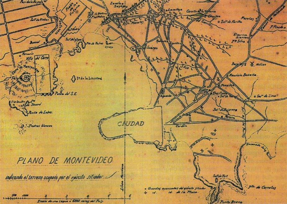
English: Former map of Montevideo (Uruguay) and surrounding towns (now converted into neighborhoods of the city), developed during the called Guerra Grande (Great War, 1843 - 1851), where the demarcation area occupied by the siege army of Montevideo.
Español: Mapa antiguo de Montevideo y pueblos aledaños (Pueblo de la Victoria, actual barrio de La Teja, y el hoy también barrio de Villa del Cerro) donde se indica el territorio ocupado por el ejército sitiador de Montevideo en el transcurso de la Guerra Grande. |
||||
| Date | Entre 1843 y 1851 (Período temporal de duración de la Guerra Grande) | ||||
| Source | Digitalizado del libro Gran Enciclopedia del Uruguay | ||||
| Author | Unknown authorUnknown author | ||||
| Other versions |
|

Licensing
| Public domainPublic domainfalsefalse |
|
This work is in the public domain in its country of origin and other countries and areas where the copyright term is the author's life plus 70 years or fewer.
| |
| This file has been identified as being free of known restrictions under copyright law, including all related and neighboring rights. | |
https://creativecommons.org/publicdomain/mark/1.0/PDMCreative Commons Public Domain Mark 1.0falsefalse
Captions
Items portrayed in this file
depicts
image/jpeg
File history
Click on a date/time to view the file as it appeared at that time.
| Date/Time | Thumbnail | Dimensions | User | Comment | |
|---|---|---|---|---|---|
| current | 22:15, 17 July 2008 | | 924 × 657 (147 KB) | Uruguayo-92 | {{Information |Description={{en|1=Former map of Montevideo (Uruguay) and surrounding towns (now converted into neighborhoods of the city), developed during the called ''Guerra Grande'' (Great War, 1843 - 1851), where the demarcation area occupied by the s |
File usage
Global file usage
The following other wikis use this file:
- Usage on de.wikipedia.org
- Usage on es.wikipedia.org
- Usage on ru.wikipedia.org
Metadata
This file contains additional information, probably added from the digital camera or scanner used to create or digitize it.
If the file has been modified from its original state, some details may not fully reflect the modified file.
| _error | 0 |
|---|