File:Popton_Fort_-_geograph.org.uk_-_1262954.jpg
From Wikipedia, the free encyclopedia
No higher resolution available.
Popton_Fort_-_geograph.org.uk_-_1262954.jpg (640 × 480 pixels, file size: 66 KB, MIME type: image/jpeg)
| This is a file from the Wikimedia Commons. Information from its description page there is shown below. Commons is a freely licensed media file repository. You can help. |
Summary
| DescriptionPopton Fort - geograph.org.uk - 1262954.jpg |
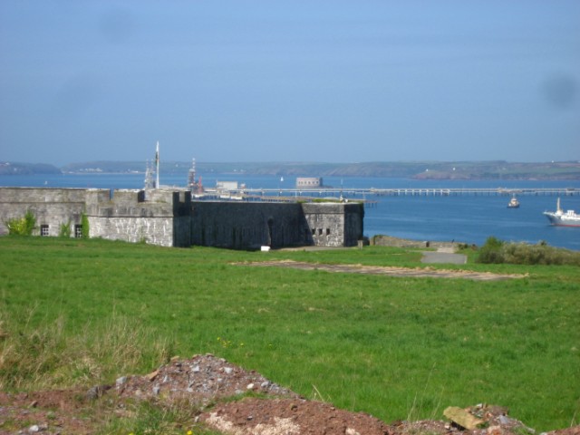
English: Popton Fort Part of the nineteenth century defences built around Milford haven. In later years the fort was used by the BP oil company as their offices for the oil terminal located below. For more detailed information about Popton this is an excellent link: http://www.texaco.co.uk/biodiversity/Manmade/popton.htm |
| Date | |
| Source | From geograph.org.uk |
| Author | Shaun Butler |
| Attribution (required by the license) InfoField | Shaun Butler / Popton Fort / |
InfoField | Shaun Butler / Popton Fort |
| Camera location | 51° 41′ 33″ N, 5° 02′ 39″ W | View this and other nearby images on: OpenStreetMap |
|---|
| Object location | 51° 41′ 34″ N, 5° 02′ 50″ W | View this and other nearby images on: OpenStreetMap |
|---|
Licensing

|
This image was taken from the Geograph project collection. See this photograph's page on the Geograph website for the photographer's contact details. The copyright on this image is owned by Shaun Butler and is licensed for reuse under the Creative Commons Attribution-ShareAlike 2.0 license.
|
This file is licensed under the Creative Commons Attribution-Share Alike 2.0 Generic license.
Attribution: Shaun Butler
- You are free:
- to share – to copy, distribute and transmit the work
- to remix – to adapt the work
- Under the following conditions:
- attribution – You must give appropriate credit, provide a link to the license, and indicate if changes were made. You may do so in any reasonable manner, but not in any way that suggests the licensor endorses you or your use.
- share alike – If you remix, transform, or build upon the material, you must distribute your contributions under the same or compatible license as the original.
Captions
Add a one-line explanation of what this file represents
Items portrayed in this file
depicts
some value
19 April 2009
51°41'32.71"N, 5°2'38.76"W
51°41'34.04"N, 5°2'50.28"W
File history
Click on a date/time to view the file as it appeared at that time.
| Date/Time | Thumbnail | Dimensions | User | Comment | |
|---|---|---|---|---|---|
| current | 00:12, 27 February 2011 | | 640 × 480 (66 KB) | GeographBot | == {{int:filedesc}} == {{Information |description={{en|1=Popton Fort Part of the nineteenth century defences built around Milford haven. In later years the fort was used by the BP oil company as their offices for the oil terminal located below. For more d |
File usage
The following pages on the English Wikipedia use this file (pages on other projects are not listed):
Global file usage
The following other wikis use this file:
- Usage on www.wikidata.org
Metadata
This file contains additional information, probably added from the digital camera or scanner used to create or digitize it.
If the file has been modified from its original state, some details may not fully reflect the modified file.
| Camera manufacturer | Canon |
|---|---|
| Camera model | Canon DIGITAL IXUS 800 IS |
| Exposure time | 1/500 sec (0.002) |
| F-number | f/5 |
| Date and time of data generation | 11:29, 19 April 2009 |
| Lens focal length | 18.633 mm |
| Orientation | Normal |
| Horizontal resolution | 180 dpi |
| Vertical resolution | 180 dpi |
| File change date and time | 11:29, 19 April 2009 |
| Y and C positioning | Centered |
| Custom image processing | Normal process |
| Exposure mode | Auto exposure |
| White balance | Manual white balance |
| Digital zoom ratio | 1 |
| Scene capture type | Landscape |
| Exif version | 2.2 |
| Date and time of digitizing | 11:29, 19 April 2009 |
| Image compression mode | 5 |
| Shutter speed | 8.96875 |
| APEX aperture | 4.65625 |
| Exposure bias | 0 |
| Maximum land aperture | 4.65625 APEX (f/5.02) |
| Metering mode | Pattern |
| Flash | Flash did not fire, compulsory flash suppression |
| Color space | sRGB |
| Focal plane X resolution | 12,515.555555556 |
| Focal plane Y resolution | 12,497.041420118 |
| Focal plane resolution unit | inches |
| Sensing method | One-chip color area sensor |