File:Shwesandaw_Pagoda_festival_in_Pyay,_Myanmar.jpg
From Wikipedia, the free encyclopedia
Original file (923 × 768 pixels, file size: 287 KB, MIME type: image/jpeg)
| This is a file from the Wikimedia Commons. Information from its description page there is shown below. Commons is a freely licensed media file repository. You can help. |
Summary
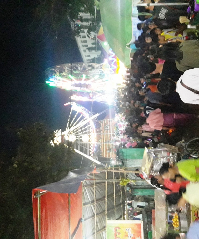
| DescriptionShwesandaw Pagoda festival in Pyay, Myanmar.jpg |
English: Shwesandaw Pagoda festival in Pyay, Myanmar
Pagoda festivals (Burmese: ဘုရားပွဲ) are regular festivals found throughout Burma (Myanmar) that commemorate major events in pagoda's history, including the founding of a pagoda and the crowning of the pagoda's hti (umbrella). Pagoda festivals are dictated by the Burmese religious calendar and often are held several days at a time. During pagoda festivals, temporary bazaars (including food stalls and merchandise stands), entertainment venues (including anyeint dramas, yoke the performances, lethwei matches and arcades) are set up in the vicinity of the pagoda. |
| Date | |
| Source | Own work |
| Author | Phyo WP |
| Camera location | 18° 49′ 19″ N, 95° 13′ 01″ E | View this and other nearby images on: OpenStreetMap |
|---|
Licensing
- You are free:
- to share – to copy, distribute and transmit the work
- to remix – to adapt the work
- Under the following conditions:
- attribution – You must give appropriate credit, provide a link to the license, and indicate if changes were made. You may do so in any reasonable manner, but not in any way that suggests the licensor endorses you or your use.
- share alike – If you remix, transform, or build upon the material, you must distribute your contributions under the same or compatible license as the original.
Captions
Items portrayed in this file
depicts
18°49'18.998"N, 95°13'0.998"E
17 November 2018
File history
Click on a date/time to view the file as it appeared at that time.
| Date/Time | Thumbnail | Dimensions | User | Comment | |
|---|---|---|---|---|---|
| current | 14:10, 6 December 2018 | | 923 × 768 (287 KB) | Phyo WP | User created page with UploadWizard |
File usage
Global file usage
The following other wikis use this file:
- Usage on bn.wikipedia.org
- Usage on my.wikipedia.org
Metadata
This file contains additional information, probably added from the digital camera or scanner used to create or digitize it.
If the file has been modified from its original state, some details may not fully reflect the modified file.
| Camera manufacturer | samsung |
|---|---|
| Camera model | SM-J710F |
| Exposure time | 1/17 sec (0.058823529411765) |
| F-number | f/1.9 |
| ISO speed rating | 640 |
| Date and time of data generation | 19:55, 17 November 2018 |
| Lens focal length | 3.7 mm |
| Latitude | 18° 49′ 19″ N |
| Longitude | 95° 13′ 1″ E |
| Altitude | 17 meters below sea level |
| Orientation | Rotated 90° CCW |
| Software used | J710FXXU4BRB2 |
| File change date and time | 19:55, 17 November 2018 |
| Y and C positioning | Centered |
| Exposure Program | Normal program |
| Exif version | 2.2 |
| Date and time of digitizing | 19:55, 17 November 2018 |
| Meaning of each component |
|
| Shutter speed | 4.06 |
| APEX aperture | 1.85 |
| APEX brightness | −2.02 |
| Exposure bias | 0 |
| Maximum land aperture | 1.85 APEX (f/1.9) |
| Metering mode | Center weighted average |
| Flash | Flash did not fire |
| DateTime subseconds | 0667 |
| DateTimeOriginal subseconds | 06 |
| DateTimeDigitized subseconds | 06 |
| Supported Flashpix version | 1 |
| Color space | sRGB |
| Exposure mode | Auto exposure |
| White balance | Auto white balance |
| Focal length in 35 mm film | 28 mm |
| Scene capture type | Standard |
| Unique image ID | V13LLIA02SM V13LLKG02SB |
| GPS time (atomic clock) | 13:21 |
| GPS date | 17 November 2018 |
| GPS tag version | 2.2.0.0 |