File:TotalTimingSystem.png
From Wikipedia, the free encyclopedia
Original file (1,650 × 2,550 pixels, file size: 2.29 MB, MIME type: image/png)
| This is a file from the Wikimedia Commons. Information from its description page there is shown below. Commons is a freely licensed media file repository. You can help. |
Summary
| DescriptionTotalTimingSystem.png |
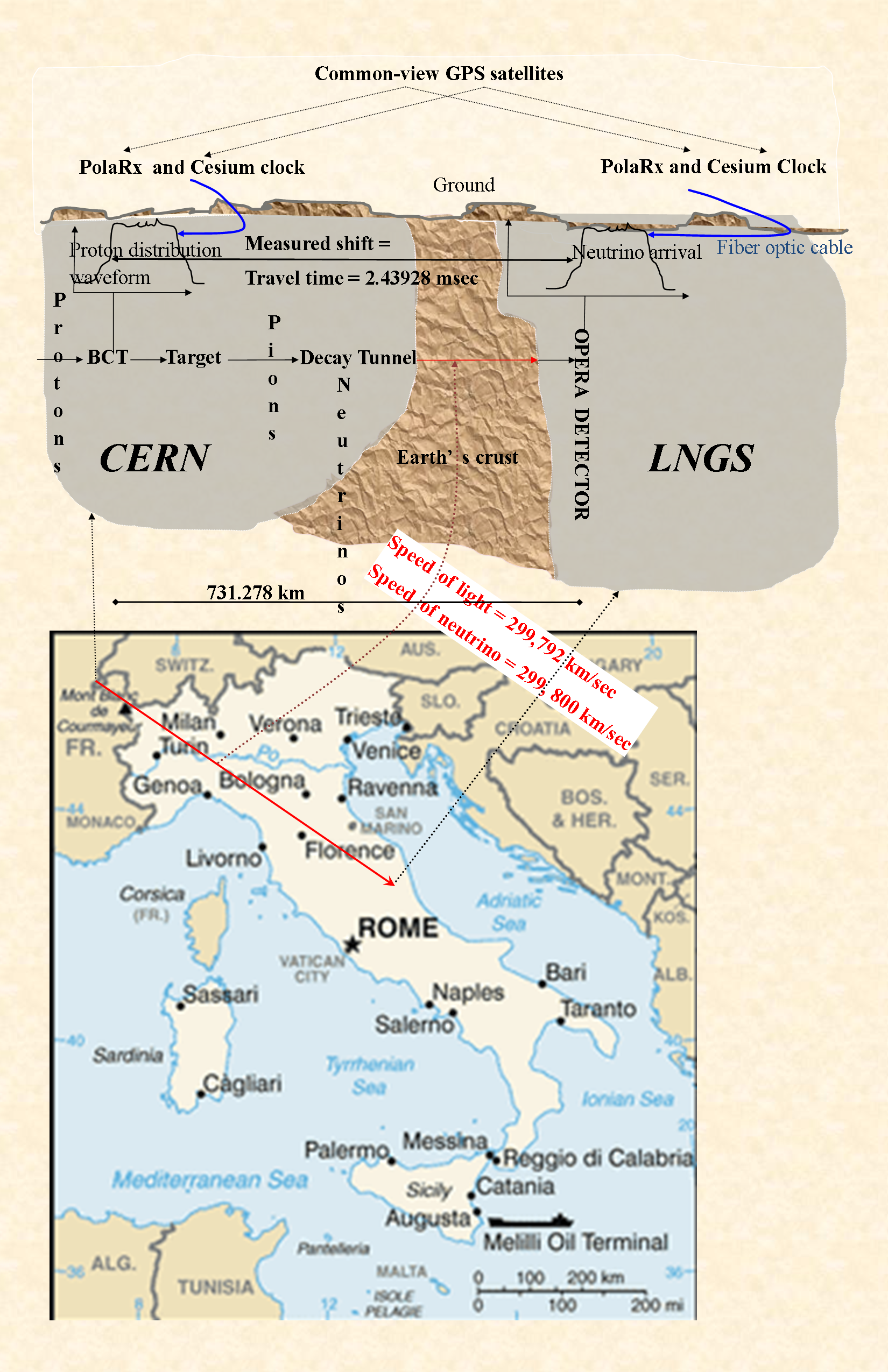
English: The bottom part is a CIA worldbook map. |
||
| Date | |||
| Source | The top part is basically my upload File:TotalTimingSystem.JPG. The bottom part is a CIA worldbook map. | ||
| Author | https://www.cia.gov/library/publications/the-world-factbook/geos/it.html | ||
| Permission (Reusing this file) |
|
Licensing
| Public domainPublic domainfalsefalse |
This image is in the public domain because it contains materials that originally came from the United States Central Intelligence Agency's World Factbook.
Bahasa Indonesia ∙ čeština ∙ Deutsch ∙ eesti ∙ English ∙ español ∙ Esperanto ∙ français ∙ galego ∙ hrvatski ∙ italiano ∙ Nederlands ∙ norsk nynorsk ∙ polski ∙ português ∙ sicilianu ∙ slovenščina ∙ suomi ∙ Türkçe ∙ Zazaki ∙ беларуская (тарашкевіца) ∙ македонски ∙ русский ∙ српски / srpski ∙ українська ∙ ქართული ∙ বাংলা ∙ தமிழ் ∙ മലയാളം ∙ 한국어 ∙ 日本語 ∙ 中文 ∙ 中文(简体) ∙ 中文(繁體) ∙ العربية ∙ +/− |
 |
At https://www.cia.gov/about-cia/site-policies/index.html#copy archive copy at the Wayback Machine, the CIA explicitly marks all files-without-a-copyright-tag on its website as being in the public domain. This map has no tag. The top part is a description of the overall system used by the OPERA experiment. See arXiv eprint 1109.4897, Figure 5. (https://arxiv.org/abs/1109.4897). While this figure is based on that one, nothing has been copied from there - this was drawn from scratch on Microsoft Publisher. Source file is also public domain, and will be provided on request.
Captions
Items portrayed in this file
depicts
26 December 2011
image/png
File history
Click on a date/time to view the file as it appeared at that time.
| Date/Time | Thumbnail | Dimensions | User | Comment | |
|---|---|---|---|---|---|
| current | 19:35, 31 December 2011 | | 1,650 × 2,550 (2.29 MB) | Ajoykt~commonswiki | Parchment background. Stamp the whole figure with the final result, not just the map. |
| 23:41, 28 December 2011 |  | 1,650 × 2,550 (1.7 MB) | Ajoykt~commonswiki | a more sober version. Also, get location of CERN right. | |
| 21:20, 28 December 2011 |  | 1,650 × 2,550 (1.72 MB) | Ajoykt~commonswiki | Accurate distance and time measurements. | |
| 17:35, 28 December 2011 |  | 1,650 × 2,550 (1.72 MB) | Ajoykt~commonswiki | Touchups (would like to delete older versions - no point keeping them around - how do I do it?) | |
| 17:34, 28 December 2011 |  | 1,650 × 2,550 (982 KB) | Ajoykt~commonswiki | Reverted to version as of 23:44, 26 December 2011 | |
| 17:30, 28 December 2011 |  | 1,650 × 2,550 (1.72 MB) | Ajoykt~commonswiki | Minor touchups. | |
| 17:21, 28 December 2011 |  | 1,650 × 2,550 (1.72 MB) | Ajoykt~commonswiki | Make the map, and the earth's crust, a bit bigger. Highlight result more clearly. | |
| 00:24, 28 December 2011 |  | 1,650 × 2,550 (1.19 MB) | Ajoykt~commonswiki | Minor edit to make "art text" clearer to see. Some font-size changes. | |
| 18:15, 27 December 2011 |  | 1,650 × 2,550 (1.16 MB) | Ajoykt~commonswiki | Minor edits to connector overlap and direction of arrows. | |
| 17:45, 27 December 2011 |  | 1,650 × 2,550 (1.16 MB) | Ajoykt~commonswiki | Increase text-font size; take out boxes around text. In general,see if image can be made readable at smaller size. |
File usage
Global file usage
The following other wikis use this file:
- Usage on es.wikipedia.org
- Usage on ru.wikipedia.org
Metadata
This file contains additional information, probably added from the digital camera or scanner used to create or digitize it.
If the file has been modified from its original state, some details may not fully reflect the modified file.
| Horizontal resolution | 59.06 dpc |
|---|---|
| Vertical resolution | 59.06 dpc |
| Software used |