File:Trans-Saharan_roman_expeditions-explorations.png
From Wikipedia, the free encyclopedia
Size of this preview: 719 × 599 pixels. Other resolutions: 288 × 240 pixels | 576 × 480 pixels.
Original file (800 × 667 pixels, file size: 60 KB, MIME type: image/png)
| This is a file from the Wikimedia Commons. Information from its description page there is shown below. Commons is a freely licensed media file repository. You can help. |
Summary
| DescriptionTrans-Saharan roman expeditions-explorations.png |
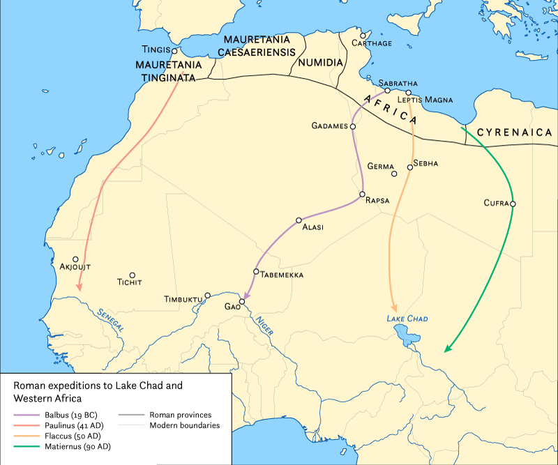
English: Map showing the Roman expeditions south of the Sahara desert in western Africa |
| Date | |
| Source | Own work |
| Author | Cresthaven |
Licensing
I, the copyright holder of this work, hereby publish it under the following license:
This file is licensed under the Creative Commons Attribution-Share Alike 4.0 International license.
- You are free:
- to share – to copy, distribute and transmit the work
- to remix – to adapt the work
- Under the following conditions:
- attribution – You must give appropriate credit, provide a link to the license, and indicate if changes were made. You may do so in any reasonable manner, but not in any way that suggests the licensor endorses you or your use.
- share alike – If you remix, transform, or build upon the material, you must distribute your contributions under the same or compatible license as the original.
Captions
Add a one-line explanation of what this file represents
Items portrayed in this file
depicts
17 February 2015
File history
Click on a date/time to view the file as it appeared at that time.
| Date/Time | Thumbnail | Dimensions | User | Comment | |
|---|---|---|---|---|---|
| current | 18:56, 12 June 2015 | | 800 × 667 (60 KB) | Fixwikimaps | Reverted to version as of 19:20, 3 June 2015 |
| 19:21, 3 June 2015 |  | 500 × 583 (95 KB) | Fixwikimaps | Reverted to version as of 23:19, 17 February 2015 | |
| 19:20, 3 June 2015 |  | 800 × 667 (60 KB) | Fixwikimaps | Updated the map to better reflect the areas in Africa that were explored in Africa. The extent was widened, colors were adjusted, and legend was cleaned up. Map was completed by Hans van der Maarel of Red Geographics | |
| 23:19, 17 February 2015 |  | 500 × 583 (95 KB) | Cresthaven | User created page with UploadWizard |
File usage
The following pages on the English Wikipedia use this file (pages on other projects are not listed):
Global file usage
The following other wikis use this file:
- Usage on ar.wikipedia.org
- Usage on ca.wikipedia.org
- Usage on es.wikipedia.org
- Usage on fr.wikipedia.org
- Usage on pt.wikipedia.org
- Usage on ru.wikipedia.org
- Usage on uk.wikipedia.org
Metadata
This file contains additional information, probably added from the digital camera or scanner used to create or digitize it.
If the file has been modified from its original state, some details may not fully reflect the modified file.
| Software used |
|---|