File:USDA_Hardiness_zone_map.jpg
From Wikipedia, the free encyclopedia
Size of this preview: 601 × 599 pixels. Other resolutions: 241 × 240 pixels | 481 × 480 pixels | 770 × 768 pixels | 1,027 × 1,024 pixels | 2,054 × 2,048 pixels | 4,014 × 4,002 pixels.
Original file (4,014 × 4,002 pixels, file size: 5.92 MB, MIME type: image/jpeg)
| This is a file from the Wikimedia Commons. Information from its description page there is shown below. Commons is a freely licensed media file repository. You can help. |
Summary
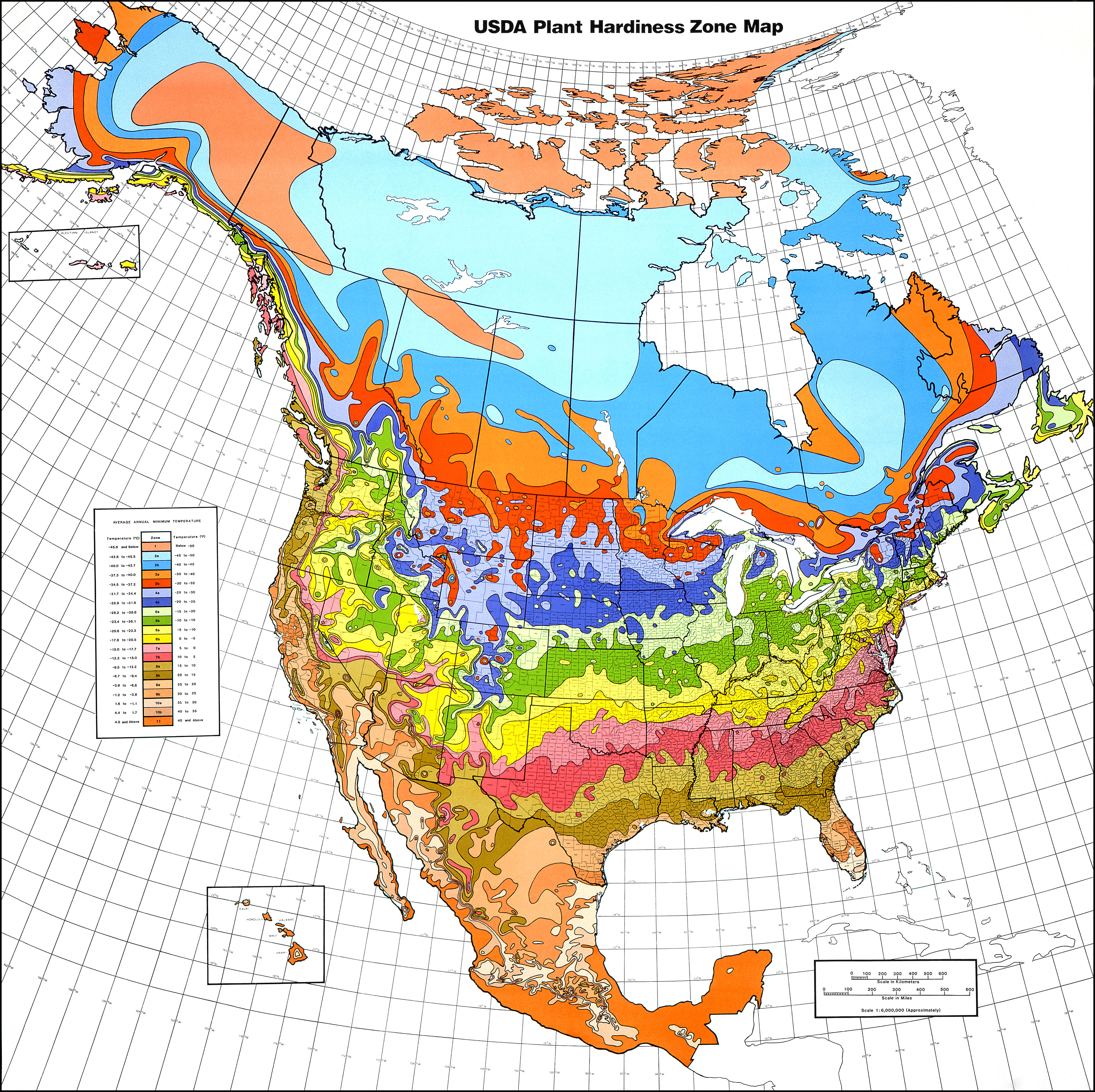
| DescriptionUSDA Hardiness zone map.jpg |
English: USDA Hardiness Zones in North America.
Albers equal area projection, standard parallels of 29.5°N and 45.5°N, scale 1 : 6,000,000 (approx.)
118 × 116 cm (46.4 × 45.6 in) (folded: 30 × 21 cm (11.8 × 8.2 in)) |
| Date | 1990, copied 2006-12-31 |
| Source | USDA plant hardiness zone map 1990 (USDA Miscellaneous Publication No. 1475) ISBN: 0160187478, USDA website |
| Author |
Henry M. Cathey while Director, U.S. National Arboretum, Agricultural Research Service, U.S. Department of Agriculture, Washington, DC 20002
|
| Permission (Reusing this file) |
Public Domain |
| Other versions | File:USDAplanthardiness.jpg (with a bit of frame) |
Licensing
| Public domainPublic domainfalsefalse |
This image or file is a work of a United States Department of Agriculture employee, taken or made as part of that person's official duties. As a work of the U.S. federal government, the image is in the public domain.
English ∙ español ∙ Nederlands ∙ slovenščina ∙ Tiếng Việt ∙ македонски ∙ русский ∙ українська ∙ 日本語 ∙ +/− |
 |
File history
Click on a date/time to view the file as it appeared at that time.
| Date/Time | Thumbnail | Dimensions | User | Comment | |
|---|---|---|---|---|---|
| current | 00:21, 22 January 2013 | | 4,014 × 4,002 (5.92 MB) | Mapmarks | printable size, ca 4000 × 4000 px download from http://planthardiness.ars.usda.gov/PHZMWeb/Images/northamerica.jpg |
| 00:49, 15 October 2008 |  | 588 × 587 (238 KB) | Omegatron | perspective skew and crop - way too low resolution, though [using an external editor] | |
| 15:14, 31 December 2006 |  | 620 × 603 (165 KB) | SB Johnny | {{Information |Description=USDA Hardiness Zones in the US |Source=USDA website: http://www.usna.usda.gov/Hardzone/ushzmap.html |Date=copied 2006-12-31 |Author= |Permission=Public Domain |other_versions= }} {{PD-USGov}} |
File usage
The following pages on the English Wikipedia use this file (pages on other projects are not listed):
Global file usage
The following other wikis use this file:
- Usage on ca.wikipedia.org
- Usage on en.wikibooks.org
- Usage on et.wikipedia.org
- Usage on fa.wikipedia.org
- Usage on fi.wikipedia.org
- Usage on fr.wikipedia.org
- Usage on he.wikipedia.org
- Usage on hu.wikipedia.org
- Usage on pl.wikipedia.org
- Usage on zh.wikipedia.org
Metadata
This file contains additional information, probably added from the digital camera or scanner used to create or digitize it.
If the file has been modified from its original state, some details may not fully reflect the modified file.
| Width | 4,014 px |
|---|---|
| Height | 4,002 px |
| Bits per component |
|
| Compression scheme | Uncompressed |
| Pixel composition | RGB |
| Orientation | Normal |
| Number of components | 3 |
| Horizontal resolution | 300 dpi |
| Vertical resolution | 300 dpi |
| Data arrangement | chunky format |
| Software used | Adobe Photoshop 7.0 |
| File change date and time | 10:59, 15 April 2010 |
| Color space | Uncalibrated |
| Image width | 4,014 px |
| Image height | 4,002 px |
| Date and time of digitizing | 07:01, 29 July 2008 |
| Date metadata was last modified | 07:01, 29 July 2008 |
| IIM version | 2 |
Retrieved from "https://en.wikipedia.org/wiki/File:USDA_Hardiness_zone_map.jpg"