File:US_Geological_Provinces.png
From Wikipedia, the free encyclopedia
US_Geological_Provinces.png (628 × 372 pixels, file size: 289 KB, MIME type: image/png)
| This is a file from the Wikimedia Commons. Information from its description page there is shown below. Commons is a freely licensed media file repository. You can help. |
Summary
| DescriptionUS Geological Provinces.png |
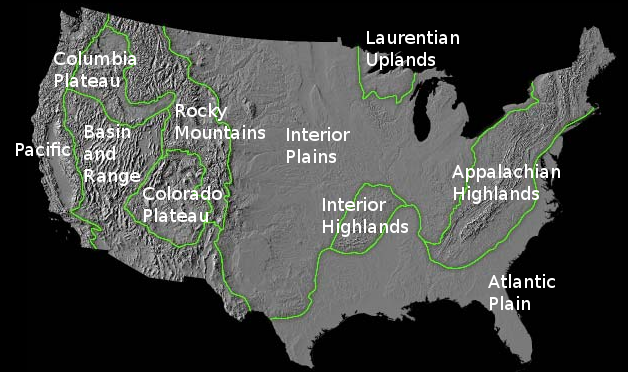
English: Map of U.S. Geological Provinces. Relief map and outline from USGS, labels added by Hike395 at English Wikipedia |
| Date | |
| Source | Archived source link |
| Author | USGS, labels by Hike395 (talk · contribs) |
| Permission (Reusing this file) |
PD-USGov-USGS, CC0 |
| Other versions |
Licensing
| Public domainPublic domainfalsefalse |
This image is in the public domain in the United States because it only contains materials that originally came from the United States Geological Survey, an agency of the United States Department of the Interior. For more information, see the official USGS copyright policy.
Bahasa Indonesia ∙ català ∙ čeština ∙ Deutsch ∙ eesti ∙ English ∙ español ∙ français ∙ galego ∙ italiano ∙ Nederlands ∙ português ∙ polski ∙ sicilianu ∙ suomi ∙ Tiếng Việt ∙ Türkçe ∙ български ∙ македонски ∙ русский ∙ മലയാളം ∙ 한국어 ∙ 日本語 ∙ 中文 ∙ 中文(简体) ∙ 中文(繁體) ∙ العربية ∙ فارسی ∙ +/− |
Labels released in the public domain:
| This file is made available under the Creative Commons CC0 1.0 Universal Public Domain Dedication. | |
| The person who associated a work with this deed has dedicated the work to the public domain by waiving all of their rights to the work worldwide under copyright law, including all related and neighboring rights, to the extent allowed by law. You can copy, modify, distribute and perform the work, even for commercial purposes, all without asking permission.
http://creativecommons.org/publicdomain/zero/1.0/deed.enCC0Creative Commons Zero, Public Domain Dedicationfalsefalse |
Captions
Items portrayed in this file
depicts
12 May 2013
File history
Click on a date/time to view the file as it appeared at that time.
| Date/Time | Thumbnail | Dimensions | User | Comment | |
|---|---|---|---|---|---|
| current | 05:56, 13 May 2013 | | 628 × 372 (289 KB) | Hike395 | {{Information |Description ={{en|1=Map of U.S. Geological Provinces. Relief map and outline from USGS, labels added by {{User at project|Hike395|wikipedia|en}}}} |Source =http://geomaps.wr.usgs.gov/parks/province/list.html |Author =U... |
File usage
Metadata
This file contains additional information, probably added from the digital camera or scanner used to create or digitize it.
If the file has been modified from its original state, some details may not fully reflect the modified file.
| Horizontal resolution | 28.35 dpc |
|---|---|
| Vertical resolution | 28.35 dpc |
| File change date and time | 05:19, 13 May 2013 |