File:Vietnam_(1009-1225).png
From Wikipedia, the free encyclopedia
No higher resolution available.
Vietnam_(1009-1225).png (431 × 465 pixels, file size: 20 KB, MIME type: image/png)
| This is a file from the Wikimedia Commons. Information from its description page there is shown below. Commons is a freely licensed media file repository. You can help. |
Summary
| DescriptionVietnam (1009-1225).png |
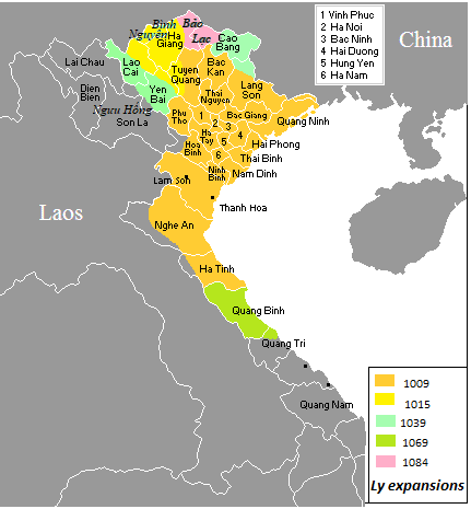
English: Annam in 1009–1225. |
| Date | |
| Source | Own work |
| Author | Night Lantern |
| Permission (Reusing this file) |
This file is licensed under the Creative Commons Attribution-Share Alike 3.0 Unported license.
|
Captions
Add a one-line explanation of what this file represents
Quá trình mở rộng lãnh thổ Việt Nam (Đại Cồ Việt, Đại Việt) dưới triều nhà Lý (1009-1225)
Items portrayed in this file
depicts
some value
7 December 2006
image/png
File history
Click on a date/time to view the file as it appeared at that time.
| Date/Time | Thumbnail | Dimensions | User | Comment | |
|---|---|---|---|---|---|
| current | 16:38, 8 May 2022 | | 431 × 465 (20 KB) | Sgnpkd | Remove redundant maps, clearer legends |
| 03:47, 17 February 2020 | 860 × 3,575 (523 KB) | Doãn Hiệu | Điều chỉnh lại chính xác quá trình mở rộng lãnh thổ của Đại Cồ Việt-Đại Việt thời nhà Lý. | ||
| 06:46, 25 February 2019 |  | 860 × 715 (53 KB) | Doãn Hiệu | thêm địa danh | |
| 01:52, 10 February 2019 |  | 860 × 715 (47 KB) | Doãn Hiệu | sửa biên giới tây Nghệ An. | |
| 02:31, 7 February 2019 |  | 860 × 715 (47 KB) | Doãn Hiệu | Điều chỉnh biên giới miền tây xứ Nghệ: thời nhà Lý chưa có phủ Trà Lân, Ngọc Ma (Tương Dương, Con Quông, Hương Sơn). | |
| 06:25, 6 February 2019 |  | 860 × 715 (47 KB) | Doãn Hiệu | Điều chỉnh biên giới phía tây bắc thời nhà Lý: Vùng Bát Xát, Lào Cai là châu Thủy Vĩ theo Đào Duy Anh châu Thủy Vĩ thời Lý là đất Băng Châu của Đại Việt, huyện Văn Bàn và Văn Chấn là đất Đặng Châu Đại Việt. Nghĩa Lộ (Mường Lò), Than Uyên (Mường Than) là đất của các bộ tộc người Thái Đen và Thái Trắng, trong đó Mường Lò theo Quam-to-muong là đất bàn ban đầu người Thái Đen chinh phục tây bắc lập nên tiểu quốc Ngưu Hống vào thế kỷ 10 ở Tây bắc. | |
| 13:32, 3 January 2019 |  | 428 × 713 (28 KB) | Doãn Hiệu | Điều chỉnh niên đại tiến trình. | |
| 03:10, 1 January 2019 |  | 428 × 713 (27 KB) | Doãn Hiệu | thêm Hoàng Sa và Côn Đảo. | |
| 01:38, 1 January 2019 |  | 428 × 713 (27 KB) | Doãn Hiệu | Điều chỉnh vùng lãnh thổ nay là tỉnh Quảng Bình. | |
| 01:19, 1 January 2019 |  | 428 × 713 (27 KB) | Doãn Hiệu | Điều chỉnh vùng lãnh thổ nay là tỉnh Hà Giang và vùng lãnh thổ tây bắc Việt Nam. |
File usage
The following pages on the English Wikipedia use this file (pages on other projects are not listed):
Global file usage
The following other wikis use this file:
- Usage on ko.wikipedia.org
- Usage on vi.wikipedia.org
Metadata
This file contains additional information, probably added from the digital camera or scanner used to create or digitize it.
If the file has been modified from its original state, some details may not fully reflect the modified file.
| Horizontal resolution | 37.79 dpc |
|---|---|
| Vertical resolution | 37.79 dpc |
Retrieved from "https://en.wikipedia.org/wiki/File:Vietnam_(1009-1225).png"
.png)