File:Vijayalaya_territories.png
From Wikipedia, the free encyclopedia
Original file (2,372 × 1,485 pixels, file size: 1.17 MB, MIME type: image/png)
Summary[edit]
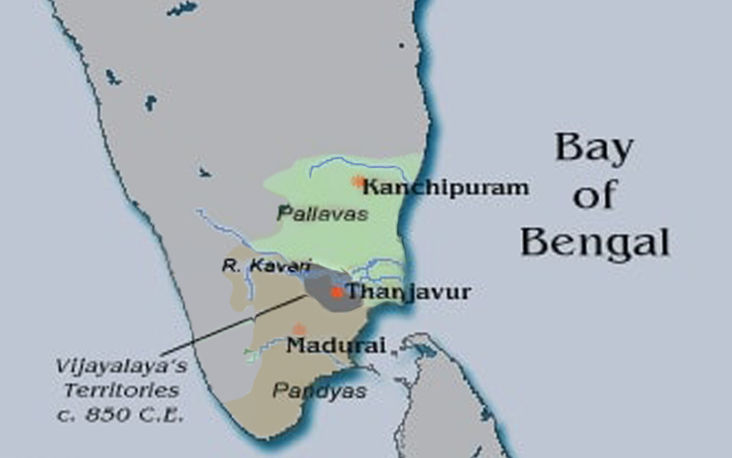
Approximate extent of the Chola territories during the reign of Vijayalaya. This map was created from the Online Map Creation tool found at http://www.aquarius.geomar.de/. Further modifications were made using Adobe Photoshop.
Licensing[edit]
 | I, the creator of this work, hereby grant the permission to copy, distribute and/or modify this document under the terms of the GNU Free Documentation License, Version 1.2 or any later version published by the Free Software Foundation; with no Invariant Sections, no Front-Cover Texts, and no Back-Cover Texts. Subject to disclaimers.
GFDL with disclaimers GNU Free Documentation License with disclaimers //en.wikipedia.org/wiki/Wikipedia:Text_of_the_GNU_Free_Documentation_License |
| This work is licensed under the Creative Commons Attribution-ShareAlike 3.0 License. This licensing tag was added to this file as part of the GFDL licensing update. Cc-by-sa-3.0Attribution-ShareAlike 3.0https://creativecommons.org/licenses/by-sa/3.0/ |
 | This file is a candidate to be copied to Wikimedia Commons.
Any user may perform this transfer; refer to Wikipedia:Moving files to Commons for details. If this file has problems with attribution, copyright, or is otherwise ineligible for Commons, then remove this tag and DO NOT transfer it; repeat violators may be blocked from editing. Other Instructions
| ||
| |||
File history
Click on a date/time to view the file as it appeared at that time.
| Date/Time | Thumbnail | Dimensions | User | Comment | |
|---|---|---|---|---|---|
| current | 10:34, 14 March 2020 | | 2,372 × 1,485 (1.17 MB) | StephenPaa (talk | contribs) | Corrected borders |
| 02:43, 13 February 2006 |  | 344 × 208 (13 KB) | Venu62 (talk | contribs) | Map created using the Online Map Creation tool available at http://www.aquarius.geomar.de/ and modified by me using Adobe Photoshop. The Map indicates the approximate extent of the Chola territories during Vijayalaya (c. 850 C.E.). | |
| 23:48, 12 February 2006 |  | 313 × 173 (9 KB) | Venu62 (talk | contribs) | Approximate extent of the Chola territories during the reign of Vijayalaya. This map was created from the Online Map Creation tool found at http://www.aquarius.geomar.de/. Further modifications were made using Adobe Photoshop. |
You cannot overwrite this file.
File usage
Metadata
This file contains additional information, probably added from the digital camera or scanner used to create or digitize it.
If the file has been modified from its original state, some details may not fully reflect the modified file.
| Horizontal resolution | 28.35 dpc |
|---|---|
| Vertical resolution | 28.35 dpc |