File:Woofferton_station_(disused)_-_geograph.org.uk_-_316919.jpg
From Wikipedia, the free encyclopedia
No higher resolution available.
Woofferton_station_(disused)_-_geograph.org.uk_-_316919.jpg (640 × 480 pixels, file size: 102 KB, MIME type: image/jpeg)
| This is a file from the Wikimedia Commons. Information from its description page there is shown below. Commons is a freely licensed media file repository. You can help. |
Summary
| DescriptionWoofferton station (disused) - geograph.org.uk - 316919.jpg |
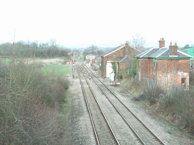
English: Woofferton station (disused) The site of the former station at Woofferton. The posts that once held the station nameboard still stand, just to the right. The next building after the station buildings was formerly the goods shed.
Woofferton was a junction station, with a branch line running to Bewdley, via Tenbury Wells. This line diverged to the right from the current, main line just after the station. |
| Date | |
| Source | From geograph.org.uk |
| Author | David Luther Thomas |
| Attribution (required by the license) InfoField | David Luther Thomas / Woofferton station (disused) / |
InfoField | David Luther Thomas / Woofferton station (disused) |
| Camera location | 52° 18′ 36″ N, 2° 42′ 54″ W | View this and other nearby images on: OpenStreetMap |
|---|
| Object location | 52° 18′ 39″ N, 2° 42′ 51″ W | View this and other nearby images on: OpenStreetMap |
|---|
Licensing

|
This image was taken from the Geograph project collection. See this photograph's page on the Geograph website for the photographer's contact details. The copyright on this image is owned by David Luther Thomas and is licensed for reuse under the Creative Commons Attribution-ShareAlike 2.0 license.
|
This file is licensed under the Creative Commons Attribution-Share Alike 2.0 Generic license.
Attribution: David Luther Thomas
- You are free:
- to share – to copy, distribute and transmit the work
- to remix – to adapt the work
- Under the following conditions:
- attribution – You must give appropriate credit, provide a link to the license, and indicate if changes were made. You may do so in any reasonable manner, but not in any way that suggests the licensor endorses you or your use.
- share alike – If you remix, transform, or build upon the material, you must distribute your contributions under the same or compatible license as the original.
Captions
Add a one-line explanation of what this file represents
Items portrayed in this file
depicts
some value
20 January 2007
52°18'36.22"N, 2°42'54.36"W
52°18'38.81"N, 2°42'51.12"W
File history
Click on a date/time to view the file as it appeared at that time.
| Date/Time | Thumbnail | Dimensions | User | Comment | |
|---|---|---|---|---|---|
| current | 16:16, 30 December 2010 | | 640 × 480 (102 KB) | GeographBot | == {{int:filedesc}} == {{Information |description={{en|1=Woofferton station (disused) The site of the former station at Woofferton. The posts that once held the station nameboard still stand, just to the right. The next building after the station building |
File usage
The following pages on the English Wikipedia use this file (pages on other projects are not listed):
Global file usage
The following other wikis use this file:
- Usage on www.wikidata.org
Metadata
This file contains additional information, probably added from the digital camera or scanner used to create or digitize it.
If the file has been modified from its original state, some details may not fully reflect the modified file.
| Image title | Exif_JPEG_PICTURE |
|---|---|
| Camera manufacturer | RICOH |
| Camera model | Caplio R5 |
| Copyright holder | (C) by Caplio R5 User |
| Exposure time | 11,184,811/33,554,432 sec (0.33333334326744) |
| F-number | f/4.6999998092651 |
| ISO speed rating | 200 |
| Date and time of data generation | 16:51, 20 January 2007 |
| Lens focal length | 12.300000190735 mm |
| Orientation | Normal |
| Horizontal resolution | 486 dpi |
| Vertical resolution | 486 dpi |
| File change date and time | 01:07, 21 January 2007 |
| Y and C positioning | Centered |
| Exposure Program | Normal program |
| Exif version | 2.2 |
| Date and time of digitizing | 16:51, 20 January 2007 |
| Image compression mode | 1.6000000238419 |
| APEX aperture | 4.5 |
| APEX brightness | 1.3999999761581 |
| Exposure bias | 1 |
| Maximum land aperture | 3.2999999523163 APEX (f/3.14) |
| Metering mode | Pattern |
| Light source | Unknown |
| Flash | Flash did not fire, compulsory flash suppression |
| Color space | sRGB |
| Exposure mode | Auto exposure |
| White balance | Auto white balance |
| Scene capture type | Standard |
| Sharpness | Hard |
_-_geograph.org.uk_-_316919.jpg)