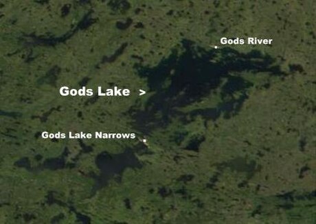
Gods River is a remote, isolated settlement in Northern Manitoba, Canada, and the primary settlement of the Manto Sipi Cree Nation (Cree: ᒪᓂᑐ ᓰᐱᐩ, manito sîpiy) (54°50′15″N 94°03′17″W) First Nations community. The settlement is on Gods Lake at the point of outflow of the Gods River.
Manto Sipi Cree Nation
God's River ᒪᓂᑐ ᓰᐱᐩ manito sîpiy | |
|---|---|
| God's River 86A | |
Location of God's Lake in Manitoba | |
| Coordinates: 54°50′11″N 94°03′23″W | |
| Country | Canada |
| Province | Manitoba |
| Region | Northern |
| Government | |
| • MP (Churchill—Keewatinook Aski) | Niki Ashton (NDP) |
| • MLA (Keewatinook) | Ian Bushie (NDP) |
| Area | |
| • Total | 4.01 km2 (1.55 sq mi) |
| Elevation | 170 m (560 ft) |
| Population (2016[1]) | |
| • Total | 643 |
| • Density | 160.2/km2 (415/sq mi) |
| Time zone | UTC-6 (CST) |
| • Summer (DST) | UTC-5 (CDT) |
| Website | https://mantosipicree.ca |
The community can only be reached by winter road or by air via Gods Lake Airport.
The official languages of the community are English and Cree. There is a lodge for tourists to stay for visits to the community. Population is approximately 400-700 community members as of 2021.
 |
References
External links
Wikiwand in your browser!
Seamless Wikipedia browsing. On steroids.
Every time you click a link to Wikipedia, Wiktionary or Wikiquote in your browser's search results, it will show the modern Wikiwand interface.
Wikiwand extension is a five stars, simple, with minimum permission required to keep your browsing private, safe and transparent.

