Loading AI tools
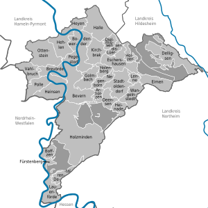
Holzminden (German pronunciation: [hɔltsˈmɪndn̩]) is a district in Lower Saxony, Germany, with the town of Holzminden as its administrative capital. It is bounded by (from the north and clockwise) the districts of Hamelin-Pyrmont, Hildesheim and Northeim, and by the state of North Rhine-Westphalia (districts of Höxter and Lippe).
Holzminden | |
|---|---|
 Flag  Coat of arms | |
 | |
| Country | Germany |
| State | Lower Saxony |
| Capital | Holzminden |
| Government | |
| • District admin. | Michael Schünemann |
| Area | |
| • Total | 692 km2 (267 sq mi) |
| Population (31 December 2022)[1] | |
| • Total | 70,911 |
| • Density | 100/km2 (270/sq mi) |
| Time zone | UTC+01:00 (CET) |
| • Summer (DST) | UTC+02:00 (CEST) |
| Vehicle registration | HOL |
| Website | landkreis-holzminden.de |
The district was established in 1833 within the Duchy of Brunswick-Lüneburg. It was moved to the Prussian Province of Hanover as part of a territorial exchange in 1942. The last territorial modification was in 1974.
The district is located in the Weserbergland mountains, roughly between Hamelin and Göttingen. The Weser River forms the southwestern border of the district and runs through its northern parts.
The lion is taken from the arms of the County of Everstein; the counts ruled over the region in the 14th century and were the founders of the City of Holzminden. The bar in the bottom is symbolising the Weser River.
| Towns | Samtgemeinden | |
|---|---|---|
|
|
|
|
| 1seat of the Samtgemeinde; 2town | ||
 Głubczyce County, Poland
Wikiwand in your browser!
Seamless Wikipedia browsing. On steroids.
Every time you click a link to Wikipedia, Wiktionary or Wikiquote in your browser's search results, it will show the modern Wikiwand interface.
Wikiwand extension is a five stars, simple, with minimum permission required to keep your browsing private, safe and transparent.